Good afternoon, gang. After another below 0 morning for much of the region, it’s time to focus on a busy pattern ahead of us. This is a pattern that is likely to lead to a couple of smack down winter storms in our part of the world in February.
Some random thoughts on the next week…
– The system rolling in for the end of the week and weekend isn’t a pretty one. Starts as a bit of a mix… goes to rain for Saturday… then some mix and snow a good bet Sunday into early Monday. That could lay down some light accumulations.
– I was going through my twitter timeline just a bit ago and noticed many, many people talking about a snowstorm coming next week. Many of them were citing other weather sources. My advice is to be careful where you get your weather information with the kind of system coming our way next week.
– That’s a storm system that will have a ton of moisture with it and it could take on many different forms across Kentucky. Snow, ice, rain or any combo of the three will be possible next week. Here’s how broad of a reach the winter side of this system may have…
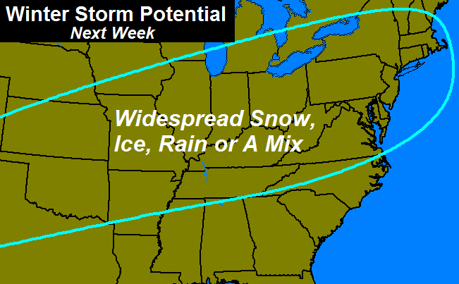
– This is likely to become a big ticket weather maker for our region and for much of the country. The look of this certainly suggests some nasty winter weather around here, it’s still a week away.
– Use caution with where you get your weather information from.
Take care.

You mean there are other places that you can get weather info? I don’t believe it!!!!!!!!!!!!!!!!!!!!!!!!!!!!!!!!!!!!
Hahaha
I always go to the best source available: Chris Bailley!
Frankly i would be surprised if folks that read this blog would expect a snow event. You have clearly stated the likeliness of a mix including ice as potential. Most of us know the drill from there, since have a lot of history to support it. Let us hope warm air wins and the ice chances are minimal. Then again, warm air is a key reason for ice in the first place, so let us just hope for mainly rain.
If CB starts word clouding “ice” a lot, we might be in trouble.
Only place I get my info is here (Thanks Mr. Bailey)!!!!! And Marc Weinberg over on the wdrb blog. Those guys are really good and accurate like CB too.
Agreed. WDRB does the best job overall.
Except, without question, Mr. Bailey
Burn the heretic! 😉
Way too early to tell what is coming yet. Hope it’s snow but time will tell. Thanks Chris.
Too true. This time of year, anything past 36 hours is an educated guess, particularly in southern Kentucky.
Thankful we have you!
The Bering Sea and East Asia correlation say it’ll be a west to east storm. But with ridiging in the Pacific and high pressure building in the eastern U.S. that the models aren’t picking up on yet, makes me believe this will be a Great Lakes Cutter when it gets to the Ohio Valley. If it takes the West to east track, we could see some nasty winter weather. Since February is historically speaking our best month for snowfall amounts, I’m very interested in how this unfolds.
Had to copy this comment from the last post so I could address the comment, read on:
How can two models be so different. They aren’t even close!!! I love Bailey, but why put this crap on here. 12 inches in KY will NOT happen. I don’t even understand the models, but trust me…NADA. For one, it is too far out…that can’t be predicted. Why do this to us. On WHAS11, WAVE3, WDRB12….none have this happening or even a possibility. Tired of getting my hopes up. Prove me wrong.
Bailey doesn’t predict anything a week out. He says what could happen based on the model, then provides a visual to those that want to see. The television channels listed generally are horrible aside from WAVE. However, NO one will claim a snow storm a week out. And neither is Chris. It is to far out, but there’s nothing to “prove” here.
I think anything is possible with the way the freaky weather patterns have been ,GA has snow and 1,000’s of cars piled up from ice ,anything is possible.It may have been @20 yrs since KY has seen these type of temps,but the fact is it has happened! To the person that you quoted as saying “12 inches isnt possible in KY” well in two storms a few days apart I measured 8 inches in my yard,not counting what melted,with drifts well over 12 inches so the said sceptic is wrong! stay warm all !
I can’t believe people in KY think we are actually going to get a winter storm. Where have they been the last 16yrs or so?
Saying we are over due is understated in these parts. I hope you can get in on some of the snow love too Andy. Just crazy how all of this snow could keep missing the same parts over and over. Bubba,we need a Bubba buster. Can you make it happen? I for one am going to be ready for spring when it gets here. Hopefully not cold this the middle of May again. Thanks CB
Hopefully not cold “til” the middle of May.
Chris thanks for the Update…CB is the best Met in Ky with John Belski a very close 2nd in my book.
Seven days out and we get a map that shows a potential for winter weather from Michigan thru Tenn. Only means one thing for Kentucky (who sits in the upper lower half of the map) ICE ICE Baby. These next five days of model watching should get real interesting with the amout of moisture involved and large amout of cold that is already over much of the Eastern half of the US. This could turn out to be a Historic storm for some.
I find it interesting that you say, “Use caution with where you get your weather information from.” This hopefully includes WKYT because it is often amazing how your own team members have varying forecast from broadcast to broadcast and how frequently those differ from what I see here. Whatever the case, you are still my primary go to weather source!
I’m no weatherperson, by any means, but it seems to me that NOBODY KNOWS, at this point, where this thing is going to go, esp. not the models. (They’re all @ “Waffle House”..lol!) If I had to make a long-range guess, I would say the chances look good for it to go just to the North of KY, for the snow part, and then the middle/central parts of the state get the Ice Storm…southern areas, all heavy rain. But that’s just speculative, based on how these things have trended in the past for us. Just sayin’….but we won’t know anything at all until about 12-24 hrs. out, because this will be another “nowcasting” event, for sure! (Aren’t they ALL, lately???! 🙁 )
Sounds spot on based on past trends, but maybe this winter still has something to prove for us big snow lovers in ky, we shall see how this plays out!
Hey Bubba, here’s a prediction for you. If the storm happens in a week anywhere near the scope its being discussed now, it the narrative will be “the storm we’ve been talking about happening for a week now”. If it fizzles out and becomes a non-issue, it will be “the models just couldn’t get a handle on factor X and this accounts for the miss”. You’re intelligent enough to know exactly what I’m talking about.
As to the not even thinly veiled slams on “other weather sources”, anyone have a clue as to who this pertains? I’m not around enough to keep current on the lunchroom drama. If it’s who I hope it is, I’m totally fine with it. 🙂
Simple standard for me is that CB is not seeing this as an all snow event. Factor in the models always trend worse than better (EVERY time), that would suggest an all snow at this point or mainly snow has a slim to none chance.
Even these last last two events were under performers for a lot of people and hand fairly tight bands of coverage and very light for others. The only given so far this winter is the models on average have nailed the amount of moisture, but not in any stretch the type that actually falls over most of Kentucky.
12z EURO just buries most of KY in snow next Tue-Wed. 1-2 feet in some cases
Have a link drew?
More eye candy 😉
You beat me to it. Areas along the Ohio River would be digging out for a week IF something like that Euro model run verified!!
I just wish that was tomorrow and not next week!
The models should have a disclaimer, “for entertainment purposes only” this far out. Would love to see it verify!!
Here are my thoughts on these upcoming storms for Kentucky:
The first system this weekend will mainly be rain, with a light mix to start in areas north of I 64. Minor snow accumulations less than an inch are possible in nky.
The Tuesday and Wednesday system looks to begin with some freezing rain. Freezing rain will change over to plain rain along and south of the I 64 corridor by daybreak while continuing to ice up over southern indiana, ohio, and northern kentucky. Eventually enough warm air will change these areas over to rain but a flash freeze will occur Wednesday night once this system departs causing lots of issues for everyone in Kentucky (pretty confident in that last part).
I believe this forecast is Bubba-approved 😉
At least the good news on the two flash freezes so far this winter has been the wind blows a lot of areas here dry before the freezing started 🙂 So far……
Seems a given at this point that the diagonal-ish pattern of Fencetucky would prevail- of which a key point being I64. Question would be what mainly falls around that fence….
South of the fence might not be too pretty if north of it is mainly snow and south mainly ice. IF.
The official name of the Tues-Wed storm is “Fencetta”!
LOL!! 😛
The post of the year!!!!!
Might as well since the national met hypers are LAMELY calling winter systems names now.
I was looking at the EMCWF model runs, and the 10 day snowfall forecast puts down 12″-15″ in northern and eastern Kentucky. I know that we are several days out from this system, but there’s always a possibility.
The latest Euro run is going to blow up social media! It’s a picture of beauty for snow lovers!
Especially since the Euro is a bit better farther ahead in time than, say, the GFS.
Of course, it’s still very early. Even the Euro is not infallible.
Someone show us the EURO snow map…
Do you know you can get the free Euro snow map on wunderground..
It’s not good to be in the bull’s eye this early..SE ridge will say go to the lake’s little fellow..
Surprised nobody has brought up the date of this upcoming storm.
Feb. 4th is Tuesday. 1998, when 23″ fell in Louisville, it started Feb. 4th (a Wednesday). So, this is right at the 16 yr anniversary of the infamous Tom Wills’ 1″ or less forecast with all rain, ending as wraparound snow and mix.
Could this be the storm that busts the local MET’s forecasts and wallops us?
Even the temp profiles are similar. Should be very interesting.
I just enjoyed my 2″ yesterday in Middlesboro that was just suppose to be flurries. Lol.
I’d love to know where you guys are finding these EURO snowfall maps because I cant find them? The EURO site I found doesn’t even have snowfall maps.
Cherry pickers, they be! They like them as long as they show snow. When they switch to ice or rain they will be forgotten like New Coke.
People are forgetting how many times ky has been in the cross hairs a week away, I’m not drinking the coolaide just yet!
https://kyweathercenter.com/wp-content/uploads/2013/12/Special7.png
that was dec. 15th…three days later we had flooding rains!! Just saying pic looks familiar to the untrainded eye?
Let folks enjoy their cherries. Choice pickins’ 🙂 😉
And i was told it wouldn’t happen i remember that all to clearly.
Last night’s run had all of Tenn with over a foot of snow..Today’s run now has half of Ky with all of Ohio,Part’s of Southern ILL,Southern Ind..Low tracks through East Tenn,Ky looks like to me..All rain before every thing is said and done for us East folks who will be under a South East ridge…Wxbell clown maps at it’s finest..
Models = got those moves like Jagger……Always moving around, little crazy at times,
Looks promising with good agreement this far out
http://fox41blogs.typepad.com/wdrb_weather/2014/01/models-in-better-agreement-concerning-potential-winter-storm-next-week.html
Folks seems to be doing what CB is concerned: People are equating storm to snow. Since winter this is understandable, but flawed given our history and the mix the storm appears to be implying. Watch for “ice” in the word cloud.
Dodger says you must be married to Debbie Downer! Geez, you should have held out for Ms Optimism! Dodger!
Hey Chris. I get all my weather forecast from KYC and all you guys with WKYT AND WYMT. You all are the best. And I hope we get a big snow here in Wallins in Harlan County.
I think a couple of points are worth noting about the storm next week. First, all three have a low pressure in the area that would usually promote snow. With the exception of the Euro though, the GFS and CMC show most of Kentucky missing out on snow. That suggests strong southwest winds at 850 warm us up and produce mostly rain.
Second, the GFS, as was noted by WDRB is weaker, but also farther north. Normally, weaker storms remain to the south while stronger storms, as shown by the Euro and CMC, move or “cut” north. So at least to my very untrained eye, that goes against much of what we’ve seen in the past.
Third, the GFS is almost always crushed by observers, but I suspect it’s going to be more right on the track, at least, than the others. A storm that cuts from Memphis towards Louisville is the usual track. Now to be fair, this hasn’t been a usual winter, but the odds suggest a GFS like track.
Marc Weinberg on the news made a comment that some have been spreading hype about a big storm next week. He’s so dramatic and arrogant LOL. Was he trying to call out Chris or someone else?
He pretty much called his shot on the 4PM news today. He said he favored mostly rain with a few flurries or light snow showers on the back end. I wish he’d have said differently, but the climatology favors a track from Memphis to Louisville.
I hope he’s wrong. I’ve seen him before make a call, be wrong, and then try to act like he was still right?
FOLKS THIS PATTERN SETTING UP IS OLD SCHOOL written all over it. the southern jet involved and that spells trouble for the SE.. this has turn into a longtime WINTER and she ainty done yet!!!!
Rolo,
You need to make sure everybody is safely strapped in before the Rolocoaster ride starts 🙂
Arms up in the air and let it ride.
Rolo welcome back to the party! We have had plenty of old school temperatures, we just need the old school snow to cap off a winter to remember!
Welcome Back Rolo!! Glad your better!
Good to have you back rolo but its not the 1st time we have heard that and to flooding rain so i will chip the ice off my boat and blow up my floatation devices
maybe you should call matt Jones on the radio, he said YOU are saying that we could get up to 18 inches on Tuesday. I believe you over him, but his show has a huge audience and it makes you look bad.
Hmm, its like this: WSAZ is my home page but the first place I click for weather is Chris Bailey’s blog because it’s updated at least twice a day. He has the tracking tools and a brief summary of what might/will happen. There’s always variations in the weather. It’s hard to pinpoint the exact outcome of a storm, but his weather blog is always updated so we will potentially know what kind of weather we will face. It takes dedication to keep blogs updated and I want to give Chris Bailey a big thumbs up for all the hard work he puts into his job!
There is going to be a storm next week. Guaranteed.
I agree.
Three main models have similar but different solutions 5 days out. That’s rare and Dodger thinks that’s meaningful. Big snow and ice! Dodger!
So why is a storm track from Memphis to Louisville typical? I didn’t think storms had a “typical” track………they track all over the place, don’t they? I know they name storm tracks……apps runner, lakes cutter, etc……..
Interesting there’s a distinctive track they always take. No wonder we never get snow from the southern systems. So tell me…..what would the track be named if the low ends up going through southern TN, northern, AL? Does that track have a name?
That’s called the No Way track 😉
Generally speaking, they’re called App runners (after the mountains). It’s not a very common track though.
Whoops. I didn’t read your comment as thoroughly as I should have. My mistake.
My call is the front tracks north against bias of the model. 35+ degree rain I 64 south, north of that line to see ice snow mix. Flooding rain in the south. looks like lots of moisture with this one. I LOVE SNOW and am very thankful for what we have got this year, but don’t get your snow hopes up for this one. Instead hope for everyone to be safe.
This the only source I use for weather information. The best one.
WHAT?!!! They cant predict the weather a week from now? What about Global Warming then? How will we know how hot it will be in ten, twenty or fifty years from now??????