Good evening, gang. The pattern ahead is getting a lot of buzz and for good reason. It’s one that is loaded with storm potential as we head into February. It is important to note the word POTENTIAL. While I do believe February will deliver plenty of snow around here, it doesn’t mean every system will be snow. That simply doesn’t happen.
The first system I’m tracking arrives over the weekend and will bring a rain or snow shower for Friday with rain on Saturday. Your Super Bowl Sunday will find colder temps moving in with the possibility of some light snow or a light mix. That may continue into Monday, but doesn’t look like a huge deal right now.
What’s getting all the attention is the storm for the middle of next week. This has been on my radar for a while and it continues to show up well on the models. Unfortunately, the models will show different solutions from one run to the next and that’s to be expected.
The European Model shows this storm taking a track across the eastern Ohio Valley by Wednesday…
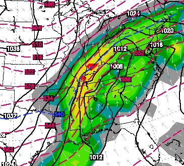
Snow, ice and rain will all be possible across Kentucky. We are a week away from that happening, so it’s impossible to tell you which on will be the main precipitation type. There is likely to be a lot of whatever falls and this should be a big ticket weather item for a lot of the country.
The European Model then follows that up with another storm system by next weekend…
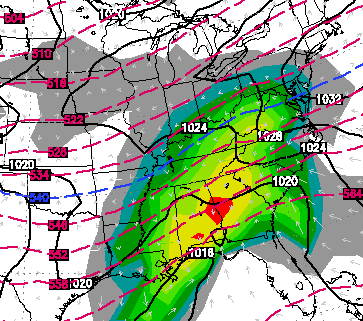 While specifics will have to be ironed out in the coming days… you get the idea of what I am talking about. The pattern is ripe for a lot of winter weather in February.
Enjoy your evening and take care.

Thanks Chris. Gonna just grab hold and hang on for the ride! Have a good evening everyone.
So it looks like instead of snow days next week it will be flood days which is a good thing they will miss less because of floods as opposed to snow/ice. Knox County has been out since the 17th and probably will not go any this week.
GFS has A LOT of ice in Lexington, 12z run had 2.4″ of ICE and the most recent 18z has 1.1″ of ice!!! The GFS has been trending weaker and weaker, which is good news since it has us in the icy sector anyway. I will be looking forward to the next couple of days of model runs and by the weekend we’ll know for sure if this will have a significant impact wintry-wise snow or ice. (And BTW GFS snow amounts: 12z 0.8″ 18z 0.3″ not good for snow lovers.)
Cobb Data Table QPF measurements for next weeks storm for Louisville are 1.55″ of rain, with temps in the low to mid 30s (above freezing) throughout the storm. Maybe a dusting of frozen precip after the front goes through. The same model six hours earlier, had 1.27″ of total QPF, with 6.1″ of snow for Louisville. Lots of flipping and flopping. We’ll see what the models have to say once the storm is CONUS and properly sampled.
thank you Chris.
I’m gonna hold out hope for a good SNOW from one of these big ‘uns.
Good tracking time to all!
Guess I’ll have to put off buying that new motorcycle until spring. Oh well, can spend a couple of months working on my line beard and watching some hot volleyball action.
U might consider a snowmobile instead. CB has been hinting at the potential for a lot of winter in February. Perhaps your….eh….”significant other” will really be impressed 😉 .
NWS forecasts for Frankfort Saturday nite is 70% chance of sleet and snow temp 31??
majority of this is going to be rain
I gave up trusting anything coming out of Dixie.
Moonpies!
The Euro has the best track for us (obviously) and it’s usually a very good model in this time frame. The GFS, on the other hand, has the track that most often occurs in our region. If the Euro were to hold strong and the Canadian were to move towards the Euro, then we might have something. All in all, I think model snowfall maps should be held in private so we can’t set ourselves up for disappointment!
I hope we get over a foot of snow. I miss the old school snows we used to get.
This is what, six days out? Right?
Didn’t back in ’93 all weather mets saw the super storm coming a week in advance? And it hit almost exactly as if they said it would, from a week away, back in 1993…Over 20 years ago! And I don’t think the storm could have been “sampled” 7 days out.
Sandy and the 2011 Superoutbreak did the same thing. But, those were exceptions.
Everyone keeps bringing up this ’93 storm…WHAT ’93 storm???! Unless it’s something that occurred east of ME (I’m in Nelson Co/Bardstown) I have NO CLUE??! Heck, we never get crap around here anyhow..?! Oh, yeah…I forgot…the ICE!!!? 🙁
While there were a couple of snow events that year, the March 13 (roughly) Superstorm/blizzard is the one that stands out by far, the one I will tell my grandchildren about.
http://en.wikipedia.org/wiki/1993_Storm_of_the_Century
I was a kid in Morristown TN at the time, got about two feet of snow not including drifts. I recall Lexington got only a few inches but it was still blizzard conditions (the SEC Tournament was ongoing at Rupp, but our power was out so we listened via radio). I understand Louisville got hardly any snow, so Bardstown may have been relatively untouched.
It was the definitive storm of the century. I don’t expect I will ever see another one like that. http://en.wikipedia.org/wiki/1993_Storm_of_the_Century
oops, I see you already posty a wiki link Mark. 😉
I lived in Knoxville during the Blizzard of ’93. It spoiled me!!! I love snow!!
Lexington and Richmond and places north and south got well over a foot of snow from that event and 75 was shut for two days. Not sure where you got a few inches from, but add about 10″ to your total 😉
According to historical records, Lexington was in the 1-4/4-10 inch range. So, adding 10 inches to anything would be wrong. Lay off the alcohol, dude.
It apparently depended where in Lexington you were. Seems logical that there were great variations from southeast Lex to northwest Lex. In this link, CB says from 3 to 12 inches in Lexington.
https://kyweathercenter.com/?p=8992
But as the maps shows, I-75 north to northern Ohio had very little snow.
Wrong link,
https://kyweathercenter.com/?p=6169
Indy to Chicago has been the sweet spot all winter and they will probably get richer in the next 7-10 days while we go back to rain and backside flurries, some of those place will be over 5 feet of snow for the winter while we have our 2-10 inch totals across most of KY, I know some spots have done much better than that but those are isolated!
May have to go visit my aunt and uncle in Bloomington IN then.
Please don’t say Chicago I have to fly there for business Monday 🙁
I just don’t see it moving in the direction that we need for a big snow event. All of our “near” misses start out with us in the sweet spot and move north. These maps don’t have us in the sweet spot, so why would this move in the opposite direction that they normally do. I’m with Andy. Better chance of a flood than an old school snow.
I enjoy reading this site. I also enjoy following John Belski at wlky website in louisville. Check out his blog tonight. He posted some of the computer models as well. This will be a fun storm.
CB,
I am playing psycho-analyst (or is that psychotic analyst?) here and reading into your words and “thoughts”:
You perhaps think this has big ice potential and do not want to get folks in a panic, since it would be Icemageddon and likely set us back to the dark ages for a while. If you thought it had a decent chance of being a good snow maker you would say it, since not traumatic like a mega chunga, women and children first ice event.
Since a mega snow seems as likely as our Cats this season winning a road game against a good team, guess I will hope the system is weaker, or mainly rain. Least of the evils for most.
We are all watching the wx models and hoping that the middle of next week won’t bring an ice storm. Of course, much better snow or rain.
Today happens to be the anniversary of the 1951 ice storm that brought Nashville to its knees…..or perhaps more accurately, flat on its back 🙁 .
http://www.srh.noaa.gov/ohx/?n=1951icestorm
Perhaps one of the few good things from this storm was that nine months later, the birthrate skyrocketed 🙂 . A lot of snow babies, or in this case, ice babies 😉 .
One can only hope that don’t happen here.
Sad to say but i doubt if we ever see anything like that for the rest of our lifetime..I wish i was never born to witness such a magnificent storm..Only make’s me foam from the mouth each winter wanting to taste another…Oh by the way this post is for Barb..
Can anybody say where high pressures will be located during next weeks potential snow storm?
Marc-Weinberg on Fox41 basically just said, don’t pay attention to the hype machine and be ready for nothing but heavy rain next Tues/Wed.
This is an excerpt from what he said
The GFS solution that is warmer to me seems to be the most likely solution at this point. This means I think it is more likely that we get heavy rain for our area right now. Central Indiana appears to be a greatest risk for a big snow as things stand right now and that still is VERY uncertain.
Hope you will hold him to that definitive statement.
Interesting statement there CB!
I still remember the US Winter Outlook, with normal temperatures and precipitation… Ready to measure whatever comes our way. I am hoping whatever way we swing, we try to avoid any major ice with it, and Utilities say operational for most.
Hey, some I read were even calling for it being warmer than normal. Especially in January. I am positive it was not warm.
And I am with you and others on the no ice. I have been here for some ice and long term power outages, no thank you to that.
Honestly, if Chris didn’t post models, this blog wouldn’t be nearly as fun! Gives us a bunch to talk about! I really do hope we get a big ol snow, I’m good on the ice, way to many bad experiences with that! Lol