Good Thursday, everyone. I want to say a big hello to all the new folks who found us over the past few days. Wednesday as the most traffic in the history of the site and that’s saying something. Here’s hoping the new folks will join in on our conversation about all things Kentucky weather.
Let’s start with where we are today and foll forward…
Our day starts with readings in the single digits under clear skies. We will hit the freezing mark for the first time this week later today. Highs will hit the low and middle 30s under partly sunny skies. High clouds stream in late in the day.
Those clouds are ahead of milder air that works in for Friday as temps try to hit 40 degrees. A shower or two will be possible as the day wears on. That action will increase for Saturday as temps spike well into the 40s. This is ahead of a cold front that surges eastward for Super Bowl Sunday.
Colder air catches the precipitation and will mean a light mix or some light snow early in the day. Check out the progression from the GFS model…
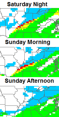 The same model run tires to put a little light snow down across parts of the state…
Temps for those Super Bowl parties should be in the upper 20s.
From there, it’s all eyes on the storm rolling our way for the middle of next week. This system will be loaded with moisture and may bring a nasty mix of rain, snow and ice to the state. How much we get of each is still a long way from being determined.
Most of that will depend on the track of the low pressure. One scenario would keep the low skirting by to our south and east…
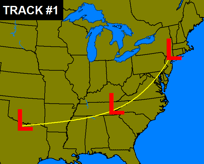
A track like that would put our region in line for significant amounts of snow and ice. The GFS is really hitting the icing potential right now…
The other track would cut the storm right on top of us and into the Great Lakes. That would be a big time rain maker that ends with snow and ice for the region…
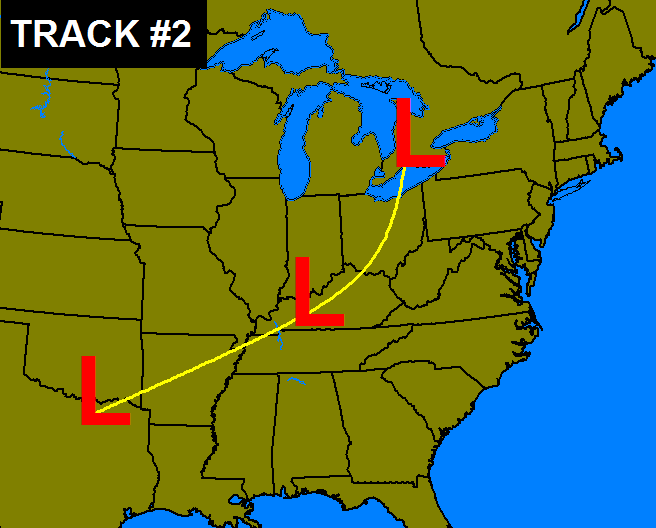
Those are not the only two options, but I don’t have enough space to make maps for all of them. 🙂
Another system is likely to follow that up by the end of the week or into the following weekend.
I will have updates coming your way later today. Make it a good one and take care.

Things are gonna be very interesting over the next few days. Thanks CB
I am putting $20 to win on option 2.
Remember there are also tracks 4 5 and 6.
And sub-tracks 4a, 4b, 4c, 5a, 5b, 5c…
Out of the 2 possible tracks you posted CB. Which one would be more possible
Lakes cutter with a low moving right over Kentucky seems to always be the most likely path with any storm moving this direction from the southwest.
Thanks, Chris!
I want snow!!!!!!! No ice or rain! Lol
I see rain south and southeast
From mid jsckson co to about little north lexington, mix to ice. Further north, more ice
North of lexington to ohio river ice to snow, more snow on northern parts
If you were to believe that run of the Euro almost the whole country would be covered in snow in the next 10 days except the Gulf Coast. Southeast Kentucky covered in 2ft. I think the second storm towards next weekend is the one to watch. The storm that everyone is talking about now is trending somewhat weaker with each run.
Chris
you always do a wonderful job witht he weather, I do have a question for you. on Wkyt weather page you said then things get closer to normal. You do you mean by closer to normal and what is normal for this time of the year? .
Thanks Bluedoc
With the NAO climbing higher into positive territory in the short-term, I would tend to lean toward option #2, considering the lack of blocking in the North Atlantic.
You might want to consider the warmth of the water in the Pacific ocean. There has been above average ocean temps in the Pacific especially off the coast of Alaska which is pumping up this Alaskan Ridge. This will help force lows on a more southerly track. If it holds, we could see a couple of good snows, especially if the low is not particularly strong.
That being said, This doesn’t look like one of them. Could someone explain to me how one would get ice from the last couple of runs of the GFS? I guess low level cold air will stay in place?
This year has been quite an educational experience, for sure. The -NAO has not been there for us, but the Pacific has trumped it. That being said, the PNA, which had recently been positive, is now trending negative. We are losing the strong eastern trough which has dominated the pattern lately, so a westerly track seems more possible.
“Most traffic in the history of the site”. . . Well I’m glad people are finally getting smart and realizing you are THE place to go for accurate weather! Way to go weatherdude! 🙂
/agrees with what Erin said
Either track would mean flooding rain for SE Ky
Yep…get out the ark. 2-4 inches of rain, at least.
Yep, might as well get on board folks. You guys farther north my get in on the gold ole flooding rain as well. We her in the South will gladly share our misery! 😉
Since mainly snow for most of Kentucky is not looking good, I will cherry pick the model with mainly rain, since the least of the outlook evils.
Track #2 definitely, guys, no worries for an ice event, all models trending warmer and I expect it to continue, I actually dont even think there will be any wintry precip with this. Go home, snow lovers, nothing to see here, just some good ‘ol heavy rain.
100% agree
Looks to me like we’re going to get the typical 33-35 degree rain with this storm… :\
I believe it will all depend on how strong the Southeast ridge becomes in the next few days. If not as strong the low will track more easterly out of the south. With a cold air push Sunday into Monday this COULD set Ky up for a major winter storm for most. If the ridge becomes as strong as it was back at the beginning of Jan. then the low will track more over Ky with most getting cold rain to ice with little snow. Flooding rains for the south. The cards will be on the table it just depends in what hand we are dealt. As CB stated there are more tracks than what we see above. Thanks for the update CB.
I see you understand what is going on here. Models are not picking up on the high pressure building in the east as this plays out. Nice to see someone think about what is going on other than using models. Good comment…
Models were not kind last night to Ky…Look’s like way way North on latest modeling..Put a fork in this one..Unless we get divine intervention for a 800 mile shift South East..
Which is fine with me i would rather not have flooding rains on top of frozen ground. The kids have missed enough school.
Agreed….High Pressure off the cost of FL/GA will push this low right over us. I will say that I am 100% certain that all of KY will see only rain out of the Tue/Wed system. I flipped like the models within an hour of my previous reply. Don’t you just love winter in KY??????
THINK RAIN!!!
have you been possessed by Rolo? 😉
If this GLOBAL WARMING continues, we’re all going to freeze to death!!!
Hmm, i don’t think you can see the whole entire world through your living room window?
The last Euro looses “almost” all snow for KY. Surprise, surprise.
temps in London tomorrow supposed to be sunny and 52, Saturday supposed to be sunny and 56, probably will hit 60 … amazing how 2 nice days gets overshadowed by a storm that may give us nothing.
You may have answered this before. I was wondering why the WKYT weather app usually does not match your predictions. Does the app forecast come from somewhere else? I just rely on your posts because your forecasts are the most accurate.
thanks Chris. heard Matt mention you on KSR yesterday. pretty cool!
great to see all the mets on here with the early predictions- I gotta think we’ll get a good SNOW this season.
Oh my all this will make your head spin, I really hope we don’t get heavy rains on top of frozen ground. That would create hardship for a lot of people. This winter has been full of surprises. But thanks to Mr. C Bailey we have not been as surprised as most. Thanks so much for all the info and keeping us on top of things.
Thanks Chris. Lets hope we get option #1, as it means big time snow. Would not wish ice on ANYONE. But we will see. I tend to be of the mindset that we will get a good snow at some point. Will this storm be the one? Only time will tell…..Have a great Thursday, everyone. Enjoy the sunshine On another note..today is the first day in over a week that I have not had to wear long johns to work!
Negativity dominating the board early on! I’m feeling the same ol’, same ol’ too but with this winter ya never can tell what’s going to happen. Still way too far out to say what will happen either way.
Models are flip flopping not a SURPRIZE, so tommorrow they flip the other way, yes rain is the most likely event but one never knows until a day or so before the actual storm, reading all these amateur forecast is entertaining though, and I’m sure Chris gets a chuckle to 🙂
Looks like accuweather is starting to get on board with what Chris was talking about first of January – cold hangs on all way to March
http://www.accuweather.com/en/weather-news/spring-outlook-six-more-weeks/22312537
Hate to see that. Utility bills already high and will be outrageous next year. They look for anything for a rate hike and this cold will let them raise it x2 next year.
Listening to KSR talking about the Royal Snow Rumble. Bailey vs. Meck cage match. Oh Yeah!!!
From the NWS Weather Prediction Center in Maryland, the blend of models suggest to them, AT THIS TIME (as things will likely change), more of a heavy rain threat for most of Kentucky. Areas along the Ohio River could get some icing. This is just one thought, not saying this will happen.
I’ll be studying the 12z Euro run next.
There was a moment, just a moment though, when I thought I might actually snow here next week. Clearly, it was a moment of weakness and I apologize!
rain next week, then lok for SNOW afterwards
there going be 2 major storms next week for the coiuntry
No one here should discount anything yet. Models almost always flip flop until it is just days away. We have time. Chris does such a great job giving us info and his thoughts about potential storms. But remember it is not an exact science and when models show something significant 5-7 days out it is understood that yes, something potential is out there, but it it is still only a trend until it gets closer.
“The trend is your friend.” 😉
My new rule for wintertime precipitation in Kentucky:
If it has a chance of being either rain or snow, it will be rain nine times out of ten.
Welcome to all the new readers of the KWC blog. Please don’t be discouraged by all of the negativity posted by the countless people on the comments section. If you stay here long enough you will soon learn to scroll past most of it. The comments can be good when information such as weather models, local information about storms, and historical information is shared among members. However, when some areas see a lack of snow people tend to get a little cranky and think they are a certified meteorologist who can predict the weather a week away with 100% accuracy. It’s kind of like a mix between a Holiday Inn Expess and Snickers commercial. With that being said, we think you will enjoy your stay here at KWC and hope to see you back often.
Yes because Big Papa is our “expert” and only his opinion matters.
Well i would rather take my chances with a system to our south trending North instead of opposite..The low would have to start jogging a lot to the SE for any real chance at frozen precip..Then you still have to worry about warm air if did take a SE track..It’s currently modeled from AlaBamie to Cinn..But in the world of weather you never know..Stay tuned..
Gonna be close call for Kentucky, as usual. Would think AT THIS POINT, southeast KY gonna be mostly rain. Lexington area: mostly rain, snow on end. Anywhere north and west of Lexington: could be anything. Models will wobble around through Monday.
A friend in Ohio, Greenville…..Granted they have a big home, but their electric bill was 600 dollars!!!!!! Mine was 185…..but house is smaller….even still, I’m sure the next bill will be outrageous and I keep heat on 65 (electric heat pump)
Wait until some people from EKY chime in with their electric bill stories since you posted that. I’ve seen some outrageous $ amounts on facebook
My last bill was 107 🙂
Here in my school, everybody is talking about a foot or two of snow next week and an ice storm, is that true? I would love some more snow days!
Happy to have found you again! My husband,kids & I were completely addicted to your blog when you were at WSAZ. You are missed!