Good Thursday afternoon, gang. We have a lot of action to track over the next few weeks and none of these systems can be taken for granted. For instance… the models are trying to key in on a stronger snow system for Sunday night.
The NAM only goes out through Sunday evening, but you can see moisture streaming in from the southwest…
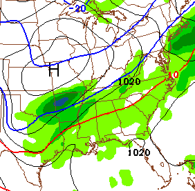
The new Canadian Model is very aggressive…
We really need to watch that system for the potential it ramps up a little more. That is ahead of the storm system that everyone’s talking about coming for the middle of next week. It’s still way too early to determine what that system brings to where you live. Rain, ice and snow are all a possibility and it could be any combo of the 3.
Anyone making declarative statements on exactly how that plays out has no business in this business.
By the way… check out the system that comes after that storm…
That may arrive by the end of next week into the weekend. Make it a great day and take care.

Thanks Chris! Now we need the Sunday Nighter to ramp up, pulling in the cold air, setting the stage for next weeks fun and games LOL!
Cool call – Snowman!
Thanks Chris…should be big fun tracking these systems.
Congrats to Matt Elam & the Cats!
yahtzee
Another Louisville MET (WLKY Matt M.) just told everyone they need to calm down all the hype on Tuesday/Wednesday storm, as that is all it is (hype)! He went on to say, with all the weather blogs and social media outlets out there, people tend to get overexcited and misinformed, lol.
He said we may have some back end snow. But, just like Fox-41 and now Wave-3, he is saying mostly a rainmaker. Although, Wave-3 is concerned with ice.
Well, they all “may” be correct. But, as Mr. Bailey just said “Anyone making declarative statements on exactly how that plays out has no business in this business.”
I do agree with someone with an earlier post, which is I am very interested in what the storm AFTER this mid-week storm, does. It has major potential. I really don’t think next weekend’s storm will be a lakes cutter. Not that I’m completely sold on the upcoming one cutting either. We shall see.
All in all, CB was right on the money a week ago, when he said there is lots of winter left and at least 2 big ticket snows that will affect Kentucky in February. Keep the faith everyone. I really do believe all the snow lovers will be quite happy by the end of February. 🙂
I think a lot of these guys simply don’t like the public having access to model data. They want to be the keepers of it.
Makes sense, when one of them says “that’s why WE do the meteorology side of forecasting and don’t try to overreact to model data.”
Thanks for the updates Chris, this why you are the best during winter weather events, you don’t base your thoughts on one run of the Models, looks interesting in the coming days!
I LIKE the hype and getting overexcited! That’s why I come here to read Chris’s and your all’s thoughts. My wife thinks its sad that I have to zero-in other people’s weather or worse yet….relive exciting weather events from decades ago, LOL.
Bjenks, you better get your salt pile built up.
Thanks….still have around 600 lbs. Hopefully that is down to 300 after the Sunday system. Would really like it all gone so I can wash the truck. Oh wait the rain next week will take care of it….ha ha
Imthink local guys threw shots saying someone cslled for 1 to 2 feet snow on social media. chris was accused of starting that one, ive never heard chris say a forcast for 1 to 2 feet of snow. I still think rain for mid jackson co south, mix to ice from mid jackson co to a tad north of lexington, from tad above lexington to ohio river ice to snow more snow more north you go.
A weather caster from lex 18 said ‘someone’ in their business claimed to forecast 1-2 ft of snow,I even asked on that comment ‘who’ they were referring to but they wont answer anything but vague comments. I have never seen Chris say it either ,also didnt hear it on the news. I did see another blogger on here say someone ‘said’ it .I say if your gonna blame someone then own up to who your talking about or keep quiet ! I do listen to other weather but to be honest this is my go to blog for accurate weather,thank you Chris for all you do !
Sunday night looking like it might get dicey. I bet a lot of people (in teaching) wouldn’t be too upset missing school the day after the Super Bowl!
Thanks Chris you are the best.This 30 degrees feels pretty good today.Hope everyone has a great day.
Typical 38 degrees and rain. Nothing to see here.
Thanks Chris for all you do. Sounds like its going to be another interesting week. Just hope its not ice, rather have snow any day.
the end of the week system has a little more potential but for now it looks like what we had before the Polar Vortex for SE Ky
Looks like the last 15+ years Andy. On the borderline again and we know how that has worked out. Not even close to being in play for us down here. All the week out systems usually head the opposite direction. A “week out” system would have to start out with middle TN in the sweet spot for us to get in on the action. At least that is how the models have performed in the last few years.
I believe the last time a gulf low actually delivered significant snow to central Kentucky (Lex) was late December 2012 where 2-3″ fell.
One of my work colleagues had business with a client near Vanderbilt a short while ago. She saw at least two Vandy students wearing short pants!!
Yep, after near zero temps, 30s (currently 35 in Nashville) seem like a heat wave 😉 !
They probably didn’t have any other clean clothes haha
My son wears shorts everyday. Period. Even in this polar vortex (Louisville). He hates jeans. He shovels show in shorts. Whatever . . . as long as he doesn’t complain about being cold. I make him keep sweats in the car in case we breakdown on the way to school (Etown)
Brave boy! I was just reminded of the never ending laundry bag that was brought home, didn’t know you could expand those things that much 😉
Thanks Chris..I know you will help to keep us on top of this. Thursday Feb 6 and 7 I will have family at Vandy hospital for important tests. So I know as soon as you know about next week you will inform us. Thanks for all you do 🙂
Hmmmmm…Traveling to Indy over the weekend. Forecast there is for snow and freezing rain Fri/Sat. Drive home Sunday evening and throw salt for Sun/Mon system. Sounds like a great weekend of wintery conditions.
Thanks for the update Chris…hopefully everything comes back around to a good ole thumping next week.
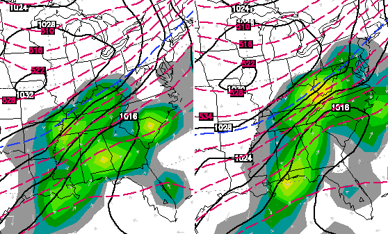
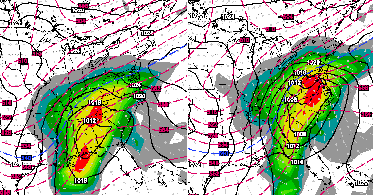
It looks like the first big storm will be a flooding rain maker for Kentucky. It looks like the storm that follows will be a storm that moves to our south and then turns up the coast to deliver a big noreaster.
There’s a reason we get so little snow. The Appalachian Mountains act as a big block.
It will be all rain on tuesday’s system. Now I wait for Big Papa to say not to listen to us “armchair” mets. But if you go with the trend that’s what happens 90% of the time.
My point being is that with the models the way they are they can and probably will flip flop five times over the next five days and in no way can you all “armchair mets” predict what is going to happen a week away. You are just being negative like always and contradicting everything CB says. Trend or no trend you cannot accurately predict any weather a week away like you are claiming you can.
Agree, models are used as guidance only more than a couple days out!
I will say if you want snow next week hope that the storm Sunday nite lays down snow cover across ky because that would most likely shift next weeks storm further south!
All the times I had publicly called for rain on this blog it rained. I’m not downing Chris at all. If I didnt like Chris’ forecasts I wouldn’t come to this blog. If you tell me that I don’t have a clue you have to say the same about EVERY met because they don’t know either.
That’s true and the reason why CB isn’t saying it’s going to be all snow, or all rain, or all ice. He’s giving us the models and how it’s tracking at this moment. He never gives us his forecast this far out. No smart met would do that. Only armchair mets who think they know it all and want to sound smart do that.
I did explain that due to the trend, that’s why I called rain. No hard feelings. It’s all gravy baby
Thanks Chris. Let the fun and games begin!
Dodger says we’d best get some big snow from one of these three chances because winter storms this season are about to be over! Dodger thinks 3rd storm is the one!
Thing is with all these systems coming is that I could get on here & bloviate about how “they’re all gonna be rain with backside snow, blah, blah, blah…” – and more times than not it would look like sage, seasoned wisdom simply because the weather patterns around here favor that kind of system more often than not. But no one comes on here to hear what I think based on what the odds have shown, and Bailey’s right – I don’t want meteorologists making long term forecasts based on that kind of thinking, either. That’s how you get a 23-inch dusting. My takeaway from this is we’ve got potential for something to develop in the next 2 weeks that we will have to be aware of & prepare for.
Thanks for keeping us posted, Mr. B. Let the model-watching begin!
“That’s how you get a 23-inch dusting.”
That would be so sweet. And a lot of (snow) dust.
Yeah, I usually use this information to have an idea of what is lurking. Chris does a great job of putting out information. And if anything this year has not been trendy. So I would say anything could happen. Of course that is always true with the weather from more than a few days out.
See, this is where I disagree with everyone. I do come here to see your thoughts. Chris gives us his thoughts, and great weight should be applied to those. But at one time it was fun to come here and see the discussion between us “arm-chair” mets and learn a few things in the process. Then it devolved into I want off school vs Bashing Chris vs Bashing NWS.
I learned a long time ago that when these things come from the gulf you have to watch for warm air to be pulled in to the south east corner of the low. I also learned how to read those maps and charts better to see what the “blue” line means.
We have lost that because of all of the bickering from all sides. I know Chris personally and I don’t think that is what he wants. I think he enjoys the discussion as long as it is civil. I will always fall back to Chris’s forecast. It is the only one I watch. But his official forcast on the news vs his blog where he dumps out what he sees as possible coming up are two different things.
I like it when everyone gives their reasons for what they see. It is fun and great weather discussion. But I am always going to fall back to his official forcast (along with NWS Jackson) as they know way more about this than I. But it is fun to speculate.
I agree 100%. I like seeing other people’s predictions and when certain people tell us to stop with our armchair forecasts, I get aggravated.
Here in my school, everybody is talking about a foot or two of snow next week and an ice storm, is that true? I would love some more snow days! My teacher asked who reads CB’s weather blog and surprisingly, about half or a little more said they do in my high school.
Only snow worth mentioning IMO will be north and west of Lexington based on past trends
i guess its not reasonable to have had one of these moisture filled storms to come by while the arctic air was here …
Only problem with these backside snow storms the last decade is that their not only backside they are “tail end” backside. Most of the old school storms start with rain with a quick turn to snow. Problem is we haven’t gotten that quick turn to snow. All we are getting from them is lots of rain and once most of the moisture is gone, a little bit of snow. The above models look similar to a lot of other storms the last decade that brought very little snow. Maybe the trend will change,
Didn’t the 23 inch dusting in 1998 start out as rain?
Like I said above, most “Old School” storms start as rain and quickly turn to snow. The turnover to snow has been very slow the last decade. For some reason the warm air just doesn’t want to get out of here. Why it did in the past, I do not know. A few years ago we had an “old school” showing on the models just hours before the storm. Up to a foot of snow supposed to hit in some areas in Eastern and Southern KY. I think Lexington ended up with 4 or 5 inches and nothing but a dusting below Rockastle Co. Almost the entire event south of Rockcastle stayed rain with very little backside snow.
If it wasnt for the clippers and backside snows, we wouldnt average 2 inches of snow a year here. We never get any direct hits anymore.
“…no business in this business.” Love it! I thoroughly enjoy this site and look at it multiple times a day. Thanks for preparing such interesting and informative posts on a daily basis.
Just imagine how long the snow would’ve been on the ground if it had not melted sunday, it would’ve been there for two weeks! And melt by heavy rain with a lot of flash flooding because of rain and melting snow.
Hhhhmmm???? Superbowl Sunday? Dusting????
I understand all of the negative nancies on rain changing to snow storms but facts are that is the events that bring us the biggest snows. The superstorm sandy was only forecasted for a dusting here in charleston, woke up the next morning to 10 inches and no power. Trust me one of these will deliver.
That’s a intersting run from the 18z nam for Sunday.
Just wanted to let you know Chris. You and the WKYT crew is the only ones I listen too!!!!! Don’t know how to read the models that you post but I love reading your blog!!!
I just started looking at you site and Love it. I had a friend on facebook tag your site and now I dont look at the local site anymore.
I keep hearing about these 12-18 inch snows by middle of next week, But yet no one can tell me who is putting out these numbers. Please help expose all scrubs of the meteorological world by posting names and network affiliations of those who choose to do as Chris says, make definitive statements on storms a week in advance.
Thanks
This is what happens when model maps are shown well in advance. Chris posted some here. The problem is that people see what they want to see and things get blown out of proportion. What’s funny is all the backtracking the mets are doing on all channels while not blaming others. Guilty consciousness’ I suppose.
I don’t believe any met (Chris or other) has said anything about totals. Someone posted here a couple of days ago that a run of the Euro model at that time “looked” as though KY could be hit with up to 2 feet of snow. I think that post is where all the chatter has come from. Obviously the Euro has now changed its tune in the last 3 runs.
Ohio is planning for the worst to the point I have to make some preliminary plans for product supplies to markets in the region that get stuff from them. They are expecting a complete shutdown- IF the system pans out as trending.
Better safe than sorry.
Chris,
I’d like to get some feedback about what you think about the several inches of snowfall in Arkansas Saturday night and how that snowpack will influence the track of the low Monday & Tuesday? Todays trend has the low going right over central KY but im thinking a snowpack that far south will shift it more east. Am I correct in this thinking?
We’ll our snow pack ground of several in last sat. Didn’t keep the SW winds moving right on us with temps hitting almost 50 on Sunday… So for my thought, that wouldn’t have an affect on the low
CB,
The common tale at work today was there was a 15″ + inch snow coming to Kentucky next week. When I suggested it is more likely to be a Ohio river on north event and perhaps mainly rain with some back-end frozen stuff here, I was treated like a heretic.
Funny how rumors grow to silly levels.
But you always say that! Like me
Two days ago kyt had rain on sat but 39… Now has 50!
Just have to wonder bout the other lows?
I would like to know what the colors mean on the maps you show.
Thanks!
If everyone would go to the post under Extreme Pattern Continues, Jan. 26, Chris posted a map from the GFS about snow POTENTIAL for the first 10 days of February, it shows Eastern Kentucky in a 24″ range, he also stated this is just for FUN. I think this is where everyone is saying that Chris said Kentucky was going to get 2 feet of snow.
Anyone else seeing the mess and public outcry today about Atlanta not being prepared for the 2.5″ of snow they received earlier this week? OMG people! It’s hard to believe residents didn’t have an idea they were going to get snow. It was only talked about for three days prior to happening. Unbelievable.
that’s probably what would happen if southern ky got that much snow
I don’t think it was the snow that shut them down. It was the unexpected ice that arrived prior to the snow. All the people were leaving metro Atlanta and got on the roads and then the ice hit. Nothing they could do. However, I do think that action could have been taken more promptly.
Thanks Chris for keeping us informed. It’s nice to know what could happen, but I always wait for your forecast to know for sure and never pay much attention to what anyone else’s opinion about the weather is.
A friend of mine sent me the link to this, and I’m loving it! I’m a weather junkie, still reeling from the loss of The Weather Channel due to DirecTV, so this is a Godsend!