Good Thursday evening, gang. Here’s hoping this update finds each of you doing fantabulous! I keep hearing about some of the other folks in town trying to stir up some fake weather drama. Did I mention today is the first day of TV ratings? I find it funny, but do extend a big thanks for all the new hits and viewers they are sending our way. 😉
I don’t have time for drama and will just keep grinding and focusing on the weather. 🙂
Let’s start with the half and half weather weekend that’s ahead of us. Saturday is looking better and better the closer we get. The showers may hold off until the evening and overnight and that will allow temps to head toward 50 degrees!! Yep… I’m ready for that!
The cold front swings in with rain late Saturday evening into Saturday night. This could have a mixed bag of weather sweeping eastward behind it. All indications are a wave of low pressure will develop along the front late Sunday into Sunday night. The NAM is really amped up…
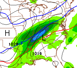
The European Model is a bit farther southeast with the track…
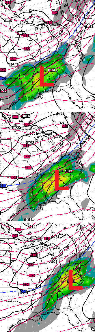
Either way… if that low does develop, a band of accumulating snow would be possible somewhere across our part of the world.
I have no changes on my thoughts for the storm for the middle of next week. Rain, ice, snow or a combo of the three will be possible. It is still too early for anyone to get more specific than that. We’ve all watched models flip and flop with this system and with every system through the years. That’s just how things roll.
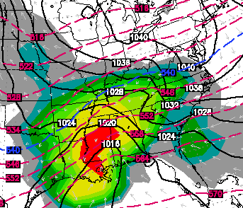
Speaking of rolling… check out another storm that tries to develop by next Friday…
Enjoy the evening and take care.

well that secondary low sunday night could be interesting
Thanks Chris. Have a great evening all.
Well if SE KY is going to get any snow to amount to anything it will have to be Friday’s system
Yep–I saw the drama–on the air and on facebook. I don’t think people understand all the time that this blog is NOT a forecast most of the time. It is a “heads-up” on what the pattern might produce. By the way, I thought this blog had a potential low moving right over Louisville as “Track #2.” Which would bring mostly rain to Kentucky.
It seems as likely we will have mostly rain as Ohio level on up might get ice and heaps of snow.
It did… but certain people are cherry picking. 🙂
Hey, I cherry pick. I like to cherry pick my information right from this blog. And yes, I understand it is not a forecast. It is a look at the possibilities coming.
I, like many others here, appreciate the information you provide. And to tell you the truth your outlook actually helped me plan for upcoming weather that did end up happening that nowhere else was calling for at first.
I do like me some cherry cobbler. Thanks CB for all you do for us. I do like the weather discussion on your blog very much. Always giving us something to look forward to no matter the type of precipitation. I travel a lot,so this is my first stop of the day for my weather information.
Sure is a lot of hoopla over a tiny possible Sunday snow and a bunch of likely rain for all but the Ohio river on up. Even that is still a guess, but WAY higher odds than south of that.
Honestly, I have some hoopla over that snow. My one lane road is a mess when we get much snow. Have to cross over a fairly steep hill (sure many others have things like that to deal with) and cannot do that without the 4×4. So I usually plan to park my van out so it is not stuck in here.
Chris thank you for all the hard work you do in keeping us updated on the weather.
This will end up the coldest month across Kentucky since December of 2000. Hard to believe January of 1977 was actually 9 degrees colder than this month! That must have been brutal!
It was and I loved every minute of it at age 14, this winter is just a pretender compared to that winter 😉
Yeah, this is nothing compared to that year. Belski has a nice blog post up today about how it has been cold but nothing remarkable. Not even close to a top ten coldest January for Louisville and he reminds us that December actually came in above normal. I know that Lexington had a record low but no such thing here in Louisville. I suspect it’s just that it’s been so long since we had an old fashioned winter (14 years and thanks for that info) that many people either don’t remember or weren’t born the last time we had cold like this.
Jan 1977 was when it even snowed in Miami Beach and Homestead FL. While it snowed in Miami, it did so unofficially, as strangely the flakes did not fall at MIA airport (the official reporting station) even though it snowed in all directions around MIA. There was even a rain/snow mix at Freeport in the Bahamas. There were unofficial reports of brief snow with the rain at Key Largo FL.
Johnny Carson could not resist joking about the Miami snow in his monologue.
This was before I was born, but I have access to old issues of Weatherwise Magazine at various libraries. It’s like a time machine.
Thanks Chris for all your hard work! I just found this site a few weeks ago & have been hooked ever since!! I truly appreciate your informing us of these winter weather possibilities!
Fox 6 out of Alabama has tweeted a big snowstorm for Feb. 7.
As much as I love snow, I am ready for a normal school week. My kids have been out of school for two weeks pretty much for snow and water issues in Russell KY. I’m sure they won’t mind a few more days off but they will sure be singing a different tune come summer time!
Chris, I really appreciate your weather insights and all the information you post. I also follow another Louisville TV station blog. And I appreciate their insights and info as well. But I’m not interested in the recent banter about “other folks in town” stirring up “fake weather drama” (as well as the other folks’ responses to your suggestions in their own blogs). Maybe I don’t know who you’re talking about but I haven’t heard any hype. If you’re right and they are wrong more of us will turn to your site for our weather. Just saying… Really enjoy your site.
Today I was hit with a huge reality check..as I was driving down US 23, there was a semi tanker truck about 100 yards in front of me, going no less than 55..I watch a gray canry pull right out in from of him, absolutely getting pummeled. I couldn’t believe what I was seeing, I seriously thought I just watched someone die…I had a buddy with me, we pulled over and stopped the car, along with a few others and ran over to the mangled car, miraculously, by the grace of god, both woman were responsive and the driver ended up walking away…the point is, it doesn’t matter if it’s gonna snow 2 feet or I’ve or rain or whatever, just be glad you’re breathing and are able to enjoy this blog…there are some amazing people on here and i enjoy all of your comments! I just hope we all can understand that there is so much more to life..god bless you all
Very nice and well spoken comment Corey.
Amen!
This is the best comment I think I have ever read on here you are so right just need to be thankfully to be alive…
Is it just me seeing things, or did the 00z NAM just go completely psycho for Monday?
For snow I hope
hope others will be joining in the snow dance over the weekend! lets bring a great end to the winter season and snow it up real good!