Good Friday, folks. The weekend is just about it and it’s no ordinary weekend… it’s Super Bowl Weekend. It’s the closest thing being a national holiday without actually having the distinction of being called one. Hot wings will be flying, but will we see any snowflakes doing the same? That’s becoming more of a possibility for late Super Bowl Sunday night.
Let’s start out by talking about the positive side of the forecast. The weather today into Saturday looks pretty darn good with highs well into the 40s today with a mix of sun and clouds. Saturday is likely to see gusty southwesterly winds boost thermometers into the 50s.
Most of the time will be dry, but I can’t rule our a shower or two trying to pop across central and western parts of the state.
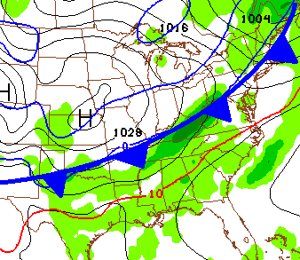
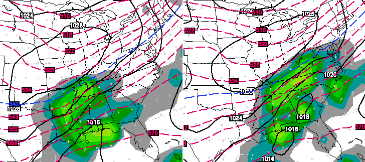
A cold front will then slowly cross the state from west to east Saturday night into Sunday morning. Shower sill increase ahead of this front and the cold air coming in behind it could mean a bit of a mix developing early Sunday. Here’s where the front looks to be during that time…
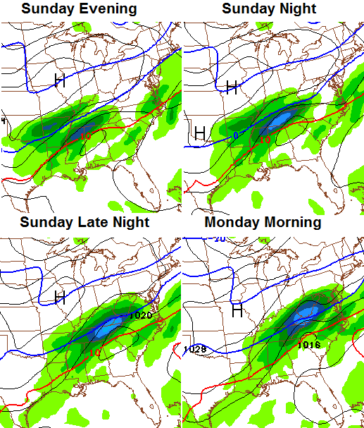
 That front will slowly push eastward as the day wears on. A break in the precipitation is likely during the afternoon, but many of the models are developing a wave of low pressure along the boundary. The NAM model is among the most aggressive of the bunch with this…
That would bring a swath of accumulating snow across parts of the state. The highest chance appears to be across the south and southeast, but that is not a given. FOR FUN… here’s the NAM snowfall map through Monday Morning…
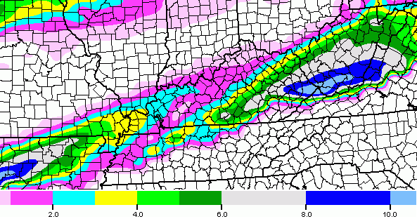
That is NOT a forecast… it’s a computer model forecast. That will change as the model gets a better handle on where that system tracks.
The new European Model also brings a swath of similar snows across the state…
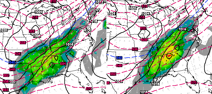
The Canadian Model…
Think about this for a minute… this is a system that wasn’t really showing up on any of the computer forecast models until the past 24 hours. Does that make you feel good about how the models are handling the Tuesday and Wednesday storm system?
That’s why I have been saying from day one that rain, ice, snow or a combo of the three could fall from that middle of the week storm. People can’t just latch onto one run of a model because it backs up what they want to happen or to back up a declarative forecast they foolishly made form a week away.
I hope to get a better idea on what comes from that storm as we get deeper into the weekend.
There will be no rest for the forecasting weary as another storm follows that up by next weekend. This is a pattern that will fire storm systems our way every couple of days over the next few weeks. One of these is likely to smack us with a decent snow before we get to the middle of the month. Look what happens then…
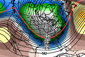
How about another arctic outbreak? That is, at least, a possibility down the road.
I will have more updates later in the day. Make it a great Friday and take care.

Hoping to finally get a decent snow in southeast ky
you guys look to be the hot spot for snow on Sunday night
Truthfully, the way the atmosphere is right now and for the next few week, everyone is in the hot spot, yet, they are not. Lol
What an intriguing weather month February is going to be. It just very well may send people off the cliff or at least age them by 5 years haha.
Blasphemy
That was for Robby
lol I know, I know… but seriously, if the track of the Sunday night storm drops, wouldn’t that seem to imply the next one would too?
Umm no and if i was a betting man i would bet on the trend as its been a sure thing
Thanks for the answer. What’s your basis of those thoughts?
Every system we have had that has had the “potential” to be a big ticket weather deal for the SE has ended up being 90% rain its been that way for quite some time including this year so i dont’ expect anything different.
Not arguing, but asking because you seem to be knowledgeable. Wouldn’t the change in tracks be seen as a new trend?
Please mister weather guy, don’t let that arctic outbreak visit us. I’m so very weary of this exceptionally cold winter. 🙂
In all seriousness, thanks for the honest forecasts.
Looks like a chance for heavy wet snow and no power
I can all but bet that won’t happen, I know have a generator and the house is wired for it, these two things will keep power outages away… LOL
We will probley get rain andy. But I cant complain I did see snow last weekend, and system before that.
I suppose Chris will have to stop posting the models snowfall outputs because there are some people taking as verbatim and saying thats Chris’s forecast for next week.
In spite of all the model waffles, the directional trend still appears to be what it has been showing: Mainly a frozen event for north of Ohio river and mainly rain south of it.
Way too general of course, but the theme still appears intact. If it were looking like mainly snow or even mega ice for Kentucky, CB would be mentioning it (to some degree).
Today is the Chinese New Year and is considered the harbinger of spring!
BubbaG, if this makes you feel any better, here was your winter forecast on April 25, 2013 at 8:35 pm “Write this down….. The is coming winter is going to be bad. Not saying snowy, but cold-bad. Not even I am pompous enough to suggest snow.”
https://kyweathercenter.com/?p=6549
Did exactly what you said, and for this exact purpose because I wanted to bring this up later. So far, you are 100% spot-on! Great winter forecast that is panning out how you said it so far!
Not even top 10 though but it has been colder than it has been for the past several years. Kudos to you Bubba
I remember that. Should have read “This” instead of The is. Lazy phone typer.
CB said the same thing later on, but blinked and revised to more snow 😉 We shall see 🙂
As long as no ice, I will be happy. No ice is the least of the evils for most.
Local mets in charleston say this January was our coldest since 1985. Almost two weeks with snow on the ground. Impressive winter so far.
At one time, I liked you Chris… I’m rethinking that now… As a matter of fact, there are some Referrees that I’m likeing better.. That puts you way down on my list…
06z NAM has dropped further into Tennessee putting northern East Tennessee and SE Kentucky, including Middlesboro in the path for heavy snow! This of course will change a dozen more times between now and then.
The 12z NAM takes the moisture even further south for Sunday night, but intensifies the snow chances for Sunday morning for a lot of us.
John Belski always posts interesting facts about winter.
Here is a link if anyone is interested. It is for Louisville specifically, as far as snow totals and temps. He gives top 10 all time and goes on to talk about how this is a bad winter for most, but not extreme, as the charts will show you.
He has Louisville at “officially” 14.1″ for the season so far. Although, NE Louisville is @ 19.6″ 🙂
http://m.wlky.com/weather/some-interesting-cold-weather-stats-for-this-winter/-/17432440/24196086/-/wu7e9d/-/index.html
By way of comparison, check out these totals for Chicago and snowfall:
Ten Snowiest Winters in Chicago History
1) 89.7″ in 1978-1979
2) 82.3″ in 1977-1978
3) 77″ in 1969-1970
4) 68.4″ in 1966-1967
5) 66.4″ in 1951-1952
6) 64.1″ in 1917-1918
7) 60.3″ in 2007-2008
8) 59.5″ in 1903-1904
8) 59.5″ in 1964-1965
10) 59.3″ in 1981-1982
I know it is Chicago…but, Louisville’s top all time snow for a winter, doesn’t even crack #10 for Chicago lol.
Louisville’s snowiest winter of 50.2″ and Lexington’s 53″ is still not enough to crack Minneapolis AVERAGE snowfall a year of 56″. Even Minneapolis LEAST snowiest winter had 14.2″, around Lexington’s average! Wanna know minneapolis most snowfall in a season? 98.6″!
98.6″. Wow. Do not ever want to see a snow like that here in my area. I would like to at least be able to get out of the house at least once in the winter.
Thanks Chris and happy Friday to all my fellow weather lovers (especially snow lovers) We are indeed a goofy bunch, and I love that about us. From what I read on here, most of us are willing to be optimists and hope for the best when it comes to snow. Personally, I still feel like we have a great shot at a big one before the winter is over. Will it happen? Don’t know, but I am looking at all the data Chris shows us, and can’t help but feel like our chances are pretty good.
As for the Sunday system, if that comes to fruition, that would be great, but still not a lot for my area. I really hope the mid week storm system punches us ALL with a big snow, and not a lot of cold rain and Ice. Keep the faith, peeps, our day will come….eventually! 😉
Have a GREAT Friday, everyone. Looking forward to your thoughts and updates Chris, as usual.
Thanks Chris for informing us on what MAY happen. To all of you out there complaining about armchair mets I am tired of the bashing towards them. If someone has there opinion on what he or she may think is going to happen RESPECT that decision and read on. No matter if they are right or wrong it is their opinion and does not affect you the least bit.
Now that we are moving into the second half of winter we could have some pretty wintery weather moving in. Snow chances will be on the increase for much of the northern half of the state this week into next. Another arctic outbreak for the third week of the month.
I agree Bjenks. The comment section used to be a lot better years ago. Actually ran off a few people that had fairly good skills in reading the maps. Even if they were not personally bashing CB the were accused of being haters. If they interpreted the latest data and it didn’t line up with CB’s last post , they would get blasted on here. You used to actually come on here and get pretty good data on every new model. Like you said, it was just an opinion and nothing more. Nothing to get upset over if they were/are personally not calling CB out. Even if they are attacking CB, he is more than capable of taking care of it himself. If he needs the board policed, I’m sure he will designate someone to do that.
Looks like Sunday is your best bet for snow. After that the next two systems look like heavy rain events for KY.
I still feel an early Spring and an active severe weather season. I think by the last two weeks of Feb, we will have a lot of back and forth 60 degrees followed by 30 degrees. If we could just get one MONSTER snow, I’d be ready for severe storm season.
ITS A BLOG! Hence, we can post our thoughts…You should do so in a respectful manner, but allowed your thoughts/opinions (DOESNT MEAN THEY ARE RIGHT OR WRONG).
But yes, most of us would say we go by Trends. If the trend was it snowed more with certain type of set-ups, then no matter what the models were showing–we would say chances are better for snow!
HOWEVER, the trend for the upcoming weeks system would suggest NKY snow, and CKY south rain. But who knows, 3 or 4 degrees and we can get SNOW!!!!!
I personally much appreciate others opinions and like to read their thoughts. I think for some it may be that fact that some post the same response to anyone with a positive outlook on what might happen. They may think it will never happen but they do not really need to repeat that 5 times in one comment section. They do have that right though and I am not trying to complain.
As for the trends. I think most are not just looking at the setup. When we had a different setup there where the naysayers who talked the trend and dome. Really, I guess it has nothing to do with the setup and more to do with the trend for some of getting little to no snow. And understandable. Cannot argue with the results. But you have to notice that when a large area gets snow some do not post. They say it won’t happen but if it does they are gone for that period. Then, when things are more favorable to no snow they are back. Not Andy Rose though. That poster wants the snow and has not really received any. And he is here to tell us. And that is great really because without actually observed results you really do not know. Radar could be showing snow for a long time in the area and nothing actually hit. Happened here with one of those snows.
Now, I am of the no snow crowd who likes to see these thoughts but want to wait to see results. Although admittedly I do plan anyway based on Chris’ thoughts and outlooks. We missed a big snow due to dry air. Showed dark snow bands, and for hours, going over my area. Humidity climbed 50% but not in time. By that time we received just a few flakes on the back side. Then again, we had one overachiever. My yard, even after the 50 degree weekend and 40+ today so far, is a solid white sheet about 2 inches thick. We had about 8 inches or so in my general area. Other parts of the county had less.
What really is crazy it that some need to be told that these are the models and Chris’ thoughts. He points that out a lot anyway so if you read what he posts you will find that information.
And I also want to say that this trend is going to be busted at some point IMO. It seems that trends have gone both ways here for a long time. My mother said when she was young, growing up in eastern Kentucky they really did not have a lot of snow most of the time. She remembers in her 20’s that changing and having years of more snow and ice. And I would have to look but I would guess that to be the case. Because the average yearly snow is what it is because of how things average out. Many of the “down” years we have hit the average or near because of a bunch of little snows (ankle or toe biters).
I didn’t catch any of that. Could you repeat please? Lol
Is this year pointing toward a bad tornado season or has anyone discussed that yet?
btw, kyt website has tues at (36) and Wed at (37)
18 has tues at (40) and Wed at (35)
Isn’t this their forecast? So to me that says RAIN!
NWS Jackson morning thoughts on Sunday night snow…
THE ECMWF HAS SHOWN THE BEST CONTINUITY OVER THE PAST FEW RUNS…HITTING OUR AREA WITH BETWEEN A QUARTER AND THREE QUARTERS OF AN INCH OF QPF. THE GFS HAD BEEN MUCH FURTHER SOUTHEAST WITH THE PRECIPITATION…BUT HAS SINCE TRENDED FURTHER NORTH. AS SUCH…HAVE GONE ABOVE THE
BLENDED GUIDANCE FOR POPS SUNDAY NIGHT. TEMPERATURE PROFILES SUPPORT MAINLY SNOW FOR THIS EVENT…WITH MODERATE TO SIGNIFICANT SNOW ACCUMULATION POSSIBLE DEPENDING ON THE AMOUNT OF QPF…WHICH THIS FAR OUT IS STILL PRETTY UNCERTAIN.
National Weather Service in Louisville posted a “forecast/hype” rant on Facebook this morning. Oh the weather drama!
The problem is the snow map model postings 8-9 days away with the pretty pink colors. Let’s be honest here – people are not that bright. The general public takes a map like that and runs with it. “OMG!! 20 inches! SNOWSTORM!!” …and the plague spreads among the low IQ crowd who then wants to know the exact time and location of bad weather in their backyard- a week away! Domino effect starts from there.
Social media and snow maps are a bad combo for the general populace today.
That’s a great comment, twitter and Facebook have ruined so many things. It was so much better with just a tv forecast. Anybody remember the good ole Frank Faulkner days ???
@Tominlou: Cannot work around low IQ people. Just the way it is. Glad to have the information out there.
As for just a tv forecast I would not be to fond. I have seen those be wrong. I have actually used what Chris posted to make an (somewhat) educated guess at how things were looking and would play out. Especially before he was back at wkyt. I had a few events that without this blog I would have been stuck because the night before they called for little to no impact weather. And I remember that storm in HS back in 1994 that was missed. With models and radar I can make my own guess as to what could happen the day before and plan. Has not let me down yet.
Watch out Sunday night SE KY. Southern Moisture with this low developing along the stalled frontal boundary could give us some serious snow. 06z NAM really building this up.
That or serious rain. Just sayin so people can’t say they wasn’t warned 🙂
South east ky might get a thumper Sunday night, central ky deck duster probably, whoever gets the snow Sunday/ Monday better enjoy it, because it washes away quickly Tuesday!
How much?
If the nam model verifies 6-10 inches in some spots! That would be fun for some folks!
thank you 🙂
Not to overlook the couple of systems in front of us right now, but next weekend is starting to look very interesting.
This whole setup is interesting. And the way weather is here it could swing either way. I just have a feeling we get some heavy rain to hold us to our trend thoughts and then we have one that looks like it follows the trend and we got one of those model busting shifts that even the mets do not see coming.
That is the stotm I brought up yesterday as being the one that “could” break the trend.
Fun times for weather junkies in February.
Take a Valium and stay a tad calmer.
Good job Chris.. You were the only one to hit the forecast in Mason, WV.. We are at 8” this morning and still snowing. Appreciate all the work you do.