Good Tuesday to one and all. The threat for showers and thunderstorms will really begin to ramp up over the next couple of days. This is part of the active setup you’ve been reading about on the blog for the past week and change. It’s also part of the pattern that leads us back into a rather chilly period.
There is nothing chilly about the weather out there today. As a matter of fact, it feels an awful lot like summer with temps well into the muggy 80s. Scattered showers and thunderstorms will develop during the day and a few of those could be strong with high winds and hail. Very heavy rainfall and LOL (Lots Of Lightning) will be noted.

Low pressure will develop along our slow moving front and will move right on top of the region late Wednesday into early Thursday…
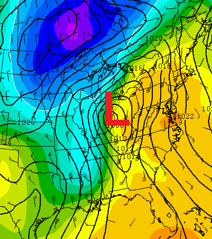
That type a track could put us in line for a round or two of severe weather late Wednesday into Wednesday night. That will also mean we are likely to see a lot of rain as a couple of systems dive in behind the main low through early weekend. Check out the numbers from the European Model…
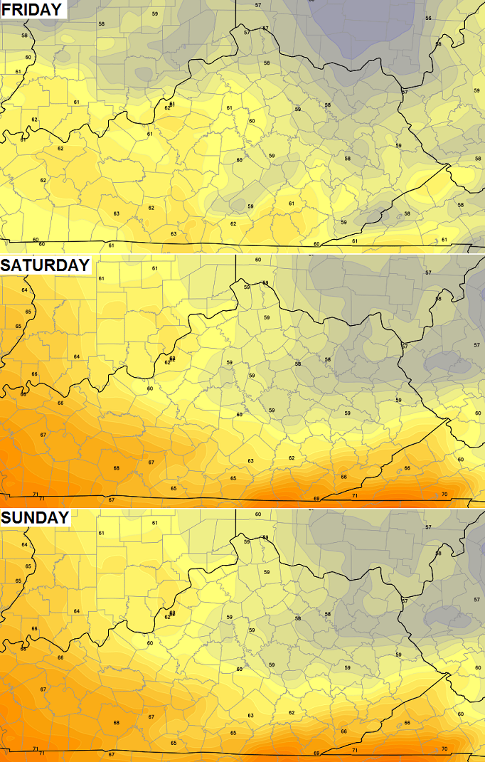
 Gusty winds and very cool air sweeps in behind this for the rest of the week into the coming weekend. Highs could struggle to get much past 60 degrees on any day that features some clouds and showers…
That’s ugly!
Enjoy the day and take care.

That’s not ugly, I see it as a blessing to get away from this early heat and I’ll enjoy everything that mother nature throws at us, and yes, even the heat. (But not nearly as much) This cool shot could be the last extended cool/borderline chilly weather until next fall. I’m going to take advantage of it.
That’s not ugly, I see it as a blessing to get away from this early heat and I’ll enjoy everything that mother nature throws at us, and yes, even the heat. (But not nearly as much) This cool shot could be the last extended cool/borderline chilly weather until next fall. I’m going to take advantage of it.
That’s not ugly, I see it as a blessing to get away from this early heat and I’ll enjoy everything that mother nature throws at us, and yes, even the heat. (But not nearly as much) This cool shot could be the last extended cool/borderline chilly weather until next fall. I’m going to take advantage of it.
I have no idea what happened with the comment, it posted 3 times.
Yard work day today, looks like messy weather for the next several days, thanks for the updates Chris!
Man, I agree with Israel. That cooler weather is welcome relief already. Plus 60s aren’t exactly cool. With this May sun 60s will be pleasantly warm. The phrase ugly is now just being thrown around for fun. It has no weight anymore, if it only means anything less warm than hot.
I think what CB is implying by (ugly) is temps struggling to get into the lower 60’s gusty winds that will make it feel alot cooler and showery weather. Not the most pleasant look or feel so ugly is suitable.
Yes. It will be a shock to the senses as feel-like temperatures of 90 degrees are replaced by the comparatively raw, wind and rain-driven upper 50’s and low 60’s. Ouch, I can almost feel it.
The humidity of today and yesterday are not the most pleasant feel either, so ugly is suitable now as well. I’m just taking my gripe with the word ugly and running with it.
CB, this blog and your weather acumen are welcome distractions on a daily basis. Thanks for all the hard and dedicated work. My issue with semantics stems from my own makeup and preference I suppose. I deal with the cooler side of things better, but no matter the weather I am out in it every day all year long, and your forecasting is right down to the hour. It really is that good.
Nice little thunderstorm just blew through east frankfort, heavy rain, lightning and brief strong winds!
Just got the yard work done in the nick of time 🙂
Yay for good timing! 🙂
Chris said today was the day for any yard work, the next few looks soggy!
While I have enjoyed apartment management doing the yardwork for me 😉 , think that enthusiasm is starting to wane. The wife and I are nearing a decision on a home, so we may be doing yard work before long. Think it will be great to actually have our own yard. Good for the dog – even when having to clean up after the dog ;). Good for any future kids.
Whoops, that’s TennMark
Looks like severe weather could be in the offing for tomorrow before the “ugly” settles in here…
Yes, most of TN, KY and OH are under a Slight Risk of severe wx for Wed. At this time, damaging winds might be the threat with the highest chances. However, an isolated twister or two is not out of the question, especially from northern Kentucky into Ohio.
+ + + + + +
If we can hold out a few more weeks, we can breathe a bit easier on the tornado threat. At least for Kentucky, past climatology shows there have never been any tornadoes stronger than F3/EF3 between the last week of May and November. Also no twisters stronger than F2/EF2 from about mid-June until Oct.
Can anybody say Blackberry Winter?!!!