Good Monday, folks. The week is off and running on a summer note as temps and humidity levels both increase. Enjoy it while it lasts… massive temperature changes are blowing in over the next few days. This will lead us into a period that borders on becoming chilly.
Thermometers today will be tricky because of the threat for thunderstorms. If we end up seeing more sun than storms, temps will surge into the low and middle 80s. Gusty winds will crank up today and could spawn a few strong storms. Hail and high winds will be the main threat from the strongest boomers. Here’s regional radar…

Tuesday will be another very windy and very warm day with the threat of scattered showers and storms increasing from west to east. The front responsible for the boomers will put the brakes on across the state as low pressure develops and moves over top of us. The end result will be a big temp spread from west to east and occasional rain and thunderstorms developing.
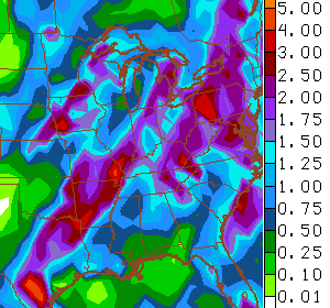
Heavy rainfall is likely from this. Check out the forecast totals through the end of the week…
Winds look to become very gusty as much cooler air blows in later Wednesday and Thursday. Some of the models suggest temps may struggle to get much past 60 degrees for highs late this week or into the weekend. With a northwesterly wind flow and a few disturbances bringing clouds and the chance for a few showers… that could help keep afternoon temps way down.
The GFS tends to overdo the cold air in situations like these and it’s would appear to be going overboard with low temps…
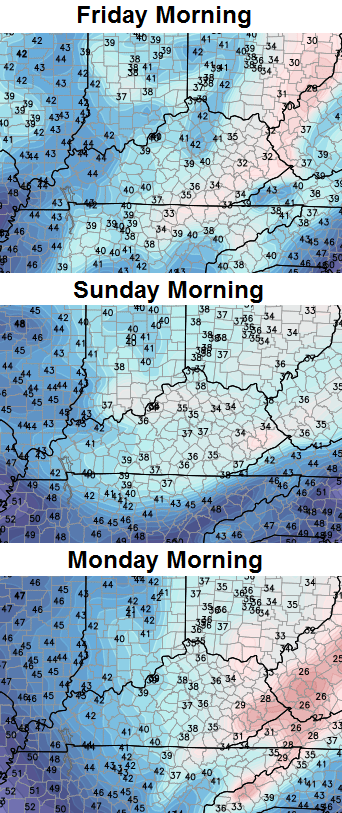 I wouldn’t be surprised to see some upper 30s show up, but that’s likely a bit much.
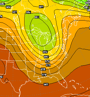
The cool pattern likely hangs around into early next week. I mentioned how the overall setup has shown amazing consistency since last fall with troughs diving into the east. The GFS forecast for the last week of May…
 The more things change… 😉
Have a great day and take care.

Enjoying humidity is very close to enjoying a tornado. The people who insist they like either are forged from tougher stuff than what I am made of. Wednesday can’t get here soon enough for me.
While I can take warm humid conditions better than cold and snow, I admit the much higher dew point temps as of late make it a bit uncomfortable even for me. Does not help that I have been sick with a cold. Thus, I actually turned on the AC even though I can normally deal with a bit higher heat and humidity without AC.
Not me………I’m an AC hog…….I think there was a couple of times I even turned it on in March……..It stays on either 70 or 71……..I see some people saying they keep theirs completely off unless it’s in the 80s and keep their thermostat at 77 or 78……..I’d be miserable ….I think it’s because in the winter, I keep the heat on 65, so i’m used to that and when the summer comes, it’s like my body wants it to be 65 in the house…but I can’t turn the ac that low
Thanks CB for keeping us informed!
Hope all mothers had a happy Mothers Day! As it is, I think everyday is Mothers Day and Fathers Day. This said, still regret that I was too sick with a cold to be with my parents or my wife’s parents 🙁 . An all day sleep seems to have done some wonders for me. However, my sleep pattern is off (not usually up at this time), and I still have to go to work early Monday morning 😉 .
– – – – – – –
NWS Paducah did a survey of the Friday storm in Evansville IN and found damaging winds of up to 120 mph. Would not be too suprising if some damage happened in Kentucky just to the south.
http://twitter.com/NWSPaducah/status/465272424020197376/photo/1
One home lost virtually all its roof which is similar to EF2 tornado damage, but again this was not a tornado but very strong winds. Lucky there were no injuries.
This may be the warmest “above normal” it gets all summer. I see the exact same pattern as last summer heading into another snowy and cold winter.
Bjenks,
Where are you getting your info that we will be cooler this summer? According to the Farmer’s Almanac, they see our summer hotter and rainier. The new Climate report also states here in the Ohio Valley, we can anticipate a continued longer growing season, more heat waves, and rain/flooding. Just curious. Many thanks!
I am enjoying the Alaska blocking pattern.
I would love dips in the jet stream all summer long.
Its sure not as comfy as last week that’s for sure
Thanks Chris for keeping the info coming. I know it gets pretty quite on here in the summer months, but I’m sure theirs a lot of people like me that checks in but don’t comment. Never the less we check in. And on those stormy days we know we can keep up with what’s going on around us.
Hope every one feels better!
Thanks Chris. I hope everyone is enjoying the warm weather. Yes, I could do with lower humidity , but I will take what we are getting over the cold. While I do love cold and snow, I like it when it comes in the winter…. Dec through Feb… 😉 Of course, our weather pattern has been a bit wacky for a while now, so what else would we expect?
I hope we don’t get too cold though, because my body is making the transition to the warm weather side. I like wearing my short sleeved shirts and sandals! Also hope the precip leaves by Friday, as my daughter is graduating from WKU with a Masters Degree, and I am hoping that the weather will at least be dry. Everyone have a wonderful Monday, and make the most of it! Thanks again Chris, for all you do! (And I agree with RickieH on the every day readers, but sometimes no comment.)
A friend of mine who lives in Denver posted pictures of her snowy backyard on Facebook.
Needless to say, I’m jealous. I’m already over this heat and humidity. Cooooommmmeeeeee ooooonnnnn October!
PARX r8 6 hoss,,,,,
#5 horse 😉