Good Sunday and Happy Mother’s Day to all the moms. Mother nature is delivering a shot of warm temps for this big day and those warm temps hang around into the beginning of the new week. After that… things take on a rather ugly look for our region and much of the country. The cool is coming back!
Highs today will range from the upper 70s to low 80s and we will have to watch for a couple of storms developing. Track away…

Current temperatures

Monday will be another very windy and very warm day as highs reach well into the 80s. If we can keep the clouds and storms away… this could be the warmest of the year , so far, for some areas.
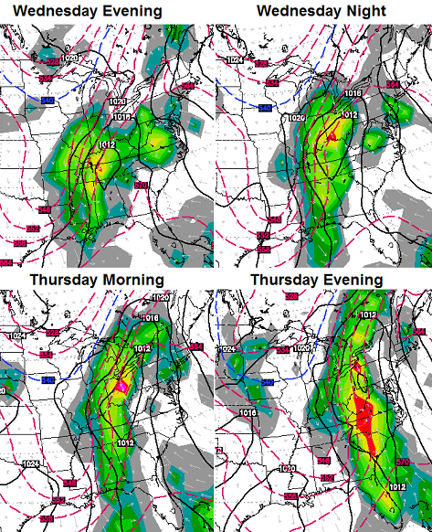
Scattered storms increase later Tuesday as a cold front nears the region from the west. Temps could spike into the 80s ahead of this. That front looks like it wants to slow down and allow another low to develop along it for Wednesday and Thursday. If that happens… it gets ugly. The European Model continues the windy, wet and cool look…
 The upper level look to the overall pattern for North America looks pretty familiar…
 Blocking across Alaska and a deep trough into the eastern part of the country… similar to what we have seen much of the past 7 months.Here’s hoping this doesn’t work out, but there’s nothing about the recent pattern to suggest something like that can’t happen.
Have a great Mother’s Day and take care.

Nothing below freezing right? That’s all I care about!
All I have seen thus far are low 40’s for morning lows… not sure what Chris is thinking? I commute by bike to work every day so I have acclimated to the nice morning temps. Temps in the 40’s will feel like the 30’s to me and my riding mate!
If we could just get these cooler spells in July and August that would be great, something tells me we will go from very cool to very hot over just a few days, time will tell I guess??
Thanks Chris. What a gorgeous Mothers Day we gave going on! Hoping the rain at least leaves by Friday. Tomorrow doesn’t sound
Like a bad day either. Think I wi find myself a nice shady spot and take a nap! Happy Mothers Day to all of my mother weather friends!
Clouds have invaded frankfort this afternoon, must be the blow off clouds from storms west of Louisville, still a warm and humid feel outside, sun looks better but this might keep the AC from running to much!
everything here in Campbell County is coming out late all the blooms.and leaves r just coming out on things.hopefully…things will get better..!!!