Good Saturday, folks. We’ve made it to the weekend and scattered showers and thunderstorms continue to rumble across the bluegrass state. This isn’t a washout weekend, but the umbrella will come in handy at times. This stormy action carries us into some big time changes as we head into next week.
The storms our there today could be a little on the strong side and put down locally heavy rain. You will have several dry ours thrown into the mix with highs in the 70s.

Mother’s Day will find temps rebounding toward 80 degrees with a mix of sun and clouds. Isolated showers and storms may come calling, but a mix of sun and clouds may rule much of the day.
Monday will find temps taking off well into the 80s on a stout southwesterly wind. This is ahead of a strong cold front that sweeps into town later Tuesday with showers and storms increasing. That unleashes some much cooler air for the middle and end of next week. Highs in the low and mid 60s are a pretty good bet and I can’t rule out some upper 30s for lows.
The European Model doesn’t look very much like May for the end of next week…
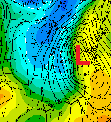 That’s a pretty wild looking setup to see this time of year and comes as a result of a big cutoff area of low pressure…
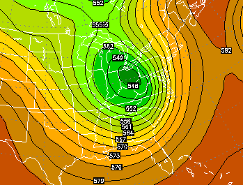
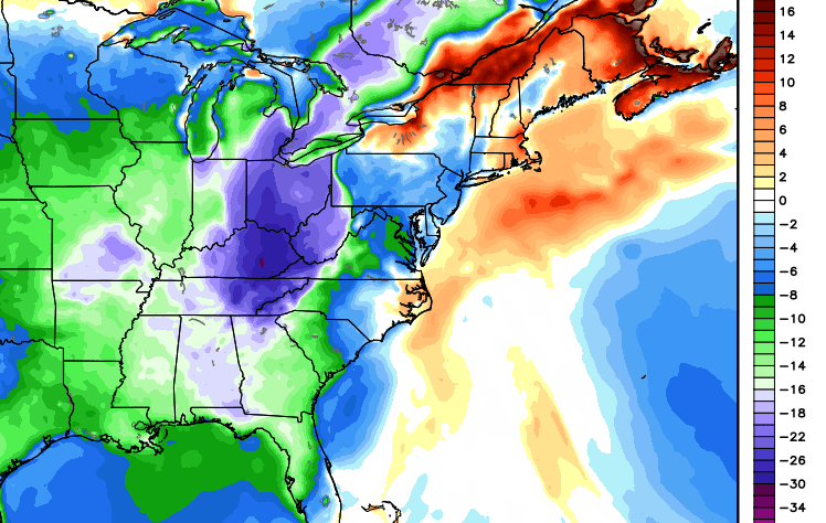
If that were to verify… temps would be even cooler than I currently think and we would have some ugly. Look how far below normal that run of the European Model has us…
 Have a great day and take care.

Right as rain…..after the summer of 2012, I am certainly never desiring another major heatwave. I visited St. Louis in late July 2012 when they had several days over 105 and that was the worst summer heat I ever felt. That’s saying a lot since I grew up on dry and dusty southern California summers.
Well we certainly can agree on that!
If it’s a cool summer, I’m gonna be bummed. After this past winter, we deserve a warm summer, not hot. Afterall, I didn’t spend 10 K on a pool and deck to look good and not get used……umm, mother nature!!!! So out of whack you are.
Mother Nature is acting completely normal this is very typical spring time weather for May. Can have high temps in the 80’s and flirt with 90 and can have temps in the 50’s and 60’s for highs.
Snow has fallen this late in the year before. *runs away and ducks for cover* Just sayin’! 😀
Not really a fan of really cool temps into mid may. I don’t want a parched summer, but I don’t want a soggy wet one either. Gonna enjoy whatever comes, but hope it’s not too cool. And hoping that the showers are scattered as I have a very important birthday party to attend this afternoon! Have a great Saturday everyone. Thanks Chris for the update.
I guess the models can’t let go of the winter looking runs, just keep the frost away, to much invested in the garden for that to happen!
Hi,
The high Rainfall Rate alarm has been activated for sensor Five in One on bridge barbourville.
The current reading for this sensor is 1.50 in/hr.
Storms building in southern Indiana look to be headed for central KY, if these hold together a noisy afternoon is likely for central KY??
SPC has a Moderate Risk of severe wx for the plains (especially parts of Iowa, Nebraska, Kansas, Oklahoma) for Sunday. This includes the threat of many tornadoes.
But there are hints that this system will become less tornadic as it drifts into our locale early next week. That said, there are still many days for the models to get a better grip on what might happen in our area.
– – – – – – – –
In the meantime, Nashville has been missing out on the regular garden variety of thunderstorms as of late; only .11 of an inch has been recorded since last night. In contrast, my wife’s family in Bowling Green reports they had a pretty good gully washer just before sunrise with lots of thunder.
When is the 2014-2015 winter forecasts\predictions coming out?
Chris usually posts his around Thanksgiving
HAHAHAHAHAHA!!