Good Thursday, everyone. The severe weather threat has been replaced by a chilly brand of air that will hang around for the next several days. We even run the risk of record lows over the next couple of morning. Can we get some patchy frost? That’s a possibility.
The colder air continues to surge in today with temps mainly in the 50s for most of the day. Gusty winds will be noted and occasional showers will be noted. Track the ugly weather…

Current temperatures

Skies will try to clear tonight and again Friday night and that will allow temps to tank. Readings in the 30s will be a strong possibility for much of the region and that would put us close to record lows. The GFS has some serious cold…
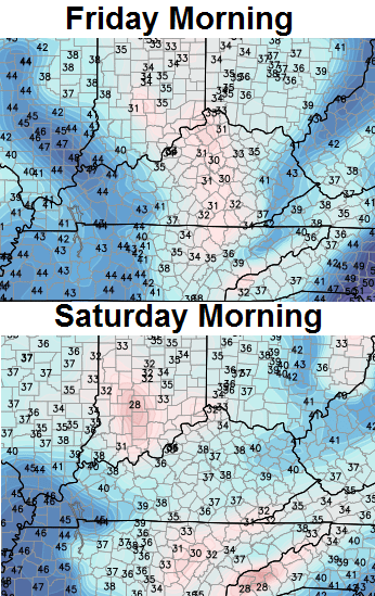
Frost will be possible if we can get winds to calm down and skies to clear. If we keep the clouds, readings will be held in check.
Afternoon highs on Friday will top out in the upper 50s to low 60s with clouds and a shower or thunderstorm bubbling up. Winds will continue to be gusty.
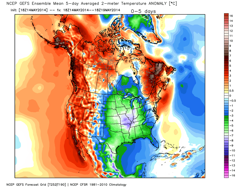
The cool temps hang around into the weekend and this puts our region well below normal for several days in a row…
 A rapid warm up is likely for the middle and end of next week…

Highs in the 80s will be likely during this time.
Have a great day and take care.

The one storm that tracked off the the west and northwest of Portsmouth yesterday was a beast!
Not liking the chilly temps, would personally prefer 90 degrees.
Wow wee what a difference a day makes.No storms at all here even with the big temp change but the cold rain has lasted throughout the night and there is still a light rain falling.Showing 50 degrees on both my thermometers.Thankful there were no bad storms.
Guess I will drag the jacket out one more time and enjoy this round of cool days.Probably be our last cool down until Fall comes.
From humid upper 80s to chances of frost, gotta love KY weather, all though it is bi- polar 🙂
Frost lol no
well my peas, spinach and kale say thank you! they love this weather!!!!
Just read a news article that a strong El Nino is expected to form this Summer, anyone with thoughts on how that could affect our weather?
Cool and wet.
U had better wave that magic wand Chris…to warmer weather…. Its kkkkkold!!!!! In Campbell county.