Good Friday, friends and neighbors. A case of ugly weather has invaded the bluegrass state and it is hanging tough to kick off the weekend. This means showers, chilly temps and gusty winds will take center stage again today. Be patient… I have a big warm up heading your way after the weekend.
High temps today will be hard pressed to get out of the 50s again. Gusty winds will make it feel even cooler than that. A disturbance is crossing the region from the northwest and will spark showers and isolated thunderstorms. With such cold air aloft… some small hail will be possible with the stronger showers.

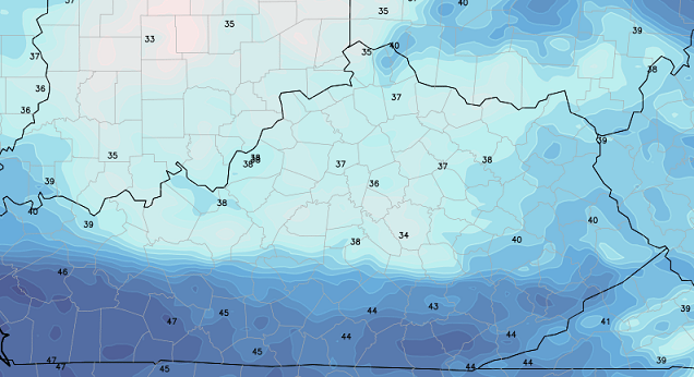
Current temperatures

Skies will try to clear tonight and that could set the stage for a few record lows to be challenged. Mid and upper 30s are a strong possibility for many spots. The Hi-Res NAM shows the areas with the best threat for 30s…
If winds go calm and skies clear… patchy frost would be possible. That’s something to watch.
The weekend weather will continue chilly with low 60s for Saturday and mid to upper 60s for Sunday. Skies will be partly sunny, but I can’t rule out a spotty shower on Saturday.
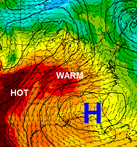
Warmer air slowly works in early next week as winds become southwesterly. The warmth really looks to kick in by the middle of the week…
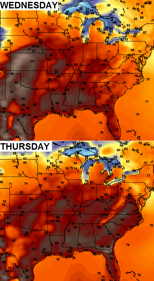
Check out the highs from the GFS…
 As I said… be patient and we will get through this round of mid May madness.
Have a great Friday and take care.

Looks like a little something for everyone is coming up for the next week or so.Its a little nippy this morning.Actually turned my propane heater on just to knock the chill off.
Thermometers are showing 38 with 88 humidity.
Not really looking forward to the hot temps coming back but I know others are and since we have to take what Mother Nature dishes out we may as well make the best of it all.Very thankful that the storms have been few this Spring.I suspect we will have plenty of hot weather during the next 3 months.
Thanks Chris. Looking like there is something to make most everybody happy coming up. Hope the rain is spotty this afternoon and evening. Traveling to Bowling a Green to celebrate my daughter getting her Masters Degree today at WKU. The biggest problem has been trying to figure out how to dress. Ah well. One more. ‘Old wives tale’ to share… Always heard that if it thunders in February, it will frost in May. So, the possibility of patchy frost doesn’t surprise me. 😉 Happy Friday everyone.
Thanks again Chris for all you do.
Gracias, Chris!
Congrats to you and your daughter, Coffeelady! Reminds me when I earned my undergraduate diploma at WKU. I was so excited, I even peeked into Diddle Arena a few days before as workers were setting up the stage. Seems like yesterday, even though it was 2008. And things for me today have changed so much even since 2008. Makes me wonder what 2018 will offer.
As fate would have it, my wife and I were in Lexington a week ago when one of my relatives graduated from UK Law School. True, I was less bummed about having a cold than discovering that the ceremony wasn’t at Rupp Arena 😉 (was at Singletary Center instead). As I’ve never been inside of Rupp, guess I will have to attend a mens UK game instead! Never-the-less, it was a memorable commencement.
– – – – – – – – –
Well, we have cracked 60 here in Nashville (now 61). Guess the cloud cover kept the temps from crashing too much last night, as the low was a chilly but not frigid 48.
Remember those times in winter when we would celebrate 50° weather and called anything above 50 warm? Now anything below 60 is “ugly”….. It’s all about perspective
exactly! I think it feels fantastic outside right now. refreshing and brisk!
Refreshing is what I was thinking too!
HRRR shows some pop up showers across the state later today – not much heat for fuel though.
Looking forward to the middle of next week!
Chris wasn’t there 30s in May 2002?
I’m not complaining.
No complaining from me either. Throw on a light jacket or sweater and it feels great out this morning.
We are going from very cool to very hot, this roller coaster needs to stop, my plants are very confused about what season this is, March or August??
For all those struggling with the adjective ugly, these posts read a bit differently if the adjective’s opposite is used. If you think pleasant every time ugly is written, the forecast changes tone while saying the exact same thing.
Omg, when I replaced the word ugly with pleasant with this post and the last few posts it’s like I’m reading something else. It totally sounds like a different tone. Good for pointing that out, just expands what I said.
Small hail in east Frankfort, looking forward to the 60s this weekend!