Good Saturday, folks. Our run of much colder than normal weather continues into the weekend, but a big warm up is on the way. That is still a few days away so we have to be a little patient with the chilly blast of air here in the middle of May.
Temps this morning could be cold enough for a touch of frost in many areas. Mid and upper 30s will be possible for those areas that have clear skies and some of the numbers could break records. While not the official recording sites, the Kentucky Mesonet has you covered with the morning lows…
Today’s Lows

Highs today will reach the upper 50s to low 60s under a mix of sun and clouds. Isolated showers will be possible during the afternoon and early evening.
Sunday looks much better with temps in the mid to upper 60s with mostly sunny skies. Temps will hit the 70s by Monday and the 80s into Tuesday and Wednesday.
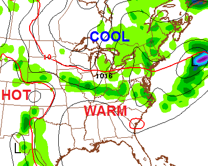
The threat for showers and thunderstorms will increase as we go into a setup that features cool to our northeast and hot weather to the southwest…
 Northwest to southeast moving rounds of showers and storms will be possible…
Have a great day and take care.

Thanks Chris. We got in on the scattered storms yesterday and some very small hail, along with everyone else. This morning it is cloudy with a temp of 44. As we were traveling the Cumberland parkway, I saw blackberries in full bloom. From my mother’s wisdom, that explains the cool weather. Looks like it’s going to be a good crop this year! ;). Have a great Saturday everyone.
We bottomed out at 38 degrees this morning in Pikeville
37 here this morning in Woodford County, right along the KY river.
according to inaccurate weather temps will be in the upper 70s to mid 80s for the foreseeable future.