Good Thursday, everyone. Rounds of showers and thunderstorms will continue to rumble across the bluegrass state today. These storms will be more widespread than what we’ve seen in recent days and this means we will need to watch for the possibility of flash flooding.
A Flash Flood Watch is out for parts of the state today…

My concern is we get a few of the storms today to dump a tremendous amount of water over small areas. The term “cloudburst” comes to mind when looking at the setup today. Keep a close eye on those water levels.
Today’s boomers will also be big time lightning producers. If you hear thunder… get inside. Isolated severe storms will be possible, too. Damaging wind gusts and hail may develop in a few areas.
Regional radar…

A weak cold front will sweep in from the north and east on Friday. That boundary will try to clean things up for the start of our weekend…
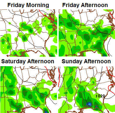
As you can see, the storm chance moves back in by Sunday and will likely hang tough into much of next week. This is part of the stormy pattern I’ve been pointing at for a while, now. This pattern is likely to give us a much wetter than normal June.
It’s also a pattern that continues the very warm and muggy air into the start of June. While I do think that settles down some later in the month, it should get toasty outside of storms next week…
 It’s more humid than hot, but 90 degrees is within reach.
Enjoy your Thursday and take care.

Love it.
Still waiting on a good down pour in east frankfort, just a trace of rain in the last 8 days, ground getting dry in spots, lots of rain has been in the forecast but most of it dodges my area??
Lately, my part of Lexington has been the same. West Lex has had about 3/4ths of an inch, Northeast has about half, but south has has had only a trace (few drops of rain also) I have heard many storms very close because of the lightning but they never come close enough, or dissapate to drop a decent downpour. The rain batch currently in Lex (11:30) has slid across north Lex, still dry here.
Lately, my part of Lexington has been the same. West Lex has had about 3/4ths of an inch, Northeast has about half, but south has has had only a trace (few drops of rain also) I have heard many storms very close because of the lightning but they never come close enough, or dissapate to drop a decent downpour. The rain batch currently in Lex (11:30) has slid across north Lex, still dry here.
It’s been hit and miss in and around Nashville TN as well. No real heavy downpours at neither my workplace nor home as of late, but enough to keep things green. Other areas near me has some minor flooding issues.
In other words, rather average wx for this time of year 😉 .
Extensive cloud cover in the northern half of KY, wonder if this holds down instability today and lessens rain chances?
Seems this is often the case. It could hold down the chances of stronger storms anyway, even there could still be some weaker rain showers.
But just before I went to bed the other night, I watched an impressive t-storm blow up out of nothing near Lexington TN (near Jackson TN) and it was several hours after sunset. As has been mentioned before, in extreme cases F4/F5 twisters have happened in the hours just before sunrise. All this a reminder to me that storms can sometimes have their own instability that is largely independent of sunshine.
Thundering Thursday is very quiet so far in central KY, the rain north of us has stalled, the rain to the south is moving at a snails pace, if frankfort area misses the rain today it could start getting pretty dry, atleast in my backyard!
I agree, today was suppose to be the highest coverage of the pop up t-storms. Some got in on it but a good majority missed out.
Glad it did not flood. But we could definitely use some rain. Sunny, very warm, and humid all afternoon. Seems we are just missing here.
Heavy rain in western frankfort just teasing us dry folks in east frankfort, oh well maybe next week will get a little rain??
Where I live, just north of the Somerset city limits, we have only had enough ran the past two weeks to wet the surface of the ground. Not brown here yet, but it IS getting dry.
I know right, all this talk about flooding and how much rain is coming the dryer it gets, what???
Not a drop all week. I’ve heard a lot of thunder and been witness to some menacing clouds but dry and dusty the ground is. Such is the nature of popup thunderstorms.