Good Tuesday to one and all. We have rounds of showers and thunderstorms working across the state over the next few days. This setup will lead to the increasing potential for strong and severe thunderstorms. The stuff coming in later Wednesday has the look of a damaging wind maker.
Scattered storms will blow across the state today and some of these could be strong. Any boomer will also contain a ton of lightning and heavy rainfall. Regional radar has you covered…

Wednesday will find a cold front rolling in from the northwest. This boundary will encounter very warm and unstable air across the Ohio Valley. Clusters of severe storms are likely to form across the plains later today and roll toward the region through late Tomorrow. Check out how the European Model sees the storms…
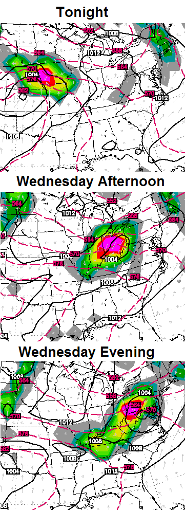 That continues to have the look of a damaging wind producer across our region and is something for us to keep a very close eye on.
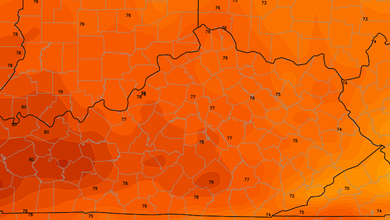
Cooler and drier air moves in behind this system for Thursday into Friday. Check out the highs on Thursday…
Another powerful cold front will work our direction by Sunday and may ignite another round of severe thunderstorms…
 Another shot of cooler air swings in behind that front for early next week.
Have a great day and take care.

The Storm Prediction Center is uncertain at this time but they are considering an upgrade to a Moderate Risk for severe weather for some areas for tomorrow.
A PORTION OF THE OH VALLEY MAY NEED TO BE
INCLUDED IN A MODERATE RISK IN LATER OUTLOOKS.
Thanks Chris. Got up this morning to cloudy skies but warm temps.
I don’t care for the mention of severe weather, but we could use a little rain in my backyard. It is getting dry. We had a small shower this morning and yesterday morning but they barely got the ground wet. I love to hear a good thunderstorm rumble through, but I would rather have it rumble through without having it be a damaging wind producer. Oh well, guess you can’t have everything you want, huh? 😉
Have a great Tuesday, everyone and thanks again Chris, for all you do.
I am with you on needing rain. The northern part of the county here had some heavy rains a few times recently. At my place it was sunny with the distant thunder and muggy.
Liking the temperature look for Thursday-Friday. If my shoulder quits felling like it was ripped out of the socket I may do some brush clearing.
Have to say I have enjoyed the weather so far this spring overall. Have not needed the AC at all. Hopefully the summer is just as nice.
I wish I could say the same. I’ve kept my AC on 70 and it came on quite a bit when we had the muggy mid 80s .My AC is on right now, but it hasn’t kicked on very often the past couple of days……I’m so spoiled by AC it’s ridiculous….then again, in the winter, my heat stays on 65. I’d much rather be cold than hot.
Hey Chris – there will be many graduation ceremonies Friday night. Any predictions for a school that normally celebrates out on the football field?
Not Chris but from what I’ve seen the weather should be perfect for most if not all folks.
I’ll take a little severe weather if my yard can get a decent rain out it, two weeks tommorrow since anything more than sprinkles!
Storms firing in southern Indiana AGAIN, probably will fade or dodge the frankfort area if the latest pattern continues!
Your right!! They dies out big time
What is the weather looking like for tomorrow? We have outdoor activities (all day) planned for our school children.
I echo the comments of Coffeelady and others. Yards are starting to get brown in my subdivision just north of the Sometset city limits.
^^^^ Somerset^^^
The more talk about the heavy rains that are coming the more I’m hearing about how dry its getting in most areas, have not heard Chris address this much yet?
The models have been way too wet lately. That’s the problem. They show a lot of rain, we only get a little, and some areas get none at all. Who knows if the next few systems are being overblown, as well. Here in East Tennessee, we are getting very dry. Knoxville is about 5 inches below normal for the year now, and it just keeps getting drier.