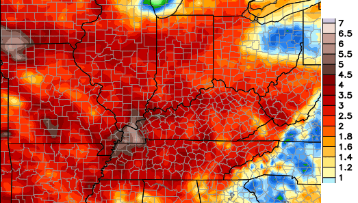
Good Monday, everyone. The stormy pattern we’ve been highlighting continues to ramp up and will kick into high gear later this week. That will lead to clusters of storms rolling across the state and these can put down a lot of water before all is said and done. A few of the boomers may go severe on us.
I really don’t have a lot of changes to the thought’s I’ve had out for a while now. Scattered storms will fire up today and these will contain very heavy rain and a ton of lighting. Track away…

Outside of the storms, temps will hit the low to mid 80s with a serious case of the muggies. The muggy factor will kick it up a notch for the middle and end of the week as the air goes tropical on us. The showers and storms will increase and we will likely deal with some severe storms and torrential rains.
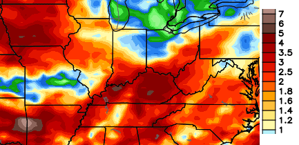
The European Model continues to put down a lot of rain over the next week…
The Canadian Model agrees…
 The pattern has been itching to go back into a cooler period and that itch looks to be scratched as we head into next week. Check out the big dip in the jet stream being forecast by most of the models…
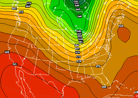 Me thinks that could be a familiar jet stream configuration this summer. I will talk about that on WKYT-TV tonight at 6.
Have a great day and take care.

Not liking this forecast one little bit.Going to focus on the possibly cooler air coming next week.Hope we aren’t going to have 3 months of heat and high humidity.That “itching to go back into a cooler period” can’t get here soon enough for me.Oh well we have take what comes so may as well make the best of it.[:^}
My better half (wife) is the same as you.
In contrast, I can take the heat and humidity somewhat better than the cold.
This leads, among other things, to some compromises regarding the thermostat 😉 .
We can’t change the weather so complaining is fruitless. I am happy to be alive, regardless of cold, warm, wet or dry.
So my area finally got a decent downpour yesterday, and it happened to come at the exact time I needed to run a very quick errand on the other side of Lexington. I did not get to enjoy it, I only enjoyed the wet pavement/gras-s and the nice smell of petrichor. Maybe today there will be a chance I can actually enjoy a decent downpour?
Still no measurable rain in my yard since may 21st, this area of frankfort every summer is the dry spot of the state, just strange how these storms miss us so consistently ??
I’ve had less than a tenth of an inch of rain just down river from you on the Anderson/Woodford line in the same time frame. I’m looking at is as a break from mowing.
Im just trying to figure out why the weather pattern in my hood locks in to this dry zone every year?
You can watch the radar everyday and see the storms fade or go around south eastern Franklin Co!
I haven’t had a drop in over 2 weeks now and it’s getting pretty dry out there. My Mom lives about 3 miles away and she has had over 2 inches of rain in the same time frame. I’m ever hopeful of a downpour but hit and miss is the nature of summer thunderstorms.
The hits keep on coming for some folks daily, while others dry up??
Southern Indiana getting hammered again, I can already see the drying trend coming for central KY tonight!
Looking like Indiana is in the bullseye for the rains again today!
At this time, the Storm Prediction Center has a Slight Risk of severe thunder storms this Wed which includes virtually all of Kentucky and a sliver of northeast Tennessee. Strong damaging winds could be the threat with the highest risk.
Areas like Nebraska have a somewhat elevated tornado threat Tuesday (SPC already has a Moderate Risk of severe wx Tue for Nebraska and other adjacent states), but by the time that system gets to our area, the twister threat will be relatively low.
This year KY’s twister season looking like a no show, which is a good thing, but it only takes one rare event to change things quickly!
We had severe storms that knocked out the electricity for hours on June 4, 1993. Lots of trees down and damage in several counties. It looks like we way have a repeat this year. However, I want to have beautiful weather for my birthday.