Good Sunday to one and all. More in the way of showers and thunderstorms will blossom across the region today. These will be working with a tropical atmosphere to produce some very heavy rainfall and a ton of lightning. Storms aren’t the only thing I’m tracking. I’m watching a big cool down and something brewing off the southeastern coastline.
Today’s showers and storms will be more common during the afternoon and evening hours. These can easily drop a quick inch or two of water on some spots. The lightning will be prolific and a few storms may be on the strong side.
Track away…

Rainfall


Showers and storms will fire up again on Monday as temps try to flirt with 90 in a few spots. I suspect storms will have something to say about that.
A cold front moves in late Tuesday into Wednesday and may deliver a line of strong or severe storms. That’s something for us to keep a very close eye on. Something else to watch our for is developing off the southeast coast. This is likely to become Arthur and may drift around for the next few days.
The models take this toward Florida then turn it back up the coast…
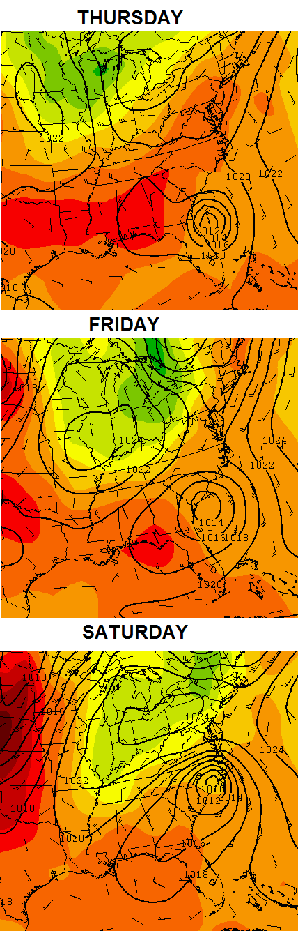
That is very interesting to see and it has an outside chance of impacting the weather around here by late in the week into next weekend. As of now… it looks dry and much cooler for the 4th of July. Check out how much below normal the European is showing…
 I can handle that!
Make it a great Sunday and take care.

Thanks Chris. Looking at the radar this morning looks like a big wad of storms in northwest Tennessee. If it’s moving northeast, we will likely get it pretty good. I can handle a bit of a cool down for a couple of days. But we will take each day as it comes and enjoy them. Have a great Sunday everyone!
Wow, radar looks impressive down in TN atm (10 AM).
Poor folks down there must be having a terrible time retrieving roadkill for Sunday brunch in such weather.
That was a unnecessary comment.
It was funny though.
Not if I would have said it. 😉
the question will be will the rain make it to Louisville.
I am having a rain shortage.
I am watching the radar trend to the west.
At this point, who knows. It seems like when we have good chances for rain, it’s overcast on the day the chance is highest, which I’m guessing is the cause of less activity……
yeal, I am already seeing the rain beginning to fade out west.
it seems points from Evansville to the west cannot complain about rain fall this summer.
I wish we were in Minneapolis! This powerful cold front that’s forecasted will bring highs in the 60s and lower 70s a few days in early JULY! Wow, that would feel so good about now. But for us, MAYBE upper 70s to lower 80s with lower humidity. (That’s still a relief though)
It’s feast or famine in the rain department these days, your area is either very wet or very dry, just wish the showers would cover more areas.
Oh well, nothing we can do but hope one pops on top of ya!
yesterday and today = feast for my backyard already more to come it appears
South east looks to be the sweet spot today, just a couple spotty weak showers in Ncentral KY area!
Another underperforming day of rain. At least it’s cloudy and the Sun isn’t beating down on us.
Parts of Memphis Tennessee has had as much as 5to10 inches of rain in the past 24 hrs. All kinds of localized flooding occurring there.
I don’t want that much but an inch or two would be nice. I’m less than an inch for the month of June.
1.28 total today
Pretty dry here in our part of Carter Co. Some rain yesterday afternoon, but not enough. Just watched another band of rain go through with only a drop or two falling here….it just skipped over. Oh well, maybe later.