Good Thursday, everyone. A massive weather change is about to blow into the bluegrass state over the next few days. This includes everything from gusty thunderstorms to the possibility of the first frost of the season and crazy cold wind chill readings. Buckle up for the ride!
You know it’s a busy time when I bust out the headlines…
– Temps today will be obnoxiously warm for this time of year. Low and middle 80s will be a good bet with a late day shower or thunderstorm possible in the west.
– Showers and thunderstorms work eastward with the cold front on Friday…
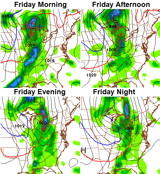
– Heavy rainfall and gusty winds will be likely throughout the day. Wind gusts may approach 40mph at times as the front approaches from the west.
– Temps will stay in the 70s ahead of the boundary and then drop through the 50s during the evening.
– Lows by Saturday morning will hit the upper 30s in many areas. Lows by Sunday morning will be even colder…
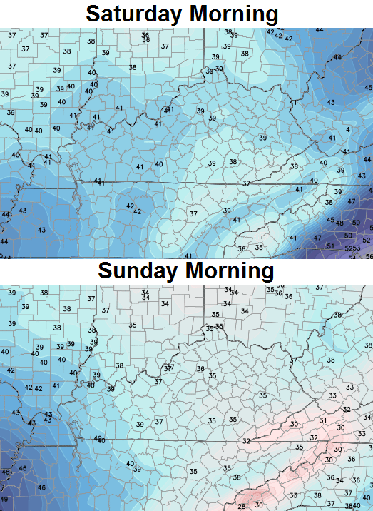 – Frost is a real possibility by Sunday morning if winds can stay calm.
– In between the cold weekend lows will be a Saturday straight out of November. Highs will only be in the low 50s, but gusty winds will make it feel much colder than that. It’s the first weekend of October and I’m tracking absurd wind chill numbers…

– There is also a small shower chance on Saturday.
– Another shot of chilly showers will move in on Monday and Tuesday.
– The overall pattern looks to be loading up for even colder shots of air to show up for the middle and end of October. Maybe some early season fun and games again? Hmm
I leave you with some tracking tools for the day…
Today’s risk area

Current watches

Current Temperatures


Have a great day and take care.

Wow.What a change and really quick.80s today to 50s a day or so later.
Weather is always exciting.I have mixed feelings about such big changes.I love the cool and brisk weather but at the same time I feel like a long,bleak winter is upon us.
I suppose we will have a few warm days before it locks in to stay but lately its starting to feel like the warm days may be over till next year.
Guess its time to make sure the heating is all set to go.
Thanks Chris for all the details. Looking like it may be a long.busy winter for you.
Crystal, aa of late we have had cool night and pretty warm days. Mid to late week of next week upper 70’s maybe a 80 degree day. To me this typical fall weather, late summer trying to hold on as fall makes its appearance felt more and more.
I am a winter lover and love the snow but it seems Winter was just over and here we go again. I am not ready yet. I suppose I better get ready bc its coming whether I want it to or not. Thanks Chris for all you do!!!
OCTOBER SNOW coming!!!!!!!!!!!!!!!!!!!1
I think you are right Rolo
I don’t think will see snow until November
And then in two days you get “move aling folks nothing to see here”.
Or maybe December like in 2012?
I’m in Virginia, and I’m excited! I went on Farmer’s Almanac’s blog yesterday to find that the Persimmon Lady opened 20 persimmons and ALL of them were SPOONS!!!!!!!!!!!!! About 98% of folks in this country found SPOONS!!!! Get ready to get ready folks, this fall/winter season might be a doozy!
Thanks Chris. Hopefully it won’t get that cool in the south, as we are leaving for Daytona today. I want some good warm weather down that way. Sounds like great football weather though. And I guess we can’t hang on to summer all the time….ah well, autumn is nice, too.
Have a great Friday Eve everyone!
5 out of the last 6 months have come in above average. I bring this up because it seems the eastern half of the U.S. has been one of the cool spots, yet it is still hovering just above average. Worth noting, I thought.
I am curious as to whether there is a particular month/season that you see the most change in the pattern. You have been emphasizing that the pattern has remained the same since late last fall. It seems that September/October is the time that patterns are most subject to bigger changes, which they did last year. The farmers almanac used to wait until then to issue their long-term forecasts but now want them on the newstands a little earlier. Not many meteorologists are willing to dabble much in the long-term forecasts so I would be interested in your insight and I’m sure you’ll be discussing long-term/winter implications in the coming days anyway.
5 of the past 6 months where? Not in our region. This was a colder than normal spring and summer for the Ohio Valley and Kentucky.
Louisville was above normal for September, August, June and May. Other than July, it’s been a pretty warm run since May.
Still was above normal where I live for four of last five months. It wasn’t a hot summer like we often have here but was still above normal for those months, just that July skewed the numbers for the five month rolling average.
The second graph shows below normal when you include January. February and March. My comment was 5of the last 6 months came in above average for Lexington. July was the only month below average.
This was merely an observation leading into my question, which I was genuinely interested in your expertise on but you did not answer. I enjoy your blog and appreciate the work you have put into it but now we seem to be arguing over undisputed facts.
This shows normal/average for June July and August combined. You know well that most areas in central ky were above normal June and August. July was far enough below to balance it out.
Yeah, jdthom, I think you are mistaken and you’re looking at the past 6 months for Lexington. If you look at the past 12 months for Lexington, 7 out of 10 have been warmer than normal but if you look at Frankfort’s data, only 4 of the past 12 months have been warmer than normal. Lexington’s official climate data has been corrupted since last spring of 2013 because of the faulty temp sensor.
You’re right, I was looking at Lexington. But April, May and June were above normal for Bowling Green, Frankfort, Louisville and Lexington. July was below normal for all sites. August was above for Bowling Green, Lexington and Louisville Standiford and September was above for Lexington and Louisville Standiford.
As far as there having been a faulty temp sensor for over a year, that seems like something that would be a serious problem for the airport given they are making serious safety decisions based on the temp. I don’t know what you base that on but if you’re right then that’s a serious public safety concern and should be reported immediately.
As the SPC map above on the KWC blog shows, western parts of Kentucky and Tennessee under a slight risk of severe wx at the day progresses. A few warnings already up west of us. At least the tornado threat, while not zero, is relatively low. Strong damaging winds look to be the main player.
Ah, I am lovin’ today’s weather! 86 degrees in Lexington!!! Actually the weather the past few weeks have been right up my alley.
I just wish I could up and move where it was like this the next 6 months then come back to Kentucky. Oh well. Time to hibernate unless things hit the fan.
But back in the upper 60s to mid 70s here in SE Ky. by Tuesday and Wednesday….It aint winter yet!
Nope… it’s going to rain those days.
Nope, its going to warm up…..Sorry Charlie.
.MONDAY…PARTLY CLOUDY WITH A 40 PERCENT CHANCE OF SHOWERS.
HIGHS IN THE UPPER 60S.
.MONDAY NIGHT…MOSTLY CLOUDY WITH A 50 PERCENT CHANCE OF
SHOWERS. LOWS IN THE LOWER 50S.
.TUESDAY…PARTLY CLOUDY WITH A 40 PERCENT CHANCE OF SHOWERS.
HIGHS IN THE UPPER 60S.
.TUESDAY NIGHT THROUGH THURSDAY…PARTLY CLOUDY. LOWS AROUND 50.
HIGHS IN THE MID 70S.
NWS Forecast…not even for SE Ky…..this is for DANVILLE. Let’s see what happens.
Why do I care what the NWS says? Maybe that’s your issue you have with me? Because I don’t follow what they say?
You realize there is no human input into those forecasts, right? It’s basically straight from whatever the last run of the GFS said.
My name is Chris.
There are days I just want to stop putting so much free time and effort into this blog. Today is one of them.
Hey Chris,
Just take a breath…everything is fine. Loving the super warm day today! It helps me appreciate the temperature swing that is coming. Hoping that there aren’t too many times left to mow the yard. Have a great day!
You are awesome CB! Just ignore these deniers, they just want to get a laugh from you. When you come to think of it, the more known and awesome you are, the more haters you will have. Unfortunately that is how it is.
Aren’t comments on a blog for fostering debate and conversation? A little give and take? No one is throwing f bombs around, just friendly debate.
Isreal – are you still moving?
Times have been a little hard for me lately. I am not so sure and undecided right now.
Chris please there is so many people who depend on you these haters on here just over look them this blog is special you know your stuff that’s all that matters please we all need you and this blog
Chris. You will never EVER make everyone happy…….Just ignore the negativity……..Even when I’m negative..I try not to be though 🙂
Tornado Watch now in effect for western parts of both Kentucky and Tennessee. Still, strong damaging straight-lines winds are the threat with the highest risk.
Northern Kentucky was far from above normal the entire spring and summer. There was only 1 high temperature above 90 recorded at the Boone County Mesonet for the entire summer, and it was barely above 90. LOL http://www.kymesonet.org/historical_data.php
I don’t follow the exact temps so I couldn’t know technically if it was warmer or cooler.But basing on the number of days I ran the AC and cost of my electricity use and days I worked in the yard a bit I would have to say it was quiet a bit cooler.Don’t recall any 100 degree temp at all and hardly any 90 or above.Maybe its just where I happen to live but my summer has been cooler than average.
As for the detailed forecasts posted here I greatly appreciate them.Rarely are they off much at all and no where else do we get such detail for our area.It just a generic one size fits all elsewhere.
When you live in a place that you need to prepare well in advance for bad weather those details are what you want to know.
Seems odd to be so warm today compared to Friday .The radar is really firing up to our north and west as the night goes on.Starting to get a bit concerned looking at the maps.
Nice blast of late fall weather coming in for the weekend, but everything I’ve seen indicates that we moderate into the upper 70’s to near 80 by next weekend. Bummer, I will be in Clemson, SC next saturday for the UofL-Clemson game, and temps could be mid 80’s.