Good Friday to one and all. The big change we’ve been talking about for well over a week has finally arrived. A powerful cold front is crossing Kentucky today and will bring wind, rain, thunderstorms and a blast of November temps. As usual, I have you all set to do some tracking.
Showers and storms will work across the state in waves today. This means we will get a some dry times between the action… especially in the afternoon. Locally heavy downpours and gusty winds will accompany the storms. Winds will be gusty outside of the storms, too. Gusts of 35-40mph will be possible.
Lingering showers will zip through here this evening as temps take a big tumble through the 50s. Bundle up and grab the poncho for those high school football games.
Saturday continues to look super chilly with upper 30s and low 40s to start and 50s for highs. Some clouds will filter back in and I can’t rule out a shower. Winds will continue to be rather gusty and that will make it feel even colder.
Patchy frost is possible Sunday morning as lows drop deep into the 30s. The only thing keeping this from being a widespread frost will be the winds.
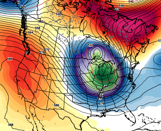
This deep trough settling in for the weekend is VERY impressive…
That same trough leaves a piece behind into the first half of next week…
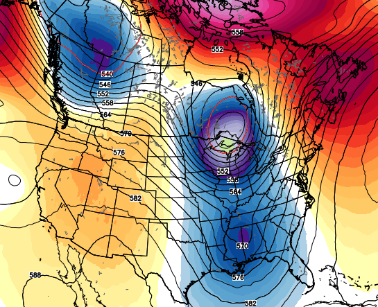
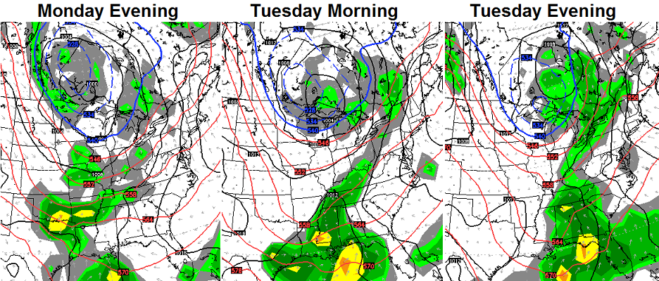
That means an increase in rain for Monday and Tuesday as low pressure develops just to our south…
 That’s very close to becoming a cutoff low that would linger deeper into next week. We’ll have to keep a close eye on that possibility.
First things first, though, and that’s tracking today’s weather…
Current Temperatures


Sustained Winds

Current Temperatures
Have a great day and take care.

Overnight lows in Madison of 68 to 72. Normal low 52.
What’s the record low max? I’d think around 20 degrees over the norm would at least be top 10 for this date.
Flew in from the UK yesterday and the lakes and small streams in the Canadian Maritimes were iced over as was seeing a large swath of coastal sea ice. Not much snow-rare patches-BUT- this seems to be pretty early for that in my visual experience. Does that bode well, can we consider this a good omen for Winter 2014-15? Hope so!!!
My tomatoes are diggin this rain!
Just taking a moment to whine… why did this weather have to hit on the weekend? The whole family has big plans for this weekend. We’ve had such beautiful weather and I know it can’t last, I just wanted this good weather to last three more days.
A few brief showers with gusty winds.Hasn’t last long each time but its gotten cooler.Good little breeze blowing too.Thermometers are showing 58.
On the way from OBX saw beautiful foliage in the higher areas and a couple of brief heavy showers around Charleston, WVA made driving very dangerous. Looking forward to trees turning here soon to peak colors. Glad to be home and get great weather info.