Good Saturday, everyone. Wow… it’s cold out there. Those are words you are likely to hear a lot of over the next couple of days as temps tank. We have the potential for frosty cold readings close to the freezing mark early Sunday. The cold is king right now, but the pattern is taking on that super duper active look over the next few weeks.
Let’s start with the cold. Temps today will only reach the low and mid 50s after starting the day in the upper 30s and low 40s. Gusty winds will make it feel much even colder. Some clouds will filter back in this afternoon and early evening and a shower or two may try to develop…
Current Temperatures


Skies will clear tonight as winds diminish some. That combo will allow temps to drop into the low and middle 30s. A few of the colder spots have a shot at dropping below freezing. The Hi-Resolution NAM is picking up on this…

Take care of the tender plants and vegetation!
Sunday afternoon temps continue to look cool with upper 50s to low 60s with some clouds increasing. I can see a shower developing in the evening hours. A better chance of showers will be with us Monday with heavier rains by Tuesday…
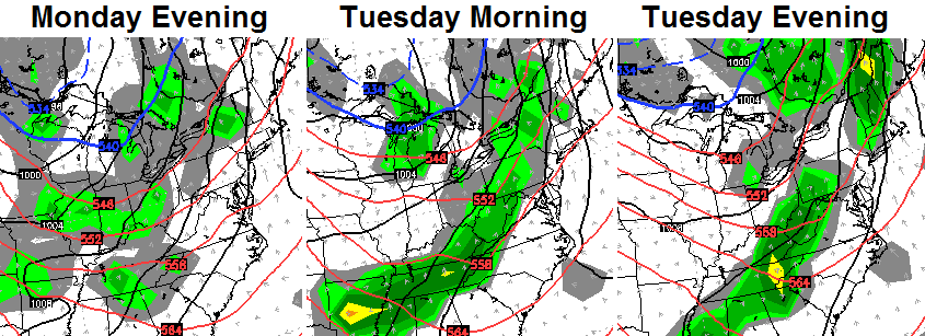 That will keep temps in the 60s for highs with the potential for even cooler numbers for areas socked in with rain on Tuesday.
This is a very active pattern that will throw another system at us by the end of the week into the following weekend. The models bring a cold front with showers in here late Wednesday and Thursday and then stall it out by Friday. That allows waves of low pressure to ride across the region from the southwest. The European Model…
 The new GFS is a littler quicker with these systems and indicates very chilly air by the weekend. Heavy rain numbers are very possible during this time. The European Model follows all that up with another potent system…
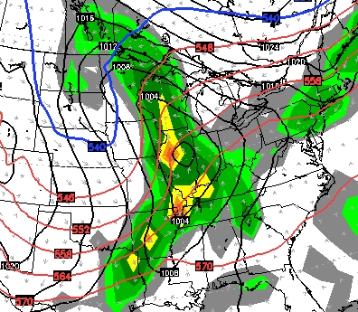
That’s also a nice shot of chill coming in behind that.
Why is this pattern becoming so active? Blocking is showing up and that leads to a very amplified pattern across the country…
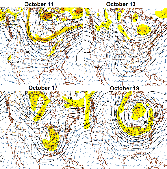
By the way, the amount of blocking showing up is pretty tremendous for this time of year. That is usually a good sign for winter weather lovers. I will touch more on that in the coming days.
Have a good Saturday and take care.

I found something really cool (at least I thought it was cool) ..It’s a satellite view of the entire superstorm ’93 and then at the end, it zooms into our region and you can see the snow on the ground. I wasn’t living here at the time. I was in Western NC. I guess the topography makes some places look like they got more snow than others, but you can clearly see where if you were west of Lexington, you hardly got anything… Imagine what this blog would have been like back then…
http://www.youtube.com/watch?v=tb5E1qmCdH0
I’d imagine it would have been something along the lines of…
“-hey, mom/dad did you know that there are only around 100 or so pages on this “world wide web” and on this one you can talk about our weather here in Kentucky?”.
“-oh really? Hmm. Say kid, show us real quick how to use that thing to type stuff and see what’s being said”
“- sure thing, here’s how you do it…”
“- and that’s all there is to it, huh? Great!”
*kid is then immediately pushed away from his insanely expensive desktop (which better have NeXT OS or adapted Lynx for UNIX since it’s winter 1993) and glacially slow modem by the nearby adults and has it subsequently taken out of their room and put in the den or living room from then on*
Wow. Looks like places as far south as even Alabama got a good thumping out of that one. Being on the far western edge of that is pure luck, though—all about location, location, location. Look at how well-defined the cutoff is–it could’ve been anywhere in the state, the difference between feast and famine in the snow department.
Love it. Great weather. Monster college football Saturday today!!!
NWS not biting. Still going with mid to upper 70’s for eastern Kentucky for the end of next week into the weekend. We will see.
Nothing… and I mean NOTHING remotely suggests that for next weekend.
Your own station has a high of 74 for Friday.
It is always at least 2 or 3 degrees colder where I am than is forecast on most the sites.
It has been down right chilly here today.I have checked both my thermometers throughout the day and one reached 48 and the other on the sunny side of the house made it to 50.With the light breeze blowing it felt even colder.
I don’t know why there is so much variance from site to site but TWC has us at 75 on Wed and Accuweather has us at 76.WKYT has 63 for the high Wed.
This is why I hang with the forecast on this blog.It hits the closest for my area every time.Very confusing for me when there is that much difference.
Not the 7 day forecast I just saw online. It has low 60s and rain.
Chris is right about the temps, IMO. Not going to get that warm with that much moisture moving in.
3-mile hike was invigorating. Chili still simmering in the crockpot. Hopefully better football games than Tex AM and Miss St. Thinking Cats have a clawing chance against Spurrier’s Inferiors and this coming from a Cardinal alumnus. Frost Advisories out…about time. Even I saw this from several days out. C’mon NWS.
Diehard UofL fan myself but I will pull for Kentucky when not playing UofL. If Denny Crum and Joe B Hall can be great friends and have a sports show together Monday-Friday then there is no reason why I cant pull for UK when not playing UofL. ☺
UK better start to figure this game out real fast or its going to get really ugly really quick.
My personal prediction for this winter—-cold, but not as cold as last winter. More frequent, larger snows, but not as many days with snow on the ground. I can see at least one 6″ snow, with the possibility of one exceeding 8″. Other snows, maybe 6 or 7, will be less than 2″.
I am honing in on the week of January 11-18th for the biggest snow. No, I’m not giving away my secrets. 😛
You’re a meteorologist?