Good Monday and welcome to a busy week of weather. Rounds of showers and thunderstorms will work across the state for much of the week. These waves of rain will likely dump a lot of water on our region as temps stay on the cooler side of normal.
The first in a series of systems will impact the region today with an increase in showers and storms. This is a pretty potent system that can produce strong or severe thunderstorms during the afternoon and evening. Damaging winds and large hail are the main players with the greatest focus on the southern half of the area. I will have your tracking tools in a bit.
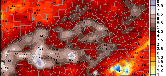
Another system swings in later tonight and Tuesday with heavy rain a good likelihood. Rainfall totals through Wednesday morning could be 1″- 2″ in some areas. Some of the recent NAM rainfall forecasts have been showing a whole lot more. Here’s one of them…

A few leftover showers will be around early Wednesday with a bit of a cooler and drier wind setting up. That dry wind won’t last long as another wet weather maker works in on Thursday. This looks to carry us into the coming weekend with heavy rainfall looking more and more possible. This could be a prolonged period of heavy rain that can cause some high water problems if it materializes. The next week’s worth of rain from the European Model is eye opening…
To make matters worse… that’s a chilly rain that will likely fall this weekend. We may see another decent storm system rolling in sometime next week. With a recurving typhoon in the Pacific, watch for the models to latch on to a deeper trough than what they have been showing.
On a related note… by the tone of some of the comments over the past few days, I get that most other weather folks were telling you sun and warm temps were coming back this week into the weekend. I do what I do without worrying if what I say matches other forecasts. If it did… I would start to worry. 🙂
Let’s get to tracking…


Today’s risk area

Current watches

Possible watch areas 


I have a day off from my TV gig and will update things as needed.
Have a great day and take care.

Sounds like it is going to be a cool and wet week.Yep TWC still has us listed for 77 on Thursday.I started basing most plans on what is here on the blog last year.We are never the temps that are forecast on the major sites.
They had our low for yesterday at 36 but it was 32 on my thermometer.
Sure hoping we have no bad storms during this rainy period that is coming.
No rain here so far tonight but seems like a lot of showers are starting to pop up now.So they will likely get to us later.
Enjoy your day off and thanks again for the detailed forecasts.
Looks like all of Kentucky is under a Slight Risk for Severe thunderstorms, be glad when the SPC updates there new thunderstorm outlooks this month, 5 categories – Marginal, Slight, Enhanced, Moderate and High. Be lot easier to understand!
Hey, it’s fall break in Estill County so I figured the weather would be bad this week! Oh, well! It’s not your fault, Chris! Thanks for telling it like it is! That’s why you have all the followers like you do. You give us the weather report like it is. Thanks!
Chris you are the only weather man I listen too!! I live in eastern ky and they NEVER get it right! Please keep doing what you do. I would like more info on the upcoming winter weather when you can. Thanks.
Chris, you are the best! I live in Pike County and I check your blog every day! I don’t even bother with watching local weather because you are always spot on! Thanks for all you do!
Hopefully, early Wednesday morning skies will clear enough to view the upcoming total lunar eclipse. Should be a good show.
From SPC…low tornado threat exists for south-central KY, including Bowling Green
Wow wee it was coming down in buckets for a few minutes.A bit of thunder but no problems from the heavy shower that just went over.No hail so far.Showing 50 on the thermometers right now and some wind.
A big clap of thunder woke me up this morning in greenup ky…we had some heavy rain for a bit…it’s very damp and cool
Here right now…Chris, thanks for all you do! I check this site every morning when I get up and there is no other place id rather get my weather forecast! You are definately more trustworthy than those other major sites! God Bless!
I guess this is what I was getting at the other day (not trying to start an argument over recorded weather data over the past 6 months). What months (or seasons for that matter) are most known for changes in overall weather patterns? You talked a lot over the summer about being in the same pattern since late last fall. Then September we got pretty dry and now we may be getting pretty wet. When do these things typically settle in? It seems that usually the September/October battle is when the pattern for the next 9-10 months gets decided. Just hoping for some big picture discussion other than just a winter forecast.
Anyone know about what time the storms are suppose to start?
Memo to the SPC: with 3 severe thunderstorm warnings currently issued in the NWS Louisville CWA, isn’t it time to issue a Severe Thunderstorm Watch?
The SPC did consider a Watch, knew the factors that would necessitate an issuance of a Watch, watched storms develop where a Watch box would have been issued, and are no doubt continuing to watch all these warnings being issued where a Watch box should have been issued.
Now, strong storms moving my way….wait a second…oh, another warning right across the river from Louisville, where there is no Watch box.
If I’m not mistaken Mike you live in Valley Station so by the way it looks the line looks to split north and south of you. Typical SW Jefferson County weather. lol However I fully agree with you SPC did drop the ball.
Ok by me if storms miss me. I don’t want the hail.
I hear that. No worries though two more shots of storms tomorrow and Friday.
SPC now has two Mesoscale Discussions saying that watches are unlikely for Kentucky and Tennessee, isolated severe storms not withstanding.
If the SPC is correct, then the local NWS offices (especially Louisville & Jackson) are wrong for issuing all these warnings. Storms probably not strong enough to cause real damage. At least the one that blew through where I live about 2 1/2 hours ago wasn’t (looked pretty though).
I am a bit surprised no watches were issued earlier in the day when SPC had a 40% chance of a watch being issued. Especially considering all the hail reports that later came in, with many hailstones being at or exceeding one inch (one of three criteria for severe wx, the other two being strong winds of 50 knots or more, and/or a tornado>/i>).
That said, watches, while very useful, are not needed to issue warnings. Watches may not be issued if the severe threat will be too isolated.
Chris, the reason I keep coming back to this site, day after day, year after year, is because I’ve found you to be most accurate about the weather, plus you explain it to weather weinies like me who can’t read the maps. Not only that, but you update often if severe storms or SNOW is around. I don’t usually pay much attention to what the others say, I just keep checking this site. I don’t comment often, but I read them. Thanks for the effort you put into keeping us informed.
Pours it in buckets. Hardest rain of the year at my place. Wind swirling and blowing the rain in all directions.
Just saw that video CB tweeted.. So that’s clearly a tornado.. Right?
Interesting video. Hard to tell if the circulation fully reached the ground, but keep in mind that it’s not uncommon for tornadic circulation to reach the ground but the bottom part of the twister is invisible.
May be likely the NWS will send a survey team to search for tornadic damage patterns on the ground. Radar will also come in handy, especially with the recent dual-pol upgrade which can often track debris balls from even weak, short-lived twisters.