Good Monday, everyone. It’s only the first week of November, but the overall weather pattern looks like it’s in fast forward mode. The setup as we roll through the next few weeks is one that has a definite winter look and feel to it. This means colder than normal temperatures and the potential for more flakes to fly.
Let’s start with the now and roll forward.
Today looks great and will be the best day of the week for the state as a whole. Highs hit the mid and upper 50s in the east and 60s out west under mostly sunny skies.
Election Day finds moisture streaming our way from the southwest. This arrives in the western parts of the state during the afternoon and then spread eastward that evening…

Rain will then carry us into Wednesday as temps drop. We’re likely to see a bigger storm system develop just to our east by Thursday as another disturbance drops in from the northwest. That will bring colder weather our way and COULD give some areas some snow and rain showers late in the week…
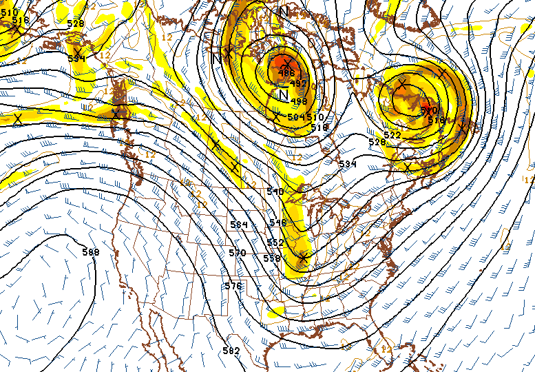
 With ridging going up the west coast, this allows additional shots of energy to dive into a deepening trough across the eastern part of the country this weekend…
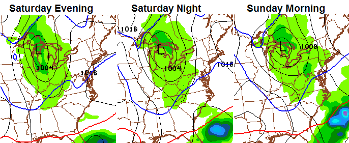
 The nest system will then work in for Saturday and Sunday with a reinforcing shot of cold and the possibility of some rain and snow…
 The pattern next week should grow even colder and has the potential to produce some extreme weather across the country. Blocking is showing up in areas that usually deliver cold shots our way. Throw this recurving western Pacific typhoon…

and you can get one major outbreak of fun and games in the eastern half of the country. Speaking of fun and games… check out the new December temperature departure from the CFS…
 Looks like the first half of winter is shaping up to be an interesting one. I will update things later today.
Have a great Monday and take care.

Wow, GFS is really itching at the cold air shots for next week. Its been consistent in bringing cold air thats probably about just as cold as we’ve just endured except it will last a lot longer and multiple systems will be sliding through. Yesterday’s 12Z ECMWF trended colder towards the GFS solution and since I’m posting this comment at this time, I have yet to see the 0Z run, and I wonder what the 12z run will look like also later today? Idk but I’m ready for cold and snow season to really kick into high gear later in December (If it does, hopefully.)
Dodger says welcome to winter! He’ll be looking for more frost and those beautiful snow flakes!
Hopefully this pattern show’s up in December when it count’s….But a couple feet of snow in November would not be bad either…Right super duper computer model????????….
Thanks Chris. We really appreciate it….