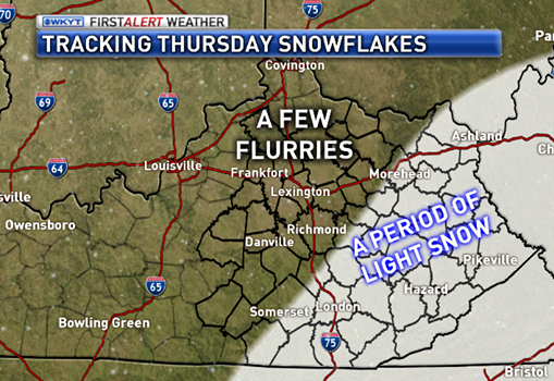
Good evening, all. Colder air continues to push into the state over the next couple of days as we are in a wintry pattern here in the middle of November. I’ve had a few reports of flurries out there today and Thursday should feature a better chance for some flakes.
Here’s a look at what to expect…
That doesn’t look like a big deal anywhere across the region. It does introduce even colder air for the next few days. That leads us into the weekend with the possibility of a greater snow chance. The first comes at us Saturday night into Sunday morning and looks rather light.
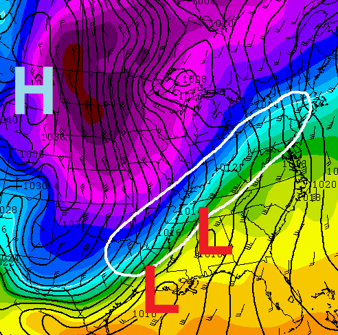
The second system rolls our way late Sunday into Monday. The models will continue to jump around with this system into Thursday. Here’s the main area of winter weather concern with this storm based on the European Track…
 You will also notice the next round of arctic cold diving into the plains. That arrives Monday night into Tuesday and could bring some serious cold our way!
As usual, a full update comes your way later tonight. Take care.

Chris, last time I remember a chance for snow this early put us in for a winter of big snows. Guess we will see what happens. Thanks for the update.
I think I’m going to go get my Thanksgiving turkey sooner rather than later. Too cold too soon.
My internet was down for 3 days and I came back on yesterday and saw all this very cold weather forecast for the next week or so,maybe longer and I went to the honeybaked website and ordered a turkey for Thanksgiving and a ham for Christmas.
With the way things are looking and where I am located on this huge,steep hill I decided I would get one now.At the time I need it I may not be able to get it delivered.
Chris thank you for all this information.Seems most sites are starting to agree with you that we have some extreme cold on the way for awhile to come.I am going to go back over the last couple of days posts and catch up on what I missed.
Saw one video showing all that extreme cold like in Colorado moving south and east next week.I am just not ready for this much intense cold this early but I am grateful to be able to find out about it in advance so I have plenty of time to prepare.Thank you so much for all the time and effort you apply to your forecasts.
Bring. It. On.
Lol
:))
Let it snow
Let it snow
Let it snow!!!
🙂
This is just bizarre! Our first accumulating snow potential of the season, in NOVEMBER, and only single digit comments….
Confused, but maybe it’s just everyone tweeting their thoughts!?!
Keep up the good work CB
Vinny I would guess that most are a wee bit snow-shocked! I’ll admit that this whole thing seems a bit odd.
Test
For over a year I was getting all my comments blocked by “Securi” or something like that. Not sure why nor how to make it “go away”. I tried again (see above) and … … Now I am free! Back in the game!
Oh – Looking forward to a snowy winter!
Bring it on! Snow a foot baby! 🙂
This very day 1 year ago was our first accumulating snow of the season in Northern KY last year FYI. I have pictures on Facebook to document! We had about 1″ or so… of course we had about twice as much snow as the rest of the state the whole winter, and we probably always will. 😉
chris bailey or any one else….can you please tell me how to bring the new gfs up…..i know how to bring up the old gfs but i can’t find the link to the new………thanks for your help.
Just watched wave3 news at 11. Kevin Harned says the models aren’t as bullish on the snow anymore.