Good afternoon, gang. It’s a cold and dreary day in the bluegrass state with low clouds hanging tough. That will keep temps in the 30s for most areas and it gets even colder in the coming days. The cold weather is a slam dunk, but the snow chances have been more of a three point shot. The latest versions from the GFS look like this…
They continue to bring one shot of light snow in from the west and southwest Saturday evening into early Sunday…

It’s the second system that continues to show up in impressive fashion. Here’s the new High Resolution GFS…
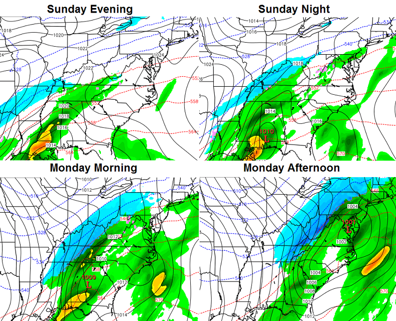
The “older” version of the GFS is similar…
Tracks like the one showing up on the GFS models are typically ones you see for decent snows around our part of the world. That’s just what each run shows…
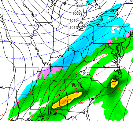
High Res
Regular GFS
Both runs are even colder with the air coming or early next week. Each show single digit lows with highs in the low 20s on Tuesday. For that kind of cold to show up, you would definitely need snow on the ground. I’m still not certain that we will have snow on the ground, but I’m leaning in that direction. Of course, that could be just a little or something like the models above show.
This is a very, very interesting setup to follow over the next few days.
I will have another update later in the day. Take care.

I wonder if any of that will eventually come to central Virginia?
I’m having a hard time reading the post… I keep hitting the “replay” button over and over again to see that winning shot! 🙂
you are not kidding!! I could replay that all day long and not get tired of it!
a BLIND SQUIRREL finds a nut every now then, so ROLO REDNECK WEATHER CENTER 4 days ago prediction might be on low end if it keeps growing stronger each run. still as of now a wide swath of 3-5 inches
I think 3-5 is an absolute best case scenario and could have the usual sharper cut-offs of totals for areas.
Seems the only given is there will be snow in the air and perhaps some on the ground. Still too early bank on anything.
While the modeling still looks good for most of KY, it’s getting increasingly worse/depressing for non-plateau sections of middle TN. So you guys enjoy and be thankful you don’t live down here 😉 It’s still very early, so overall, no point in getting too doom and gloom yet.
I feel ya pain here in Athens area..
Not getting excited. Too early just yet. Thanks Chris.
Don’t get all caught up in the model runs just yet. If the models are still painting a promising pretty picture for snow late tomorrow and Friday then I might buy in.
More like Saturday night 😉
More like the day of .
Or when all else fails we go straight into now-casting.
John Belski said the other day that if we actually got all of the snow that the GFS predicts, Louisville would average over 70 inches of snow per year. I’ll wait for the day or two out to get too excited. Regardless, any snow in November is just bonus snow. And yes, it was hard to stop watching that video.
Bowling Green to Ashland could be the winners when all of this settles down. Personally, I’m looking forward to the NAM runs as its 84-hour window may be able to sniff out what might happen with this thing.
Even if it does snow enough, it won’t do me any good since in 13 years I still haven’t located a decent sledding hill in the Hopkinsville area. 🙁
So if the snow chances are more of a 3 point shot and Aaron Harrison has the ball isn’t it pretty much a sure thing?
No, that depends on which Aaron Harrison shows up!
Thanks for the updates, Chris!
What’s this post about? I can’t get past the video
Wouldn’t the lack of a deep freeze on the ground melt anything that fell? I realize it will freeze in the next few days, but wouldn’t that latent ground warmth overcome any snow that fell?
Accumulating snow speak in November! It makes my heart weak!!! I like it!!!!! Woooohooooo!
It looks and smells like snow here in Londonia.
I was surprised to see the NWS forecast this morning for “today” that said decreasing clouds becoming partly sunny, especially looking at the satellite it sure didn’t look like a good chance of it become partly cloudy at all. It stayed thick overcast all day.
becoming
Alright gang don’t be stingy with the snow..send some to ya old blogging buddy here in east tn…lol…