Good Thursday afternoon, folks. Light snow and flurries continue to fly across the bluegrass state as temps struggle to hit the freezing mark. Think of today as a preview of things to come as I’m tracking greater snow chances and even colder temps. Is this really November?!
The first system makes a run at us Saturday night into Sunday morning with a weakening band of light snow. This may hold together long enough for some minor accumulations for some.
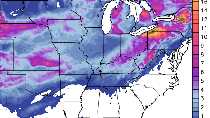
The bigger storm system continues to look very, very interesting for late Sunday into Monday. This one has the potential to bring accumulating snow to much of the region. The High Resolution GFS continues to hold steady with a similar solution to what it’s been showing for several days…

Here’s the snowfall forecast from this run…
The “old” GFS is playing into one its biases by showing a weaker, farther eastward system…

That’s been a bias of this model for a dozen years and one of the reasons it’s being replaced.
The Canadian Model has jumped into the fray by finally finding this system. Here’s the snow map from our neighbors to the north…

Keep in mind, 12 hours ago the Canadian really didn’t have much of a system.
Later tonight should find the models converging on some kind of a similar setup on the track and intensity of the Sunday/Monday storm. If they go in the direction I believe they will… hmm. Maybe? Just maybe a WST? 😉
The cold coming in behind this system looks wicked!! The Hi Res GFS lows for Tuesday…

And the highs…

That’s probably taking the cold to the extreme… I think. This is an absolutely crazy cold pattern across the country, right now.
Let’s track what’s out there today…
Current temperatures


I will have another update later today. Take care.

In other news, the ECMWF still doesn’t have a clue. See 12z runs. Goodness gracious…
Looking like a slight bump to the west is knocking London out of some of the accumulation…at any rate, winter is here. I think we’ll all get “the big one” at some point this winter. Have a great day. I really enjoyed this morning’s snow. Surprised to see it sticking to the ground some already. Could be a good sign for this weekend??
Well, though no way to really know what totals might fall- from a dusting to a few inches, it looks like snow day potential for Monday for some areas is “currently” in play.
Chris, do u think we will get the swing around effect here in se ky. Where we could see snow linger all the way into late Tuesday? Seems like that’s usually what happen here.
Will these systems have any impact on social activities for thosenof us who like to be out and about?
WST? Winter Storm?
WST = winter storm threat, meaning Chris may go into threat mode.
Thanks! I was wondering the same thing!
Thank you James!
The Louisville mets are still in a wait and see mode. The new GFS shows Louisville being in the heart of the snow, I hope so.
The gfs models runs I’m seeing for snowfall totals put the bulk of the snow in se ky on the edge of the Appalachians.
Im from nicholasville and moved to florida about 18 months ago , here in Miami it is 83 … i miss the snow
-14 in Denver this morning the coldest since the 1800s, now that’s saying something!
Getting light snow here in east tn..
Sunshine in Versailles.
Chris I’m a seeing some other forecasters are giving it to warm up next week 40’s rain and 60’s for thanksgiving you seeing this Chris because I’m not believing it until you say you are seeing what they are saying
They said the same thing about this week. 😉
That’s why this chick stick with mr.chris bailey
SE/E KY sweet spot for Sun nite Monday snow. 2-4 as of now could get more
That’s what I’ve been seeing rolo. I think it’s gonna be rain to snow but the snow will linger longer in this area
Depending on what model your looking at. The models today are enjoying waffles.
Another weather station is calling for 2 to 4 inches of snow in the Louisville area Sunday night into Monday.
That surprises me to give accumulations there’s just nothing set in stone. Will it snow? More than likely but to give accumulations in my opinion with the models waffling that’s a bit soon.
But…… if that station is the first to get the amount right, they will have bragging rights and we get to watch commercial after commercial on that particular tv station on which station was first to deliver the first accurate snowfall total of the season. It’s all about ratings when it’s all said and done.
I would say rain will keep the snow total’s down in Eastern Ky..Probably why you see more snow amount’s NW of us on the model’s…As for a warm up who know’s…It is still November after all and I’m sure you will see a relaxation of the pattern sometime…But that is probably what we want going into December.. reload for the big one when Climo is better..
The end runs of the NAM are beginning to pick up on the southern storm system that could impact our weather late Sunday into Monday.
At this time, I would not put too much stock into these runs either. However, it is just about good for comparative purposes now. I would give it another 12-24 hours though before we can make some definitive comparisons with the other models.
Well, these temps are crazy. Again, overcast all day and not above freezing during the day today on Nov 13th! At this point, nothing would surprise me. And Todd, that coldest in Denver since the 1800’s. Wow!
Well, picking up where we left off last winter-Louisville area gets the snow, and east ky the rain. Another fail of a winter
It’s still November Bryant…Wait til El nino kicks in with an active stj,tanking AO.. Got a feeling southern and eastern ky will be crying for there momma’s..
Saw snow flying here in Flatwoods off n on since abt 10am this morn!Yeah! I am ready for SNOW!
The newer version of the GFS sure has been steady…Basically look like no change…The older version still east and looks cold enough to give Eastern ky a decent hit..Just my take but that is why we have Mr Bailey to keep us weenies in check…
I love a good snow… but this is one teacher who does NOT want a snow day anytime BEFORE Christmas :X We only have 8 school days until Thanksgiving break and 23 school days until winter break and I hope we are there for all of them. Let’s just get ’em over with and not have anything to make up until AFTER the new year! *Fingers and toes crossed*
hello fellow readers.
it’s good to be back for another eventful season.
Love this time of year ( actually early I guess for this kind of snow possibility ) on the blog. Great comments and predictions and the excitement of looking for the BIG ONE! Heck, maybe more than one
“biggun'” ( credit to John Short ).
Sure was cold and stayed cold, caught a few flurries over by Commonwealth today.
More light snow this evening in London.
Btw…is it okay I post on here although I live 45 minutes from the KY border? As a TN resident, it’s fun to track with you guys, especially since many of you get more in one storm then we do in an entire winter!
fixing get sum Vigorous lifght snow as it hits up against mts. upping 3-6 swath Sunnite/mon
Little Rock had a little less than an inch of snow this morning. That’s their earliest measurable snow in over 60 years.
BTW, many of us may recall that Little Rock and adjacent parts of Arkansas had a foot or more of snow last Christmas day, places that are lucky to get a trace on any Dec 25th.
And in May 2012, the state of Arkansas had their latest snow ever recorded, their first recorded May snow ever.
Hmm, what does the “natural” state have that parts of KY and TN don’t regarding snow? 😉
I would just like to add that I love 3 updates a day.
Seconded! Thanks for the frequent updates, Chris!
well, if you are a fan of warmer weather, then you are surely a fan of Jay Cardosi. He basically said on the news at 6, we will be recovering into the 50’s by next Thursday. He went on to ad, there are signs of a pattern change, leading to a warming trend and getting out of the cold snap.
hmmmm……I don’t like to single out MET’s. Just saying, last winter, I heard much of the same. I’m not understanding why certain Louisville MET’s are so against the grain when it comes to winter weather and reading between the lines on the long (and even short) term indicies.