Good Monday, folks. We are counting down the days and the hours until the ball drops on 2015. The final few days of the current year will be on the colder side of the thermometer and the cold weather looks to become much more common into the new year.
Let’s start with our Monday and roll forward. Highs today will top out in the upper 30s to low 40s with mostly cloudy skies. Some breaks will be possible, especially in the west and north.
A weak disturbance will crank up just to our east later tonight into early Tuesday. That will try to throw a few snowflakes into the eastern half of the state. At this point, a few flakes look to be the maximum for most. Far southeastern Kentucky continues to have a shot at a period of some light snow.
Highs on Tuesday will be in the 30s with partly to mostly cloudy skies. The cold air continues to settle in for the final day of the year on Wednesday. Highs will be in the upper 20s to around 30 with temps ranging from the upper teens to the low 20s as we say hello to 2015.
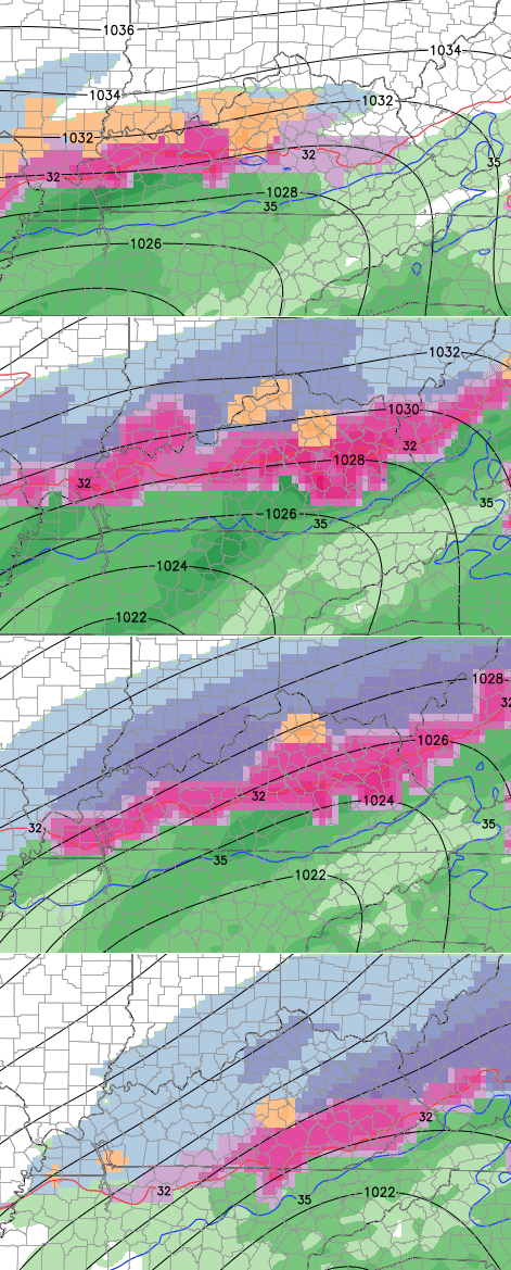
 It’s from this point we turn our attention toward the end of the week into the weekend. A TON of energy is coming across the southwestern part of the country. How all of it decides to come out will be the big determining factor on how things shake out around here.
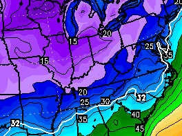
The European Model continues to show some overrunning mix to start things out…
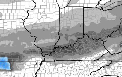
The new version of the GFS has slowed the process down a bit. It sends one piece of energy out later Friday into Saturday with rain and a mix. It holds on to a lot of that energy until later in the weekend and early next week. By then, colder air has returned from the north as the storm takes an eastward track well to our south. Here’s the end result from that run…
This is a very complicated setup that will be a pain in the backside to figure out in the coming days. I wish I could tell you how this works out, but I don’t want to lie to you any more than I already do. 🙂
I will have updates later today. Take care.

Bahhumbug on this weather!!! I want snow! Lol
isn’t 20s and 30s Normal weather.. now im not trying cause any trouble, but didn’t we forcast BRUTAL weather into January???
Yep, the models appear to keep pushing stuff out as each week progresses. A trend it be. Harrrrrr!
If the same thing happens the next week, seems it is what it is- Models talking smack.
Reading between the lines though, it appears the models still say “Fence” as far as south of I64. Whatever the case, proof is in the results!
Thanks Chris. Going to be interesting next weekend for some. From the looks of the maps we are in for, Wait for it…….a cold rain. Ah well that’s ok too I guess. Getting ready to cook Christmas dinner. At our house last night was Christmas Eve! Everyone will be here today to eat and open presents. Have a great Monday everyone.
Coffee lady I hope you have a very Merry Christmas with your family.
Have a great Christmas, Coffeelady! Enjoy your family time.
Midwest/west getting what we thought we’d get this winter. These lows coming up from the south aren’t good for snow events. Why? They bring warm air with them. Thinking this winter may be warmer than what was predicted.
They also bring the moisture we need for a good snow. I personally like cold rain more than Sunny and cold.
We rarely disagree- until now 😉
Lol…..I hate cold rain, but it really sucks to have a sunny 9 degree day.
Cold Kentucky Rain…
For a good snow, we need for the systems to come from the south. It will be interesting to see who is correct, because the Louisville Mets are calling for cold out breaks, but none that sticks around. Just cold for a couple of days, then a warm up. A mix to rain for this weekend with a cold outbreak, then warm up prior to the next system, but watching it.
I`m hoping Chris is correct, but I want a lot of snow.
It all a bunch of lies I tell you. Lies lies lies!
Thanks for the update Chris. I personally like the looks of the new GFS. Mixed bag to snow for the Ohio River counties.
Four of the five comments above are pessimistic. Why doesn’t anyone trust CB and his thinking. I am for one very optimistic about where this YOUNG winter season is headed and that is straight out of the late 70’s. The setup over the next week will bring winter to the Deep South by mid month and that WILL change some of the attitudes on this site, or not as you all now have Chris believing he is telling lies. LOL. Give winter a chance as it has just started.
THINK SNOW!
Not CB by any stretch, but the models are another apparent story. Unless a person has a memory that resets each week, the average of the models keep overstating outlooks for cold & snowy weather. Key part being “snowy”.
As far as snow, I can not recall any non-clipper event that was not overstated since 1998. Our biggest snows for Richmond since 1998 have been exclusively clippers.
Bubba, The biggest snow I have seen since my return to KY was Christmas 2003 – We hadn’t moved back yet but flew in for a visit. It began to snow on the way home from the CVG and we finished with about 8 inches and it stayed until after we flew out. We drove all over Madison county house shopping with a nice snow everywhere. …haven’t had anything like it since.
Was that a clipper event or a southern fed system? Do you remember?
It was a clipper with lots of wraparound action 🙂
Bubba’s lieing his britches off that was no clipper in 2003 lol
Oh, but it was.
That was a southern fed system there were documented reports of has much as 32 inches of snow just across the river with 2-5 foot snow drifts. Clipper my ###!!! Not even the strongest clipper on steroids can do that. That was a old fashion old school snowstorm.
I think all the storms this year have been complicated to forecast…I doubt that’s gonna change the way these models have been going
Ohio River counties seem to get the lion’s share of the snow last year, let them have the same with ice this year. Fair is fair.
Thanks Chris. I know it’s been a tough slog with predicting this stuff.
You’re doing a good job in pointing out what may happen. We’re still only a week into winter after all.
I feel certain we’ll get some good stuff come January.
And remember, according to George Costanza, “It’s not a lie if you believe it”.
Chris you do not tell us lies you only give what these models are saying I trust your forecast Chris so please don’t think that way you are the best at what you do most of these comment come from people who put you down for fun or something who knows what there problem is just know that the many people that are on this blog trust your forecasting so just keep up the good work and we all know how much work you put into this blog and I for one want to thank you for that we need this blog don’t know what we do without you Chris so you keep your head high and know that you are very talented
This has to be the longest sentence I have ever read.
Slow day?
as my grandpa used to say, “the weather will do what it does, no use in worrying about something you can’t control”
Chris, does this have the makings of an all-out ice storm for the I64 corridor?
Rodger says there’s nothing more depressing in the winter than a cold and dry period followed by a “warm up” to cold rain. He hopes this isn’t the total story with the weekend system(s).
The models have been too warm with their runs, so far this season. If they are showing freezing rain or sleet, then we may actually get snow from these or a quick change to snow. Our biggest snows have been surprises. If I remember correctly the 94 storm was earlier predicted as a rain event with less than an inch of snow or so.
Tim you are correct…the 94 storm was suppose to be light freezing rain changing to snow with a dusting to half inch. Surprise surprise….