Good Monday afternoon. It’s a cloudy and cold day in the bluegrass state with temps staying in the 30s for many areas. I wanted to touch briefly on the possibility of some light snow and flurries tonight across the east and southeast.
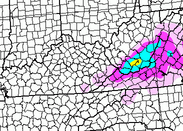
A weak system passes just to our east and will throw some moisture back into parts of our region. That means some light rain and light snow this evening with the potential for a period of light snow later tonight and early Tuesday. Far southeastern Kentucky could even see the tops of the hills whitened. Here’s where the NAM shows the best chance for that to happen…
I don’t have anything new on the end of the week and weekend system because it’s still very early in the game with that. I will have some new thoughts and model maps on that coming later today.
For now… track your Monday afternoon of weather…
Current temperatures


Enjoy the afternoon and take care.

Mets around here are giving us the blow torch for this coming weekend with highs in the 50’s Fri. & Sat? We shall see!
WDRB’s weather blog is saying this weekend could be a real concern. Kappell thinks the GFS is underestimating the cold.
I made a comment on the last post and I guess a couple of you think that I was stupid because I didn’t put my periods in you know I’m not going to put myself to your levels my saying bad things about you I’m just going to pray for you because you really need it and we wonder why this world is the way it is for our kids today pretty sad when you can’t comment on something without being made fun of will here you go boys you can do it again because no periods in this comment Chris just know I respect you a lot but I’m done with this blog I will still read your post but you really need to clean up some of the people on here and it’s sad that its people that have been posting on here since the blog started
Marsha, Marsha, Marsha!!
……………… Sorry! I had to add them mentally. The lack of periods really bugged me 😉 🙂
Lack of periods though is worthy of critique, since hard to read and appreciate the context of your post. Seems fair.
Cheese…chillax, lady! And you made yourself the ‘target’ when you decided to be unconventional or fashionable or whatever the motivation. And the ramble through the post with odd logic and poking at folks you have just castigated as doing the same to you…..pffffft! Period!
That’s my bad I do aplogize, wasn’t meant to be offensive I can see where you could take that comment as a offensive one. I own it. I’ll take my stripes. No harm was meant from it.
See below…ha ha
I don’t want to speak for others, but I’m pretty sure he was poking at you for fun, not to run you off this blog.
Regarding this weekend, it is going to be a mess to forecast and a big mess for whoever gets slammed with this mix and ice.
I’m willing to bet on a GLC this weekend with little to no frozen precip for my area. Just at not enough cold air established to battle the WAA that will be brought in from the south when the storm approaches.
Prelude 2004 storm is the one that dumped 30 inches on parts of southern Indiana Bubba just may have you on that one The 2003 storm dumped 2-5 inches here in Louisville and could very well been a clipper 2004 storm started as heavy snow and by noon was sleet here in Louisville with Heavy to moderate sleet until around two in the morning when it changed back to snow and Louisville ended up with 8 inches of snow/sleet/snow
And look no periods anyone care to comment on my long sentence
We got clipper wrap around from that and it was not just one system. Richmond area and Lexington have not had a southern fed big snow event since 1998. We have had a few ice ones, but not snow.
There have been a few over performing clippers with waves of wrap around.
Yup I stand corrected again it was 2004 not 2003. Oops sorry. Now I truly know how the GFS truly feels when you just can’t get nothing right. lol See I told Bubba he was 100% correct that it was a clipper system in 03 lol. Gotta poke fun at myself!!!
Well, I feel completely safe for the weekend.
WHAS11 in Louisille just said 45 and rain likely on Saturday. Just a light mix Friday night to start put and lingering showers Sunday morning.
She went on to say, bundle up if you are going out new year’s eve. But, all in all nothing major coming our way in the 7 day forecast. Her exact words.
Apparently they are banking on a Great Lakes cutter or just looking at the GFS from a couple of days ago. I never watch WHAS for the weather.
Is anyone seeing any decent snow chances in the foreseeable future? I’d even settle for some of those festive flakes we never got right about now.
We`ll see what happens, but Wave3 is calling for 40`s Friday through Sunday, with a lot of rain. Then 30 next week, with one day in the 20`s and another in the 40`s. Doesnt sound very cold to me, if this happens. The 40 degree day is probably our precipitation day.
I guess I can’t complain, i gave need a bengals fan for a long time..went through 15 years of lising, so last 4 years been, just frustrating when they look so good sometimes. Then just have a hard time getting big wins. It will be hard to go to indy and get a playoff win. But who knows..maybe….i guess I can’t complain, who knows what the weather will do in jan. Feb. And march. Wish it would snow soon here in Richmond.
hey everyone gave a safe new years holiday!
I live in the prime upslope area of southern wv we have had a good dusting this afternoon and still snowing at last check might get an inch or so tonight :0)
R.I.P, Winter 2014/15. You were D.O.A. As the experts predictions go up in flames (literally).