Good Tuesday, everyone. Clear and cold weather has pushed into the bluegrass state for the final few days of the year. While we enjoy a rare run of partly sunny days… it’s all eyes on a system set to impact our region later this week into the weekend.
The short term features an increasing amount of sun today with temps in the middle 30s for many areas. Gusty winds will make it feel even colder. Temps later tonight will hit the high teens in many spots and we could even have some single digit wind chills. The rest of the final day of 2014 features partly sunny skies will upper 20s and low 30s for highs.
New Year’s Eve party animals will find clear and cold conditions with upper teens and low 20s as the ball drops. New Year’s Day will see partly sunny skies with highs of 30-35 degrees.
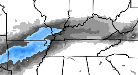
This is where the forecast become fairly murky. A southern stream storm system will develop ahead of energy coming from the southwestern part of the country. The latest run of the NAM offers a solution similar to what many models had been showing a few days ago. That is to bring a swath of frozen precipitation across the state late Thursday night into Friday…
 That run only goes through very early on Friday.
The new GFS shows much lighter precipitation in the form of snow and freezing rain…
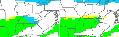 The model then brings the actual storm system into Kentucky on Saturday with a possible morning mix to start things out. The GFS goes over to rain and then has wraparound light snows develop for Sunday…
 Crashing temps and gusty winds show up on that run for Sunday. Check out where the numbers end up by the evening hours…

Just look at those temperatures showing up across the US and Canada… that’s some brutal air and really drives home the point on this setup going to opposite of December. Think of our November pattern on steroids and I think that’s what we are seeing evolving.
Just got a look at the latest European Model and has pretty much the same exact scenario as what we have showing up on the GFS. That certainly gives the solution a little more street cred.
Arctic air will then continue to move into the region following that storm and we will likely see a scenario with systems cutting across the arctic boundary to our south.
I will have updates later today. Take care.

What else is new, a cold rain again
Yep.
Positive spin: Non-freezing rain 🙂
That is about all the positive spin available 🙁
At the rate things appear to be going, even Lucy might get depressed. If people ain’t buying, no takers for the big kick whiff.
That would make Lucy, Chris. And those of us who try to kick the football, Charlie Brown. Getting your head knocked around by falling on the ground gets old after a while you know. Lucy gets an endless supply of footballs that always look just a little different but they have one critical flaw that deflates them like a dart’s crosshairs at a carnival.
Models are Lucy. Even CB is growing weary of the model misses, based on his progression of wording in each post.
Baloney is a better term.
ARTIC AIR?? isn’t upper 30s low 30s NORMAL AIR for winter. the ARTIC AIR stays NE/WEST of KY..
It is hard for CB to serve steak, if all the models are making for him is bologna 😉
What are the chances of this thing turning into an ice storm? I mean, we are still several days out, and Chris says the forcast is murky… He did also mention “frozen precipitation”. It has my curiousity perked because the models in yesterdays post looked like they could be calling for some ice, if im reading those correctly.
The model run he shows here accounts for cold air damming into WV and backside frozen precip into western Kentucky and Missouri and Arkansas. The beautiful fanning out of frozen precip on the last frame of that model run looks exactly like what a simulated radar around here usually looks when we’re on the fence for a frozen precip event. If that model run is to be taken seriously, it doesn’t show much for us, except maybe in the far northern parts of the state (Florence, Covington.)
Lol…..pattern coming will give northern Alabama/Georgia a greater chance of accumulating snows than us.
Joe T, I disagree. The cold will not go that far south. To much of a south east ridge to break down. The weekend system just may surprise some of us on the northern fringe, but what comes after that will be the real surprise. Gulf moisture with lows up the apps bam KY gets snow. Mid January into February will be game on.
Just for comparison sake, the Louisville Mets are saying there isnt a true arctic out break coming, just normal temperatures. The arctic air will split into 2 segments, one going towards the west and the other over the New England states, due to a ridge being over the Florida area. So this will lead to normal temps and more rain than anything, unless this southern ridge weakens.
We`ll see
Yes, get cold air in place and then a southern storm!
Thanks Chris.
Ditto!
CB is just calling what the models are showing, so suggest folks need to appreciate this.
I agree!!
If we don’t get any wintery precip this weekend, which is not likely for most, the next couple weeks don’t get any better with a zonal flow moving across the United States. Might just be one of the wettest
January’s in recent years. NAO and AO are moving back to positive and the PNA is going neutral for the first week of the new year. Still think the last half of Jan. into Feb. will bring winter back to the OV.