Good Tuesday afternoon, gang. Arctic air is controlling the weather across much of the country and that air is going to continue gain ground over the next week. These shots of air are already being felt across the bluegrass state. Wait, What?
The temps are already busting numbers from the computer models, as expected. This is modified arctic air that is pushing in here into Wednesday. Don’t believe me? Trace where it originated and also look at dewpoint temps tomorrow. The models are actually forecasting single digit and BELOW ZERO dewpoints. That’s of arctic origin, folks. You don’t have to have actual thermometers at a gazillion below zero for air to be considered arctic in nature.
Ok… rant over. 🙂
The storm system for the end of the week continues to look about the same as what it did with the last update. I actually like what the GFS is doing with some very light frozen precipitation possible early Friday…
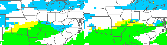
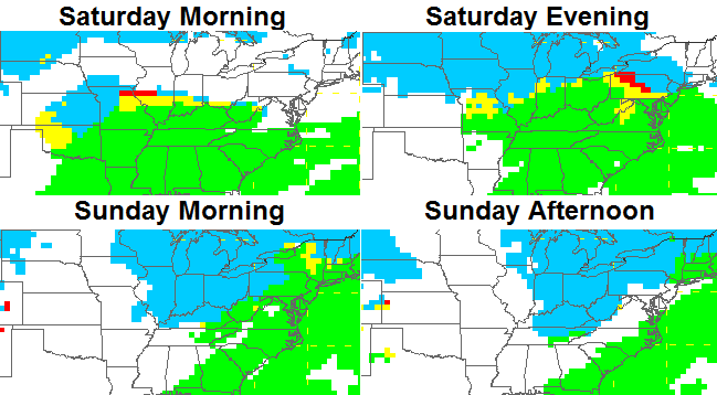
That action should dissipate during the afternoon and evening as our storm system gets set to work across the state over the weekend. That means a big temperature swing is likely with mainly rain and wind Saturday with crashing temps, high winds and snow showers for Sunday…
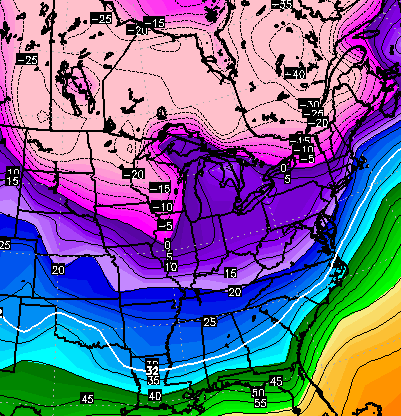
Check out where the temps wind up by Sunday evening…
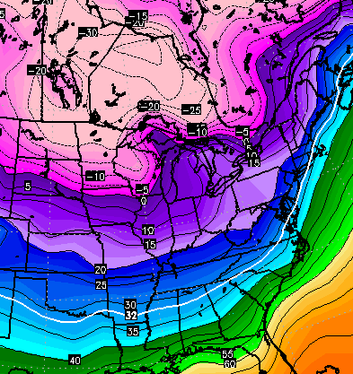
The Canadian Model is even colder with that air and takes temps even lower by Monday morning.
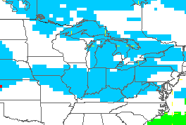
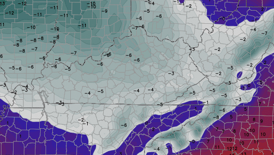
That’s when our arctic boundary continues to settle to the south with possible snow makers working along it…
The temps associated with that…
The new version of the GFS goes CRAZY cold…
Now… I don’t think things get THAT out of control, but arctic shots are lining up to invade much of the country.
I will have updates later today. Take care.

yeah, Artic rain. I think that’s are new slogan
Non-freezing rain 🙂
Must admit I am not getting a good snow vibe (even less than normal). I figured we would get a could few inch snows this winter south of the Ky river, but any thoughts of anything more would have to be pure surprise level.
Ice has me bugged though, but that is the way it is living in the Fencealachians . Made that word up…. fence and Appalachians…… get it? 🙂
Appafenchians?
luv ya Bailey, just frustrated ole buddy.
Uncanny though… Why do the model outlooks for this area virtually always understate snow, but very rarely overstate? That seems pretty consistent to me, so why no understanding of the reason for this?
We need someone with matrix algebra skills to solve this riddle! 🙂
Bubba, I may key word is (may) have some light at the end of the tunnel for you. The GFS is painting a decent clipper system one week from today. You can’t go wrong with a clipper system. Those are your favorite.
Prelude was going to say the same thing.
sorry but 30 degrees isn’t arctic air ….now the negative #s next week…that’s def qualifies as arctic air
I’m not one who usually believes in bucking up the troops, but it’s important to remember last winter didn’t really lock in until January 15 or so. There were definitely very cold periods before that, but there was also a lot of back and forth. Once winter came around January 15, it didn’t let up until Valentine’s Day.
To be sure though, last December was much colder on average. In Louisville, December 2013 was about .5 degrees above normal, but that was with a very cold start and a big pre-Christmas warm up. So far this month, Louisville is about 3.7 above average. That may drop a touch with this current cold snap, but only a touch.
Honestly, I’m a little perplexed and depressed by the weather so far. I’ve always paid attention to the SST’s and, in the Pacific, they are about as perfect as we could hope for cold and snow in the area. For whatever reason though, the pattern just won’t follow what the Pacific is suggesting. Usually, it leads the way. Figures it wouldn’t this time.
One culprit may be Typhoon Hagiput. When it didn’t recurve early in December, a super strong Pacific jet formed and warm air flooded the US. It didn’t relax for a while either. Also, don’t discount the Atlantic waters. They’re extremely warm up and down the east coast and that usually promotes a ridge. That may explain why there’s warmth along the east and cold hanging back in the west.
I’m not ready to throw my hands up because so many of the signal suggest cold (SST’s, QBO, Modiki El Nino look). Still, the pattern’s just not cooperating. If we get to the 15th and the MJO still shows warm phases, then I’ll start to panic.