Good Tuesday evening. It’s cold and getting colder tonight into the final day of the year. The big story continues to be on the potential for wintry weather on Friday and a big storm system for the weekend.
The models continue to point toward overrunning wintry precipitation moving in Thursday night into early Friday. That could be in the form of freezing rain, sleet, snow and some rain. The latest European Model is pretty enthusiastic on the potential…
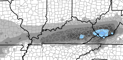
It just takes a small amount of freezing rain to cause some big travel issues. That possibility is something we will need to keep a very close eye on going forward.
The rest of the weekend forecast remains the same. The next wave of precipitation moves in Friday night and could start out as a mix across the north. Rain takes over and could be heavy at times with gusty winds and spiking temps on Saturday. The low goes by and temps tank quickly with some snow showers and flurries into Sunday.
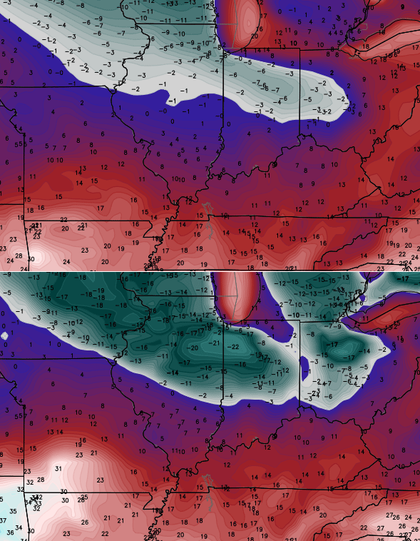
A couple of clipper systems work in next week as arctic air continues to take control of the country. I’ve shown you numbers from the GFS family… the Canadian model shows some very cold stuff, too…
 Enjoy the evening and take care.

For all that cold air, sure is a lot of mix & rain. Boo to 33/32! Especially that ice part 😉
Towel thrown in on this scrap heap of a winter. Models have been horrible. Snow cover across usa is puny. Nothing but clouds, rain and gloom. To add misery, flu is rampant in KY. Spring cannot get here fast enough
you must lead a very measurable life, so sad
Guess you buy into this garbage that winter weather is 7 days away
I agree, keep saying Winter is 7 days away for the past month. I guess if it is said long enough, sooner or later it will come true. My guess is later….much, much, much later….like next December.
Garbage?
the models, cb, the models. You have not control of the weather, you are just cursed with not having much to work with in regards to medium to long range outlooks.
Lol is this your first post ever on this blog? Don’t personally attack people. Bryant is merely stating how many of us feel about this winter thus far.
That was not his 1st post he is a long time and very respected blogger.
Correction. Vinny used to post with regularity, but has not posted in forever. Second, getting attacked for expressing an opinion is pretty bush league, IMO. This weather is God awful and, having lived here for 40 plus years, I can say it’s on pace to be one of the most underwhelming winters. You guys just want a fair weather fan club.
If your prognostications don’t come true again this year, please spare us all (and especially CB) the apologies like you came back with last winter with your tail between your legs. You would think after your blowtorch predictions last year that you would have a little humility about you, but I guess not.
Get over yourself. I stated that if anything, I was happy to be wrong.
You called me a troll once, SHAAK and without any reason whatsoever. Nice lecture, though. 😉
No there had to have been a reason or I wouldn’t have said it.
I can not see anything incorrect in his post as far as the weather so far and the outlook. CB’s outlooks concurs.
I think we should all where Johnny Cash black and just roll with it. Instead of a boy named Sue, we have models all named Lucy 😉
wear…. oh, whatever 🙂
Happy fingers.
Hey vinny long time! I was thinking about u the other day wondering how max is…hope yove had a great holiday. ..
Artic rain. You gotta love it!
Bengal it’s spelled “arctic”. 🙂
AKA: Non-freezing rain
If the media and national mets can collaborate to create/concoct Polar Vortex, I can go low rent with Non-freezing rain 🙂
I really enjoy Bryant’s take on the weather..Maybe we will be reduced to a dumpster fire this winter instead of a blowtorch..Bring on the New year..Rain,snow,sleet,freezing rain or 70 degrees bring it on..Just be thankful were still around to enjoy what mother nature throws at us..It’s only weather..
I’ll take cold rain over freezing rain any old day. Doesn’t bother me a bit that the models have mostly backed away from the sleet/ice mess that they’d been predicting. And if Saturday indeed reaches into the mid-40s to around 50, any ice from Friday night shouldn’t linger very long.