Good afternoon and Happy New Year! Thanks to each of you for making 2014 the most successful year we’ve had here on KWC. Every month featured record traffic and you guys are the backbone of what we do here. You guys rock and I’m grateful for each of you.
Let’s get into the weather part of the program and leave the sap behind. 🙂
A light wintry mix rolls in from south to north later tonight into Friday. Light is the key word, but it doesn’t take much frozen precipitation to cause some issues. The GFS shows the entire region getting in on, at least, some frozen stuff through Friday night…

The first wave comes later tonight into the morning across the southern half of the state. A small break in the action will be possible during the afternoon before another round of a mix and rain develops during the evening and night. That may have a greater impact on the northern half of the state. Light icing is a possibility for some areas.
All of that goes away VERY quickly on Saturday as mild air surges in. Rounds of rain and some thunderstorms will roll across the state with temps nearing 60 degrees. Gusty winds of 30-40mph will be possible.
The cold front swings through here early Sunday with crashing temps behind it from west to east. Morning temps will be much, much warmer than what we end the day with. Snow showers look to be a good bet during the afternoon and evening as the cold slaps us in the face.
That shot of arctic air is showing up colder and colder on the models and the Canadian is super ccccccold….
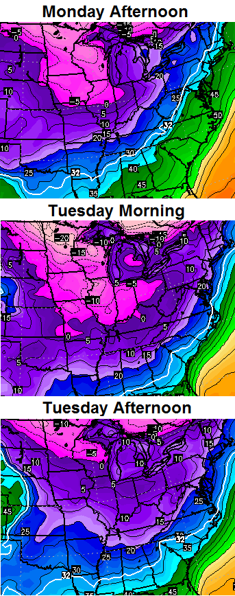
A clipper comes in behind that late Tuesday into Wednesday and could bring a swath of light snow across our region. The air coming in behind that is even colder.
A day or two in the teens with single digit lows are very possible next week.
Again… this is a complete and total reversal of the pattern we had in December. I will try to update again this evening. Happy New Year and take care.

THANKS FOR THE UPDATE ON THE WEATHER CHRIS THIS WILL BE A MAJOR KEY FOR ALL EMERGENCY SERVICES TO KNOW WE COULD HAVE A BUSY REPONSES FOR THE WEATHER CONDITIONS.
But still no big snows within the next 384 hours….(16 days)
What happens when you have an urban area and no restrictions on fireworks for one time a year? New Years Eve in Manilla!
This is also how I imagine the blog whenever we finally get a STATE-WIDE snow of at least 3″.
http://youtu.be/HKbTn_J7zoE
That was seriously awesome. Thanks for sharing that.
Awesome!!! Thanks for sharing.
Happy New Year guys. Thanks Chris for your hard work and dedication. May we all get the weather of our dreams.
Happy New Year Chris and Thank You for All you Do. Please get some snow down Somerset way, we keep being left out!!!!!
Sad when a 1 and 2 inch snow would be rejoiced and look foward too. When we was growing up a 1 and 2 incher was small and common. Now its considered decent snow.
Blame the southern feds, since they were our source for big snows, a lot of us have only resulted in big ice several times since 1998.
As others have pointed out too, I think we need to bank on clippers and hope for several wrap around waves. Those have been the only source for snow above several inches for many of use folks from just north of the Ky river and on south.
Southern feds based on their history since post 1998 have so far not been big snow, but big ice. That or mix events.
“,” should have been “for”. Oh well… It IS recovery day for some of us 🙂
hey CB tis is indeed ARTIC AIR!! sorry I ever doubted u Boss!!!!
For now it’s off on its own, but the GFS and its ensemble forecasts show the MJO moving into phase 7 by mid month. The Euro also shows very cold weather around the 10th and each run seems to get colder. Quite a flip from last week.
http://www.cpc.ncep.noaa.gov/products/precip/CWlink/MJO/CLIVAR/clivar_wh.shtml
That works well if out of the 33/32 rut for moisture.
It is a coming as I have been saying for the past couple weeks. Winter just started give it time to sink in. Cold and snow on its way. Just be patience. I also only speak for us in Louisville the 33/32 formula will work out for the rest of you.
OK… Phase 7? … I am sure I speak for most when I say: Huh? What’s that all about?
It’s 7 days or better from now so who cares.
Sorry but my sarcasm is a direct result of Alabamas pitiful performance the last 5 minutes of this game.
Yep not much going our way these days boys. Winter weather is wimping out. The SEC looks to be fading in the playoffs. Oh well, still got Cal’s platoons and I think Mark Stoops will have the Cats winning 9 next year. I know that will make Bailey boy happy
Look up Madden Julian Oscillation….