Good Thursday and Happy New Year! It’s full steam ahead into a brand new year of weather and things are starting off with a wild temp swing ahead. That temp swing will bring a lot of different weather to us in a short amount of time. For the longer haul… it’s all about the arctic cold.
Today’s weather is nice with highs in the 30s and clouds on the increase. Those clouds will likely throw a wintry mix of precipitation into parts of the region later tonight into Friday. That could be in the form of some freezing rain and that could cause some travel trouble spots.
The GFS shows this developing…
I will get more specific on this later today.
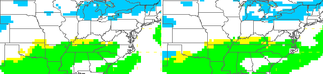
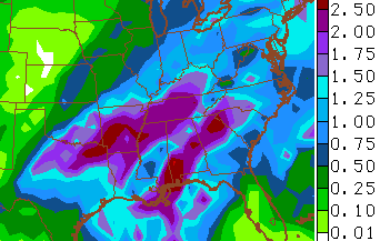
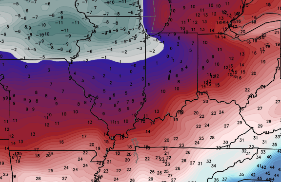
A big area of low pressure then swings across the region on Saturday with temps surging toward 60 degrees. Heavy rain, thunder and lightning and gusty winds will highlight the day. Check out the precipitation totals from the Gulf into the bluegrass state…
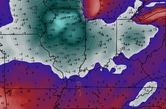
As the low swings by to our north and northeast early Sunday, our temps will CRASH from west to east as arctic air surges in. Check out the difference…
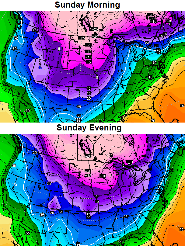 That’s a dramatic temp drop to go along with gusty winds and the increasing threat for snow showers or a period of light snow…
Arctic air continues to filter in here on Monday. Look at the afternoon temps showing up on the Canadian Model…
That’s some wicked cold showing up just to our north and west!!
Another arctic boundary pushes in for Tuesday as a clipper zips across the Ohio Valley. That could bring the potential for some snow our way.
The air coming in behind that looks even colder. The Canadian Model continues to go hog wild on the cold…
I am not saying things get THAT cold, but you certainly get a good understanding on the pattern we are dealing with.
I will update things later today. Have a wonderful start to the new year and take care.

30 s one day….40 s the next….60s the next….CRASHING temps to the 30 s the next ?? LMAO…this is the new normal. There’s no way we have prolonged periods of snow in Kentucky anymore…maybe an inch overnight that melts before lunch LOL….face it folks, we are in the New South. 🙂
And if I’m a “hater” for telling the truth about our weather from now on so be it. The biggest fear of our winters anymore is “Gusty Winds”….OOOOOOHHH 🙂
Old school winters are a thing of the past here in KY. There’s clearly been a warming in progress.
As always, and this is for my haters, I’m taking bets that Jackson and London finish <10" of snow for the winter. I like my odds
Contact Rolo!
Don’t feed the ignorant people who think they are being truthful, but in reality are just blithering ninnies.
Couldn’t tell you the last time I seen a snowfall map. Would be nice to see a big one on the horizon but not looking good.
Happy New Year all. Crazy weather in Kentucky. Now if we can crazy up some snow when the cold settles in!
People who are crazy dont know they are crazy. I know I am crazy therefore I am not crazy. Isn’t that crazy? 😀 😀 😀
That’s Catch-22. The best one there is 🙂
Folks I have been watching survival shows about Alaska, and people living in or near the arctic have talked about the way the climate has changed there. They are also having constant weather swings, just like us in the winter
Snow? What’s sno…oh wait, I remember snow, I saw the smallest of dustings back in October. Ahh, the gold ole days.
#Madisonresidentsunderstand
Test
Happy New Years all, my long write ups are not posting. Oh well…
You to Vinny
Hi Vinny. The KWC auto-mod deletes posts that have “objectional” words. Unfortunately, it’s a bit overkill at times. For example, the word c*l*a*s*s (like in a school) is flagged by the auto-mod. Same with D*i*c*k*s*o*n County, Tennessee.
Thus, one has to either use different words or insert the equivalent of ” * ” marks between the letters.
cold Wednesday …cold Thursday….warmer Friday as the precip arrives…a lot warmer Saturday when the motherload of precip is on top of us….crashing temps sunday as the precip leaves…..new year ,same song and dance
I personally hope it is the same as last Jan/Feb here in Louisville we received more snow than in years past.
oh I almost forgot , then the arctic air arrives with clear skies
Well, the temps last night didn’t go nearly as cold as was forecast. Cloud cover?? I hope we can get through January without big snows and the cold like last year. It was a retail killer. Everyone stayed in and no $$ was being spent. Economy killer and my bonus was dried up. Weather is simply an economy killer unless you do snow removal. Not to mention, a warmer winter will save lots of folks big $$ on heating bills
Regardless, I want a ton of snow!
All the people who claim “warming” must have forgotten about last year.
2013 was the warmest year on record and will be eclipsed by 2014. Last winter was exceptionally warm worldwide, save for the eastern section of North America. As “cold” as it was last winter here in Louisville, not a single record low was set. As I type this, it’s raining in Anchorage, Alaska. They haven’t dropped below zero in over a year.
some people think with their heart.
some people look at the evidence and come to their own conclusion.
eventually the truth wins no matter how much quack science=money is put in the pockets of government leaders.
Well said.
I agree
let the Clipper mania begin.
its January time for the nickel and dime snows.
We are only 10 days into winter give it a chance. I personally believe we will have several nice snows here along the River in Louisville.
Thanks for the update Chris and Happy New Year to all.
I hope 2015 brings lots of snow to the positive ones and cold rain to the negative Nancy’s out there. Ha ha!!
Happy New Year CB and the Kentucky weather family.
Rodger says this winter is disappointing. Sorry, Mr Bailey, cold without snow is boring. Thanks for this blog, however. Rodger!
It is must be hard for CB to post the no-snow weather to a snow lovin’ crowd. Again, it is like a chef trying to serve steak when all he has in the kitchen is baloney.
The positive could be we are better off with no snow than the little accident inviting, salt crusting one & two inch events. A decent three inch or above snow, or nothing IMO.
Happy New Year!