Good Friday afternoon, gang. The light wintry mix from earlier in the day is giving way to showers that will increase as we head into tonight. That takes us into a wild weekend of weather that will feature thunder, mild, high winds, cold and snow showers. Oh and the arctic attack for next week continues to look very stout!
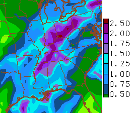
Heavy rain is a good bet across the state through Saturday night. Check out the totals from the GFS…
Some of those rains will come from thunderstorm action late Saturday into Saturday night. We could even see a squall line working into the region as the cold front swings in. Wind gusts may top 40mph later Saturday into Saturday night.
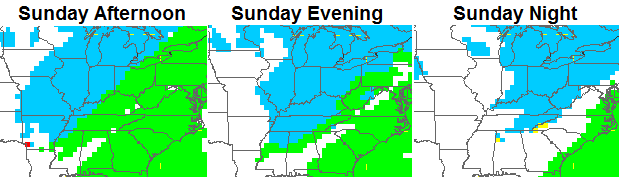
Temps will reach near 60 on Saturday and the crash down from west to east on Sunday. Wraparound moisture will be in the form of rain showers in the morning with snow showers kicking into high gear during the afternoon and evening…
The next system arrives Tuesday as a clipper brings some light snow our way. The true arctic front sweeps in Wednesday with falling temps. We may see afternoon temps falling into the single digits! The new version of the GFS is crazy cold…
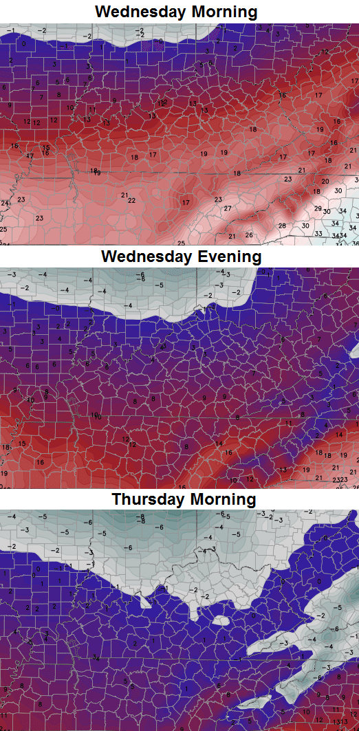
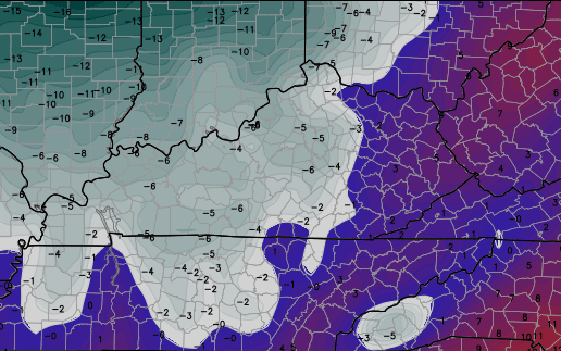
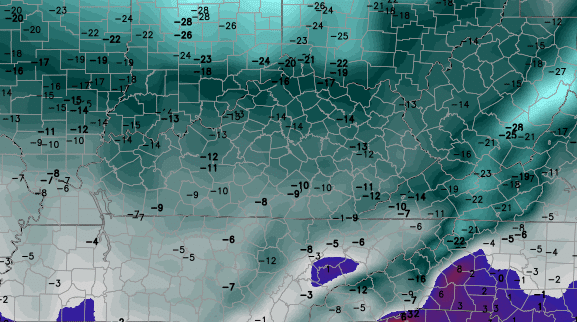
The Canadian Model is even colder for Thursday Morning…
That’s just crazy to see considering the models aren’t showing much, if any, snow on the ground. If the Tuesday clipper can deliver some snow… look out.
Something else to look out for is the wind chill. This would rival some of the brutal days of this past winter…
 While I am confident we have a significant blast of arctic air coming, I’m not going as cold as what the models are now showing. Still… I’m not too far away with a arctic attack that will make headlines in the week ahead.
Watch the system that follows this up late Friday into Saturday.
I will update again later today. Have a good one and take care.

Thanks for the update CB. Hope you and everyone else is off to a great 2015.
What is CB talking about, artic air??? Im seeing nothing but 50’s and 60’s next week blowtorch weather. Just kidding looks pretty brutal temp wise pipe bursting weather returns.
If it happens it will be similar to last yr we had several cold days with bare ground last yr.
Hi Andy. Hope you had a great Christmas and New Year.
Same ole, same ole. Locals where I live have 60 degree rain this weekend followed by a 3 dry days in the low 30’s, followed by back up to the 50’s with rain next Friday. Nothing new there same pattern we have seen all Winter.
Jimbo, what part of Kentucky are you at?
Near Ashland
I am NOT liking this talk of brutal cold. I’ve had enough of that after last winter.
this is the same arctic air that was supposed to have shown up Christmas week…blowtorch happened……I guess if u keep calling for arctic air every week , u will hit it eventually lol
I will have to give credit to Bailey. At least for my area he was spot on for the November cold and the temperatures busting colder for early December. And I have seen a fair share of pretty cold forecasts for the coming week from other places. Might be actually going back to a much colder pattern.
Do you enjoy posting here?
I know it’s going to be cold next week, yet very dry. What are the long range models showing towards the middle and end of January? If it doesn’t snow in January then I just say bring on an early spring!
We have had our share of wintry mix today – cold rain and then cold with no rain, followed by more cold rain.
The Britts have a word they use to describe this type of weather – dull. In the UK “dull” means cold, gray and damp in the winter. In the summer “dull” means not as cold (not warm mind you, just not as cold), gray and damp.
This winter has been, well, dull. (So far…)
Dreading the cold already, hopefully it won’t be too prolonged.
Bring on the brutal cold and a foot of snow!
Gosh Chris Bailey, why wont you make it snow?? Especially since you, and you alone control the weather! Stop teasing us and send some snow our way!
I am so mad at you right now because you control the weather all by yourself and you wont make it snow!
How dare you give us weather maps showing warm weather! We are not fools!
We KNOW you control the weather! You cant keep it a secret from us!
…just kidding.
But seriously, we know.