Good afternoon, gang. It’s a windy and a mild day across the bluegrass state with plenty of sun to go around. Get out and enjoy what’s left of it… changes are ready to blow in for Sunday with more winter lurking into the week ahead and beyond.
The front comes in late tonight and early Sunday with some rain and snow showers. Winds will continue to be gusty with temps in the upper 30s for many.
From that point… it’s looking more and more like we will be tracking several systems in from the northwest. That’s a pattern that has been non-existent this winter and is one that usually brings snows our way. Our first system rolls in on Tuesday with some rain and snow showers. A period of light snow and flurries will then try to kick in for a couple of days afterwards…
 That’s from the morning run of the GFS and that same run brings a clipper in here by Friday…
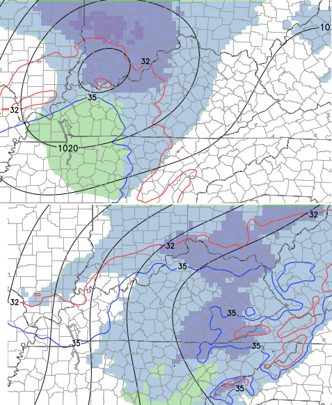
A few days later comes another clipper on the European…
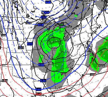
It’s a pattern that trends colder with each passing system and is one that likely opens the floodgates to arctic air later in the month into February.
I’ll have a full update later tonight. Enjoy the rest of your day and take care.

enjoying this 40 degree warmup today
Bring on Spring! Enough grey rainy crud lol.
My therm outside actually cracked 60 at 3pm but the winds have since cooled it down to 57. SE KY looking good for the week … No snow mentioned, Monday and Tuesday both looking mid 50s, Wed thru Fri upper 30s, low 40s ……. I’ll take it for 3rd week of January.
has clipping mania begun?
Wienberg said last night no snow for the next 7 days lol.
he is such the drama queen.
although I will give him credit, he can turn a clear boring sunny day forecast into Armageddon day.
Here is what Ole Andy W . posted on FB about 30 minutes ago…
We are on pace for the least snowy January ever and I don’t see any threats the next week or so. We will see a series of weak pacific based cold fronts this next work week. One arrives late tonight, another on Tuesday and a third on Friday. They are only capable of a few light rain showers and maybe some flurries at the tail end. The type of cold we have seen frequently this month is not available right now. Look for near to above normal temperatures most of the week.
Enjoy the warm temps over the next few days. Cold air is about to come back with a vengeance through Feb. I hope we can get a few systems to run up the apps in this time frame. Thanks for the update CB.
An Apps runner? What’s that? I think Mother Nature decided those are extinct?! 🙁
Long range predictions for February have changed from colder than normal to normal for February. I will take a normal 50 degrees for a high in mid February. We may still get a big snow, but it wouldn’t hurt my feelings to get a few more 50+ degree days like today.
Beautiful day, but really hoping for some snow in Somerset.
We had two days of extremely light flurries this week in Monticello…we haven’t had enough snow to even make a snowball this season. I can’t ever remember a winter where we didn’t have at least one wimpy ankle biter on the ground…could this is one be looking historic?
Unless one of these systems over performs, we could be looking at some record low snow totals this far into meteorological winter. We may get a whopper before the season is over, but this has to be one of the most boring winters in years. Not even the infamous 7 day out storms showing up on the models.
“That’s a pattern that has been non-existent this winter and is one that usually brings snows north of the Kentucky River.”
FTFY
I watched a couple of vans almost get blown off the road around on 64 at Olive Hill around 10pm. That wind is ridiculous is places and no advisory.
Very unique-looking radar signature tonight.