Good Saturday to one and all. We have a preview of March weather out there over the next few days. Gusty winds and milder temps will be in full swing out there today and this will undoubtedly cause a minor case of spring fever. Get out there and soak it up because changes return to close out the weekend with more arctic air lurking later next week.
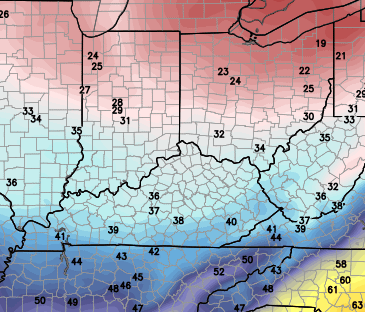
High temps today have a shot at hitting 60 degrees across the west and south with the rest of the state in the 50s. Gusty winds will be the only drawback to the day. Those winds will remain very gusty through Sunday as a cold front sweeps in. Showers will increase during the afternoon and evening…
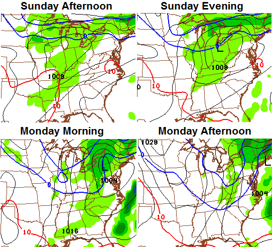
Much colder winds will blow behind that front and will push our temps down into the 30s for afternoon highs on Monday…
 A few light snow showers or flurries will be possible as northwesterly winds kick in.
Temps will bounce back up for late Tuesday into Wednesday, but a massive dip in the jet stream will develop by the end of the week. This should allow for the floodgates to open from the Arctic with several cold blasts into the eastern half of the country. The GFS continues to go crazy with these blasts. The first arrives for the second half of next week…

The one that follows that up for Valentines weekend shows up even stronger…
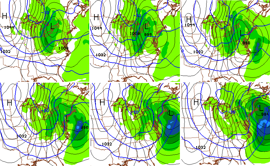
That would certainly qualify as a deep freeze if it develops the way the models forecast. As always, we shall see.
I will have another update later today. Make it a good one and take care.

Not many snow chances huh? Oh well……
More dry cold, probably.
Can’t wait for that cold dry pattern to show up for a couple days then mild then cold…lol. Our Winter of 1991 “the sequel” rolls on. I will be interested in the Winter recap as all the mets try to show that Winter overall was colder than normal and we were so close to a good snow pattern….
TnT, I sure hope not. Sometimes it’s best to admit that you lost fair and square. Nearly every met was going with a cold and snowy winter this year. It’s not happened, and probably won’t. But now I see that Brian Goode is already riling up the WAVE3 faithful about a potential system on Valentine’s Day weekend.
This has been a failure of a winter, and, yes shades of 91 and 89 come to mind. After walking outside in the sun and warmer breeze, I wish winter would die a sudden death. In the event it does not, I’m in Georgia the week after, you guys can enjoy the cold, because you can sure bet it won’t snow.
Snow won’t happen next weekend! Please, oh please If Models show any hint of it, don’t say potential!!!
Even if they do show snow now, by about Wednesday it will be rain 50 degrees followed by quick temp drop backside flurries. It is really has been an easy Winter to forecast. Just put out the same forecast a couple days before the storm. Wait about a month and you can drop off the backside flurries.
The trend says little to no snow and has absolutely punked the models this winter.
I also notice CB isn’t mentioning anything about storms a week away. I guess this Winter has gotten to him as well. Shows potential a week away only to be much a do about nothing.
Last February was the same.. Cold and dry.
Rodger’s “enthusiasm” for this winter is gone. Too much disappointment and too much dry cold and rain. NOWCASTS are the only “models” he believes anymore. (And yes, Rodger knows NOWCASTS are not models)!
While everyone else complains of no snow and the God forsaken worthless models (which they are), I’m simply going to say that this is an absolutely beautiful day and hope everyone enjoys it as much as I will!
57° in Crab Orchard right now. Enjoying it! 🙂
So is that your version of ” bring on spring ” ?
Just saying.
Nice try, buddy, but no.
Go away troll.
I’m not a troll, SHAAK.
The later it gets into February the more thought s of spring and fishing and enjoying warm weather is hitting home!
One big snow and I’m all good, if not theirs always next year LOL 😉
Thanks Chris. I see a few more are getting into Spring mode. After today, how can you help it? It’s gorgeous out there! Enjoying all of it that I can. Don’t forget, DST is only about 3 weeks away! Spring can’t be too far behind! Have a great Saturday everyone and GO CATS!!!
61 here in Carrie of knott co. Great day
Bright sunshine and 64 in London. Awesome day !!
Local Met here in Huntington WV went from predicting 2nd half of February very cold/snowy to giving up on snow in less than 24 hours. He seems ready to throw in the towel like most of us already have. One more thing, Huntington still on pace to set a record for least snow, we have 1 inch right now. Current record is 1.4 inch we could very well set a sad record this year.
I didn’t see it lol but im not surprised
Today has been a beautiful day! Lots of cars got washed and people are out in force getting all kinds of shopping and errands finished. Gotta love it! Does make us wish for spring….but as contrary as this winter as been, I don’t think it’s over. More is probably on the way just because we’re looking for a little bit of spring. Contrary weather!
Indianapolis Wal-Mart before their last “blizzard”…
http://imgur.com/mTRaKtL