Good afternoon, gang. Some clouds are hanging tough across central and eastern Kentucky and that is slowing down our better weather talk. Hang in there, it does get better later today and into Saturday.
Talk about a frigid morning, we had it out there today. Many areas hit the single digits again with a bare ground…
It should be noted the absolute coldest model forecasts I saw for this morning only had upper teens.
For the rest of the day, skies will SLOWLY clear up a bit. Temps are going to be held in check and several degrees colder than I thought across central and eastern Kentucky. Some areas will struggle to get above freezing.
The model numbers for Saturday are coming in a little colder…

That’s still much better than we’ve had.
Another system dives in on Sunday with gusty winds and a shower or two. Temps will spike ahead of this and then crash behind it…
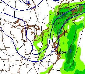
That could lead to a few snowflakes with temps in the low and middle 30s.
Another bounce back is likely by late Tuesday and Wednesday, but arctic air looks likely by the second half of the week. Check out the blast arriving on Thursday…
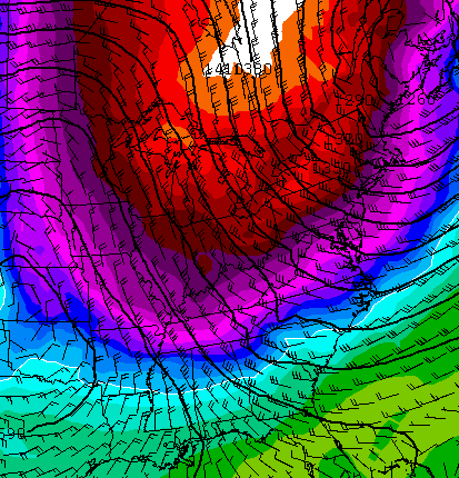
Can we get some snow to go along with that blast? I guess we shall see, but it’s one in a series of arctic air masses diving into the eastern part of the country in the coming weeks. Btw… the shot above would deliver more single digit lows to the bluegrass state. Just what we need… frigid temps and a bare ground. 😉
Make it a great rest of your day and take care.

My part of Knott County hasn’t had 2 inches of snow thus is winter.
Just keep the tiny snows away. Very demoralizing seeing more salt on things than snow 😉 ….. 🙁
That
BOO, I for one am ready for spring
Ready for warmer temps and outside weather! This winter had been even worse for snow than last. We can’t even get a coating here anymore. Ha!
A coating has been it for middlesboro. We never get much but this year has been pathetic.
I believe we will get snow on Valentine’s weekend. Snow lovers be on the lookout. Snow is on the way.
Rodger disgusted with the same old, same old. Cold and dry, warm and rain. Yep, and more salt on roads than snow. Can’t remember a more disappointing “winter.” Rodger in Dodger!
don’t know why chris is going in spring mode so quick……we still have at least a whole month to go yet of winter……maybe if you guys would not go into winter mode as early as november then maybe it would not get old……like i asked before……..what is the difference in getting 50 and 60 degree days in jan. and getting 20 degree days in march or feb.?
Yup.
CB indicated in the post, more bitter cold on bare ground. Seems he is resigned to the fact the pattern just can’t be broken. Technically, yes over a month of Winter left. Realistically just about 3 weeks, snows harder to get and melt very fast in March.
Our only snow of the winter melted very fast, and that was the middle of January. Up is down and down is up.
I like the idea of a snowy Valentine’s weekend…let’s shoot for that one.
I like it too. But the chances of that are slim and none. Unless you count the dusting from the backside flurries
Amen to that!!!
I’m tired of this weather we’ve been having. The cold this morning was miserable. I’m ready for sunny days and day time highs in the 70’s and 80’s.
I go to school in Harrison County. We’ve gotten plenty of snow on our part, but last year we got WAY more. Anyway, I hate snow. I’m SO ready for summer!