Happy Friday, folks. We’ve made it to the start of our weekend and it looks like a nice surge of some milder air is blowing back into the bluegrass state. This begins another up and down temperature pattern through early next week. The longer range look continues to try to bring arctic attacks into the eastern half of the country.
Temps are downright frigid early this morning with a few spots possibly in the single digits. Sunny skies will help give us a nice recovery with afternoon readings hitting the upper 30s to low 40s for most areas. Bump those numbers up a few degrees in the west and south.
High temps by Saturday surge well into the 50s on a gusty southwesterly wind. Skies will be partly sunny and this looks like a fantastic day to get out and enjoy.
I continue to track a system diving in for Sunday and Monday. That should be a pretty decent wind maker with a few showers pushing in for Sunday. Much colder air will follow that up by Monday and we could see some flakes flying…

That’s a quick hitting shot of cold and flakes behind that. Temps should rebound quickly by late Tuesday and Wednesday. All of that still looks to set up shots of arctic air invading much of the eastern half of the country. These are likely to come at us every couple of days. Check out the massive temperature departures showing up with 3 different blasts on the GFS Ensembles…
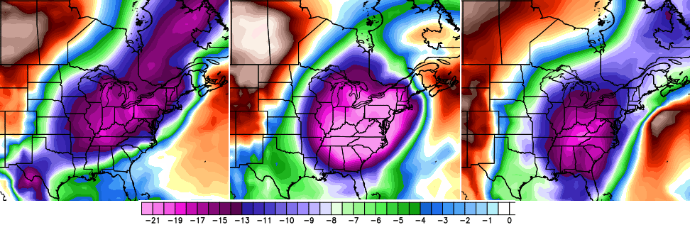 Let’s hope that’s not correct!
I will have updates later today. Make it a good one and take care.

Each blast will last one day and be accompanied with nuisance flurries and a dusting. Just keep recycling the same forecast every few days. Just remember this most depressing of Winters is drawing closer to ending every day.
Thank GOD for that.
The shorter this winter ends up being, the better. It’s been a disaster and a half for snow lovers. I’m thinking about moving to Alaska. Except there’s like, ten times more snow there than here.
Oh well.
At least coming into the site almost 5 days now without a visit, I can surely tell the weather wants to change. Or is it going to be a total rear end about it and decide now it wants to do something? Are we going to be teased again? I will never fall for it.
First
Ok tied for first.
Eighth
I guess thinking we had nowhere to go but up for snow was a tad presumptuous. Last year we hit 10″ south of the river (some not half of that) and this winter so far 2.5″ (some virtually none).
Since that is still not technically zero, I shall refrain from saying we have nowhere to go but up this time. That said, this has been the wimpiest winter I can recall when considering snow and cold together.
Sadly Bubba, I have a terrible feeling that the next winter will only result in less snow than this one. One word can describe this phenomenon….. trends. I’ll believe the trend over any model any day.
If you think you can get back to back winters with less than 2.5″ you can think again. Then again, I guess no snow and driving on it = winning! Hahahaaha….
The models should be using the trends to correlate. It is part of a fancy and often underused thing called regression. Seems a lot of fire and forget modeling and will continue until there is accountability. Yeah right 😉
This will be interesting… “a company called Spire announced its plans to deploy 20 tiny satellites into low-Earth orbit. It hopes to generate a private database of global weather data, which it believes will rapidly become the world’s largest.”
“This satellite data system will provide five times more [weather] data than the world has today by the end of 2015,” it says in a release.”
Wow, they also said they would be able to get more accurate data of storms offshore instead of the sparse buoys or waiting for the US grids to sample the storm. So more accurate current data put into the models should generally increase weather forecast accuracies, at least in theory. I really hope this is successful and we’ll have MUCH more sampled data to view, and use.
Link to the article here and a link to their website here.
That will be interesting, but then we will just have drab winters with no hope whatsoever.
Is the software for those sats ManBearPig approved?? 🙂 😉
That’s impressive. More new/albeit expensive equipment to tell us here, rain followed by backside flurries and two days of cold. Then we do it over again.
Complete overcast this morning.. I was looking forward to another sunny day.
I’m over this snowless winter. Just bring spring. 🙂
its only 22 more days people until March