Good Sunday evening, gang. I wanted to drop by for a quick update on the increasing threat for arctic cold to engulf the bluegrass state later this coming week. This is some ugly cold coming to much of the eastern half of the country and it has the look of locking in for a while.
The first arctic front arrives Wednesday night into Thursday. This will have a band of light snow behind the front with northwesterly wind flow snow showers and flurries trying to put down some light accumulations…
Check out the temperature progression…
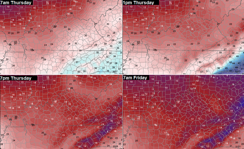
Wind chill readings by that time could be around zero.
Another arctic front sweeps in on Saturday and could produce a shot of some light snow for all the lovers out there. The air coming in behind this is even colder…
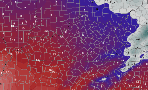
There’s a chance of pushing zero for actual low temperatures behind that second arctic front. Gusty winds could produce wind chills similar to what we went through back in early January. Yes, this has the potential to be that cold.
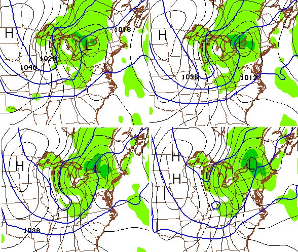
As hard as it is to believe, that’s just the start of things. The setup beyond that is one that will be primed for a couple of big winter storms across the Midwest and Ohio Valley. Can we actually get one of those to smack Kentucky around? Since I’m now in spring mode, that would be my luck. 😉
Additional arctic blasts also look to continue. Yippee.
See you guys back here for the late night update. Enjoy the evening and take care.

Thanks Chris! I appreciate and look forward to your updates, even the ones in the middle of the night, lol!
Rodger has seen big snows in Kentucky as late as March 20th so who knows what’s yet to come. Most of snow lovers would probably consider this to be “good” winter if we could get just ONE big thumper. But Rodger won’t be holding his breath.
I won’t hold my breath either. Here’s hoping for a thumper or two or three . . . 🙂
Aw right! Aw Right!
I think we have rubbed off on you Chris. lol Last month and December I wanted a big snow so badly I couldn’t stand it, but now I really couldn’t care less. The thrill and anticipation of snow has completely left me and warm weather is what I’m craving now. I really hope these cold snaps don’t last into March.
March 2008 blizzard gave us 15″ or so in Boone County (Northern KY), and there was the March 93′ super storm…. Also don’t forget that huge April 87′ snowstorm. March and April can be fun on the rare occasion. 😉
clipper season has begun
This hasn’t been a typical clipper season either. Even they blow up enough warm air to rain themselves out and end as flurries.
What rain? We’ve hardly had any of that either
The best thing about arctic cold is that it keeps the casuals off the trails at Indian Fort. Sooooo quiet and serene to go along with a nice (snowy?) view.
Braver than I CB, after staying up to watch Metallica perform for the debut of the hard rock/metal Grammy and lose to Jethro Tull, I can’t risk any more live Grammy watching in this lifetime.
BAILEY come back from the DARK SIDE!!!!! u spring lover u.lol for some reason I think KARMA will bite Chris SPRING Bailey in the rear before WINTER OVER!!!
He has gone over Rolo…or he is pretending to have gone over as a snow-tempting strategy 😉 I am still dedicated to snow!