Good Monday, everyone. Colder air is pushing across the commonwealth of Kentucky today and this is just a small preview of what’s ahead. We have some big time cold on the way for later this week into the coming weekend, and that’s likely kicking off a nasty period of winter weather.
Colder winds continue to blow out there today. Temps will pretty much fall for much of the day and will drop into the low and mid 30s this afternoon. A few rain showers will be possible early with some snow showers or flurries possible later today in the central and east.
The main show begins to push in Wednesday night as arctic air attacks. This is a significant blast of cold air that may have a band of light snow and flurries along the front. The northwesterly flow behind has the look of a decent snow shower and snow squall maker for Thursday…
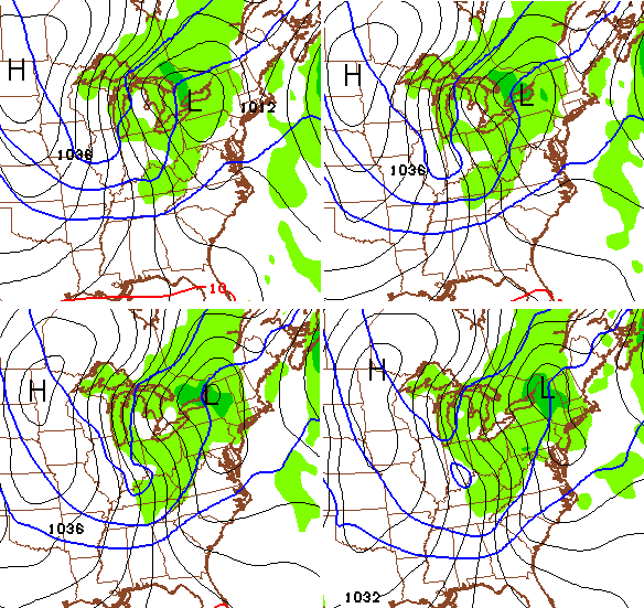
Folks, that is -20c air at 850mb rolling into our region and that will combine with our northwesterly wind coming off the Great Lakes to kick off some squalls. Those could cause some issues if they develop as indicated above.
Gusty winds and falling temperatures would be with us on Thursday with readings dropping into the teens. Lows by Friday morning may reach the single digits and low teens with wind chills around zero or a bit below.
The next arctic front shows up on Valentines Day and looks even stronger and colder…
That could also produce some decent snow showers and snow squalls around here late Saturday into early Sunday. The air behind that is stupid cold at 850mb and is greater than -30c just to our northeast…

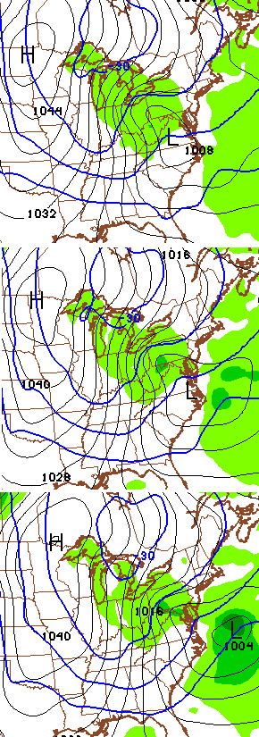
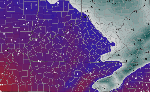
The computer model forecast numbers keep tending colder with all these shots. The shot above looks like this for Sunday morning lows…
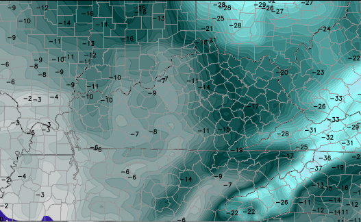
The wind chills on this latest GFS for Sunday morning…
Again… that’s some stupid cold across the eastern half of the country.
This is also a pattern that can create a major winter storm for the Midwest and Ohio Valley next week. I’m not saying what that specifically means, if anything, for our weather in Kentucky. Read that last sentence again and make sure it sticks with you. 😉 I’m simply stating the look of the overall pattern is one that can produce a significant winter storm from the Midwest into the Ohio Valley.
I will update things later today. Take care.

“stupid cold” definitely applies to those model temps for WV. I really hope those don’t manifest when the time comes.
Morning sunrise today provided by Lake Matheson in New Zealand.
http://i.imgur.com/QmDK5IY.jpg
Morning music provided by Julie Fowlis covering Blackbird by The Beatles in Scottish Gaelic.
http://youtu.be/0MzetQfKwbE
No matter how many disclaimers you post, I am sure that somebody will say you are hyping this up. Sad, really. 🙁
No doubt had some of the outlooks of the models panned out, CB would be more descriptive with snow chances. Seems a wise move by CB.
This is easily the least amount of times by a long shot for CB to not mention winter snow threats from systems or pull the trigger for a winter since i have been following the blog. This includes the earlier days with TG Shuk.
Yea, verily. 😉
Chris is saying it will be below 0 and we will have a snow storm next week! Just kidding 🙂 Models are not forecasts – models are often wrong. …from a week or more out – usually wrong… or just so loose at a distant that they are pointless…almost.
Haha Chris’ posts have more disclaimers at the end than a Viagra commercial
Well, if lack of snow equates to impotence, this region needs a truckload of em’! 😉 🙂
Local mets in Cincy already calling for snow next Tuesday. This far out, it surely means rain.
A nasty period of winter weather. Hhhmmmm has to snow for it to get nasty. I do not consider cold and dry nasty. Mother Nature is nasty for sending the cold without precip.
Thanks for the update CB. Hope everyone minds your disclaimer.
I have already told all my social media friends that we will get more snow the remainder of winter than we average in a entire season.
Think Snow!
Freezing rain and ice are nasty as well. Seems this far out that would be a concern.
Yep, not seeing “snow” as a key topic and for good reason so far. Not looking good for snow lovers this winter, but even though snow lovers are turning to haters to areas to our north and north east. They are about to get smack hard again, for the fourth time with over a foot. That is snow on top of ice and snow layers.
Seems funny that snow has been so wimpy some of our local news/mets seem compelled to tweet and report about other people’s snow.
Again, if the option was what has been hitting the north and NE, our weather seems the better option. Even with the salt piles building up on roads (that is what those white piles on the roads and sides are). So much salt, so very little snow.
Well guys the only thing we can do is take one day at a time and not lose any sleep over weather we get snow or not. Lol!!!
Hard to get that cold without snow on the ground.
Verrrry interesting! Sometimes you get what you want. Valentina’s Day is a good time to expect something, even snow. After we get some good snow (2-3 of them) then spring can arrive. We are due. It is OUR turn.
I’ve been reading about the Bengals all ready for next year. On computer models it looks like they are going to win some playoff games……you know where I’m going..I highly doubt they win the big games, highly doubt it will snow big the remainder of winter.
I actually haven’t been reading about them, to be honest it’s not fun anymore, not a chance until upper mgmt changes…same as winter weather for snow..not going to change
I’m still a fan of both, can’t help it. But I’m realistic!
Rodger follows a met in Evansville who is very cautious with long-range southwest systems. He says: “Models are cold and suppressed a week out and then torch and north a few days away.” Rodger thinks he’s right!
think, ,, should say knows he’s right