Good afternoon, guys and gals. Temps continue to take a big tumble from northwest to southeast. The numbers are dropping by more than 20 degrees and will put everyone in the low and mid 30s by very late this afternoon. We could see some flurries or snow showers trying to pop, too.
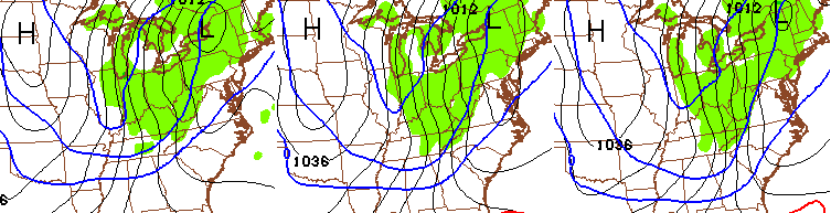
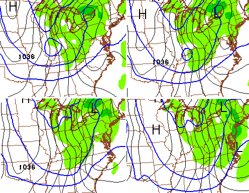
This is nothing compared to what’s coming in a few days as arctic air is set to blast the bluegrass state. The first arctic front arrives Wednesday night and will unleash a nasty northwesterly wind flow that should create widespread snow showers and snow squalls. The models have some nasty written on them for Thursday…
NAM
GFS
Temps dropping into the upper teens, wind gusts of 30mph, wind chills near 0 and snow squalls could combine to cause some issues on Thursday.
Temps by Friday night will drop into the upper single digits and low teens.
The next arctic front arrives on Valentines Day and will bring even colder air our way. The numbers may wind up 30 to 40 degrees below normal across our part of the world…
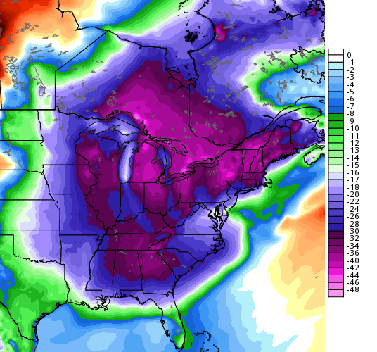
Got dinner plans for Saturday Evening? Check out the 7pm numbers from the GFS…
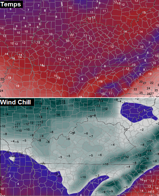
That is likely to be accompanied by snow showers and snow squalls. Temps by Sunday morning will drop close to zero in some areas with wind chills even colder than what you see above.
The pattern remains ripe for some big ticket winter events through the middle of the month, at least.
Another update comes your way this evening. Take care.

Thanks CB!
I miss the “old” CB though that felt comfortable to talk about snow in outlooks. Darn model confidence now must be similar to lottery chances, so understand none the less.
Heh, I wish it worked that way. Every miss would mean the next system would be even bigger. Then after several misses in a row we’d get 450million inches of snow. Wait, okay, maybe not then.
I agree! I wish he would go back to that as well.. How much snow we looking at for Thursday? Timing going to make the morning commute rough?
Come on CB!!
This really stinks.. I was hoping we wouldn’t have to deal with that type of cold again this late in the winter. Frozen pipe weather! Yay!
just for funzies here is accuweather on London weather for the rest of the month – how many times do you see the word snow on there ? zero, zilch, nada
http://www.accuweather.com/en/us/london-ky/40741/month/17676_pc?view=table
Almost as many times as you should get your forecast from Accuweather
Through the middle of the month? You mean in a week? That is not much at all. The overuse of the word nasty makes no sense to me. Why is it never nasty in July? Emotional weather belief system disorder. We all suffer from it. From the bring springers to the ice fearers to the humidity lovers, reading this blog is as interestingly eye opening about human nature as much as it is about mother nature. All that being said, I love spring, summer, fall, AND winter, and I don’t really rush the end of any of them. I just don’t get the constant future thinking mentality, especially in a time when now casting trumps forecasting. Anyway, I for one hope it is frozen through the month, like record low temps style, and them I will look forward to spring and whatever misery the storm season has to offer us. 🙂
I think he meant to put the *end* of the month since that’s what he’s said on his past several posts.
Snow or no snow. Temps bottoming out in the low single digits and wind chills below zero is pretty nasty cold for mid-February. Unheard of? No, nasty yes that qualifies. The word brutal would also qualify to describe the nastiness of single degree temps and wind chills way below zero.
I agree about the word Nasty…(that would tell me its got everything..for winter it would mean Cold, snow, wind..for spring it would mean wind, rain, lightning, etc..
So if were just looking at cold I would use the word Brutally.
But Chris used nasty with wind/cold/widespread snow showers and snow squalls.
I see no issues with CB using the term “nasty” like he does.
Two things:
One: l luv fall because it is the best weather to snuggle 🙂
Two: How can you quantify the subjective term “nasty” to one set premise or level? One man’s nasty stuff doth not equal another’s. 🙂
That’s my point.
Wind chills near zero with snow squalls and 30mph winds are nasty. If you don’t like how I say things… don’t read.
Even though some of you complain about everything… I still gots the love for ya
Seems like nasty stuff to me 🙂
Man, I got the don’t read for that? Just discussing something I find interesting. Zero disrespect meant. I see I am in the minority. I’ll move on.
Here’s ya ticket
Well, my emoji’s didn’t show up! Had a little wittle ticket for your ride on the itty bitty pity train express.
I’ve just put in an order for a propane refill.$$$….Hate it for the animals. Thanks for the updates, CB!
Maybe the Weather Channel will call that system “Janet”.
Nasty Stuff! 🙂
That’s Miss Jackson if it’s nasty.
Not so accuweather is showing a warmup around the 20th. That may be why CB wasn’t saying cold to the end of the month. They are showing the rest of the month staying average or above after that. Pretty much the way weather works. Give us 10 days of cold and then 10 days of warmer days to get us closer to normal.
Dude we are not getting another substantial warm up like the one we just had. By the end of the month we will be well below normal for the whole state. Just because it has been warm recently that means nothing.
I am NOT greedy by nature..
just bring me an over performing clipper.
is it going to be real cold I want to see some white
Before we get excited about snow chances for a big snow next week.
The top analog used by the climate prediction
Center from Feb 17-23 is 1991. That was a very
snowless year. Looks to get cold but not buying any
significant snow as long as 1991 is still a top 3
analog. Still hoping we finish this year with a March 1993
event.
Awwww. The wondrous blizzard of 93′.
Forget what’s coming, it’s friggin’ NASTY outside right now!
Give me a dry, potentially frost-biting cold over this any day.
Outside right now is that fishin’ below Wolf Creek Dam before dawn, moisture creepin’ into yah bones, wakin’ up after a night of yah covers bein’ hogged away, the temp of your ex’s heart, kinda cold.
Accuweather saying warm up by the end of the month? How could they possibly, POSSIBLY know this with the models being the way they have been? I mean, it’s Feb 9th! I think they nor any other met has a clue what the weather will be like by the end of this month. I mean, look at the way the models have been all winter……
The stuff on there is mindless model drivel.
Thx for all your hard work CB!
Greatly -greatly Appreciated!
As for me – I’ll gladly take the cold over spring time when I have to
“Dig” my eyes out due to the choking pollen in the air; and then the
Smothering humidity and heat of summer
🙂
Nah give me the freezing temps any day!