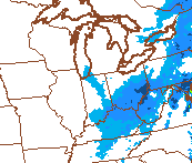
Good Monday evening, gang. Areas of freezing drizzle and snizzle continue to push across central and eastern Kentucky. That could cause some slick spots on bridges and overpasses, so keep that in mind if you’re traveling tonight.
The bigger story continues to be on the harsh winter weather ahead of us. The next 2-3 weeks have the potential to be downright nasty across our part of the world. The nasty stuff starts on Thursday as arctic air surges in and brings 30mph winds, wind chills nearing 0 and snow showers and snow squalls. Those squalls will likely cause travel issues through the day.
Check out the simulated radar from the NAM for Thursday afternoon…
The next blast of arctic air will be even colder as it sweeps in on Valentines Day. Snow showers and squalls should accompany this next system as temps drop to around 10 degrees by Saturday evening with wind chills even lower. Check out the numbers from the GFS…
 Readings may be near 0 in some spots by Sunday morning with wind chills around -10. Wow.
I’ve been talking about next week having the potential to produce winter storms from the Midwest into the Ohio Valley. The European Model is starting to pick up on that possibility…
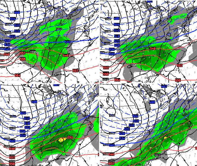
 We will have to wait and see how things turn out, but the pattern is ripe. I guess we should go ahead and say congrats, Chicago. 😉
Have a great evening and take care.

Just a thought but if the storm is postioned that far north this early, would it not trend further north over time and be rain in Kentucky. Seems like that’s been the trend so far this winter.
Not where we want the models to be right now, have fun with that snow Canada lol
If it happens, it’ll be a surprise storm that no model will see until about 24-36 hrs prior.
Thank Spring ⚡️☔️⚡️
Or think spring, it’s up to you…. Oh boy
The next week storm will never verify unless it is a strung out weak storm and or the 1st storm this weekend helps establish a short term east based -NAO. This will need to be a thread the needle winter storm for us as the only things in our favor is a strong +PNA and the MJO. The overall pattern has not changed… very likely that it goes North of us and we get rain after a brutal cold stretch
Chris, is there anything that we have going for us that would argue for next week’s system to stay around our neck of the woods instead of trending north? Just wondered if there wasn’t anything about the pattern this time that’s different than the past several chances.
was*
Im just going to continue doing my Spring Dance in hopes that it continues warding off Winter weather.
http://youtu.be/2KPwzGzk2S0
I’m not even gonna comment on that fantasy snow map, but wow….those temp maps look brutal and unfortunately, they may be right. YUK!!!
Cold cruel torture no Matter how many disclaimers they put out saying this is only what the models show. We all know how reliable the models have been this year, absolutely unreliable. But I keep remembering my Granddad telling me about the blind squirrel and the acorn. Like I said, cold cruel torture. 😉
Love the Chicago comment, Chris. Looks like you have joined the rest of us in the model skeptics club.
We need the system to show in southern Tennessee/Georgia at this point to trend to us…… Maybe the Gulf…..
I luiv s rainy nite!!!eddie rabbit!!!
Anyone in he Somerset area know if it’s drizzling/snowing right now. I know it’s drizzling where I live but not showing up on the radar.
Next week is crucial if we are going to get a big snow this year. Some models are indicating warmer temps coming in the last week of February. Time is winding down and we need to take advantage of the final shots of cold of the season.
BubbaG tell Lucy to deflate the football before getting it out.
Hopefully the GFS comes back around showing a big ole ice storm with heavy snow on top around the 17th..Winter goes out with a BOOM..
Let’s say the models do have it correct right now. Below freezing temps for several days with a southern storm over riding the cold.
ice ice baby…..
Love the look of that Euro map. I have said that six times this season. If the Euro snow map panned out a week out all season Louisville would have over 40 inches of snow.
What day is the snow total map for?
Euro to the north..GFS to the south..Right where we want to be..
A little deck duster in Frankfort tonight, those folks up north have had enough, come on snow gods give us some snow this time, we are so over due for more than an ankel nipper!