Good Tuesday, folks. Old Man Winter is loading up and is ready to send arctic air to attack the bluegrass state and much of the eastern half of the nation. Bitterly cold air is on the way and will come at us in waves through the weekend. Each wave will likely be introduced by snow showers and squalls.
The first arctic front arrives Wednesday night into Thursday morning. A period of snow showers will be likely just behind the front, but snow showers and squalls will kick it up a notch during the afternoon. That’s when a STRONG northwesterly wind kicks in and sends flakes all the way into the south…
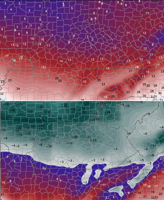
Throw in 30mph wind gusts, temps in the upper teens and low 20s, wind chills around 0, and you have an all around nasty day. Light accumulations will likely cause some travel issues.
Lows by Friday morning will hit the upper single digits to low teens.
The next arctic system dives in on Valentines Day and this system has a wow factor to it…
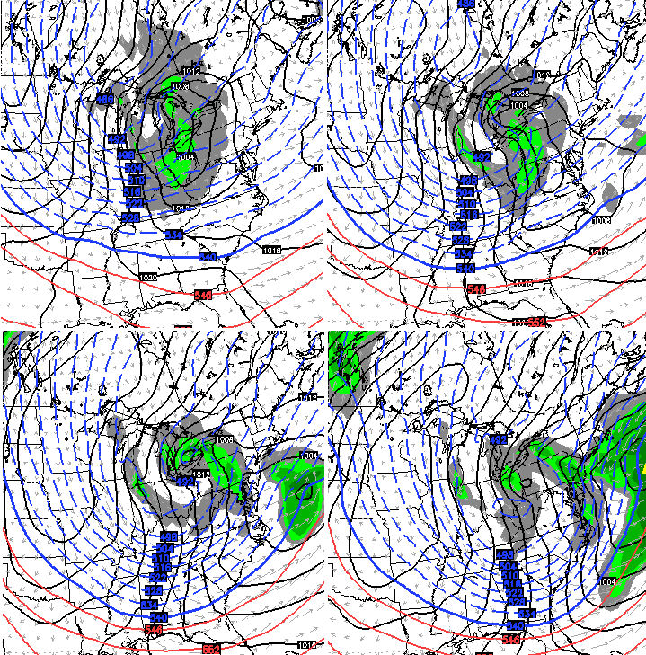
That is one DEEP system that will bring arctic snow showers and squalls. One could argue this is the Polar Vortex dropping all the way into our region. Winds will be crazy gusty as temps absolutely tank during the afternoon and evening. Check out the temps and wind chill numbers for 7pm Saturday evening…
That is just absolutely ugly for those who have Valentines Day dinner plans. Let me suggest flannel or some long johns as a gift to your significant other. 🙂
Lows Sunday morning may drop to around zero with wind chills from -5 to -15. Highs may struggle to reach 15 degrees in some areas.
The pattern for next week is one to keep a close eye on. The setup should yield a winter storm developing across the Midwest into the Ohio Valley. Again, I have no idea on what that means for our weather at this point. All I’m doing is targeting a timeframe for a storm system to develop. Watch next week!
I will have updates later today. Take care.

Cool! So a snow storm for KY next week? (Just kidding)
Sounds like it’s going to be a good time to snuggle with your Valintine !
Thanks Chris for the info that you provide for us . Everyone be safe!
Oh come on Chris. We have been waiting for next week all winter long.
I respectfully wish our man CB did not use the term Polar Vortex, but really like the approach and tact of CBs outlook. If we base the models on the previous runs for at least this winter, the placement of the system needs to be way south of Kentucky to have a chance of actually hitting Kentucky. Since over kentucky now, looks like some backs up north and NE of use are going to be cursing snow after next week. They keep getting slammed.
Kentucky (sorry for no cap for our fair state)
us
Whatever
Solid ice and freezing drizzle here in my part of Knott County this morning.
PLEASE Mother Nature let us have something to track and impact Kentucky next week!!!!!
Nope. You will will have to earn everyday the hard way 😉
That’s definitely the message she’s been sending all winter for sure!
Need to get this done next week. Winter is winding down and warmer temps on the way. It may be our last shot of significant cold air this winter.
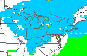
On a side note NWS calling for a coating up to an inch for Thursday for SEKY. Typical forecast for this winter. More than likely will end up a coating.
It doesn’t need to be THAT cold, just cold enough that it can’t rain for a couple weeks in Berea. Our ground has to have some time to get down from 99.9% saturation before the rains come in the spring. It temporarily froze a little a couple times, but it’s been a swamp for the entirety of Jan.
Snow dusting in Clay…got a snow day!
next week. cant wait! looking forward to our rain to dusting to rain again 🙂
uhh nobody mention the snow etc we got last nite. yea few flurries was mention but not slick roads.yea after the fact many forcasted it.
Alright weather guru’s, what are the chances of a snow day Thursday around ashland, Ky??
63.87968548%
Yeap it be cold rain next week local weatherman saying high 30s Monday and Tues.
Not sure why we don’t have an idea about what impact will be next week, it maybe will look good at some point, BUT you know the drill….
If we template to the other systems, we are too south if the system outlooks a hit to Kentucky at this point. All have gone waaay north. Perhaps a model solution showing the Gulf being the main spot right now would get er’ done ‘)
At least Tennessee/Georgia border.
😉
A snow on Thursday for the Ashland area does not look too promising right now. Stranger things have happened, though. Driving home one night in a 3 inch snow I heard a radio announcer say we had a 20 per cent chance of snow. No one had told him it had already happened and was still accumulating. You just never know. I hope it does snow on Thursday.
Just our luck Eastern Ky gets clobbered on the latest run of the GFS..Guess that means Boston will get another 2 feet of snow..Maybe this is one time the models will be right..NOT…
Would you please post the GFS? Thank you!
Yeah the 12z GFS says to KY be careful what you wish for let’s have a statewide snowstorm next Tuesday. The gulf wide open and ready to help out in any way with plenty of moisture to work with.
Anybody heard of 35 degree rain then backside flurries?
That’s an interesting hypothesis you’ve introduced. If only we hand a decade or so to study it. 🙂
had*
Remember the last time the models had it an all snow event it ended up being an all rain event