Good afternoon, all. My time is limited so let’s get right into it. I have no changes on the arctic blasts coming in over the next several days.
The first arrives Wednesday night and Thursday with gusty winds, snow squalls, falling temps and wind chills near 0. Some travel issues are possible across central and eastern Kentucky.
I’m now seeing the potential for some light snow developing late Friday into Friday night.
The nest arctic front slams in here Saturday and is much stronger than the first. Snow showers and squalls will be noted as temps absolutely tank. Gusty winds will create dangerously cold wind chills. Check out the 7pm Saturday temps and wind chills…
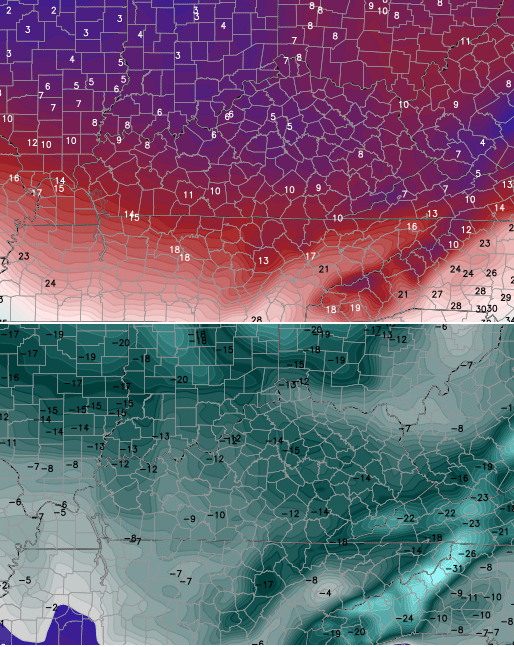
Those numbers get even colder Saturday night into Sunday morning. Again… those kinds of numbers are in the danger category!
That takes us into early next week. The models are all now picking up on the winter storm potential I’ve been talking about from the Midwest into the Ohio Valley. Let me be clear… I have no idea what this means for the weather across Kentucky.
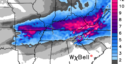
The GFS likes a snow track for us…
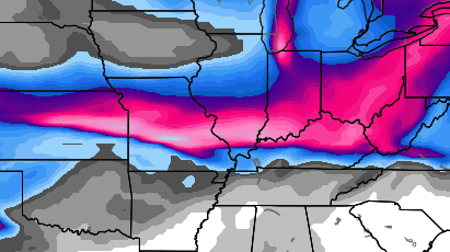
The Canadian Model…
Those are just model runs and should be not taken at face value from this far out. It is interesting to see both showing a similar overall look. Both also unleash even colder air behind any potential system…
GFS Temps and Wind Chill
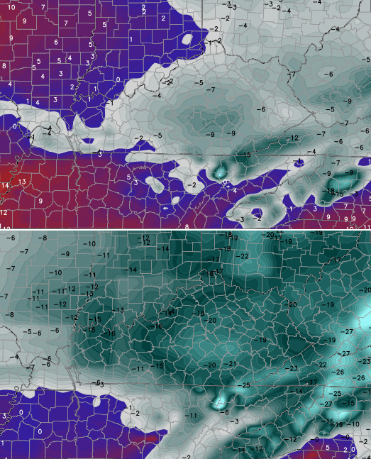
Canadian Model temps

As I have mentioned… the next 2-3 weeks can be flat out harsh around here and much of the region.
I will have the latest on WKYT-TV starting at 4 and will update things again later today. Take care.

appreciate the models chris, thanks
Those model runs I think would bode well for places like Chicago, Toledo, and Cleveland to get in on the southern edge of the snow shield…
I kid…I kid…
In truth I am thankful for your updates, Mr. Bailey. Will be watching this one closely.
Seems to be reasonable and accurate. Every system showing KY in the sweet spot days or week out has been way off and far too south. Even CB has given up outlooking where it might hit.
Well, thanks for the cold update, but can anyone shed some light on this situation and suggest any reason why we shouldn’t expect to see the north and west shift on the snow side of this storm? Frozen ground, then lots of rain…more icing problems…tired of snow days for black ice. Have a great day!
I don’t like cold with any hint of precipitation around Washington Day.I remember a severe ice event that crippled Scioto County a few years back. It was good for the hospital nine months later though.
Should we take the cold for face value this far out? If so why is it so much more accurate?
Wish that was the models for tomorrow. Since I’ve been following this blog, I’ve never seen a system that had us in the sweet spot hold up a week away. Not even saw one three days out get it right. The only way these things never move is if they are just south of us, and then we don’t get the infamous nw shift.
So true, Bob…so true.
Look out, SEKY! Sure looks like your snow could be on the way! Hope we all get a good snow sometime soon.
depends on which model you worship and if you bolieve 😉
I’m a boliever
It’s better than being a rosebud lol
As far snow goes believe it when I see fit.
Thanks for showing the models, Chris. Your interpretation of the models would be interesting to read, too. I wish you felt like you could give us that interpretation as you used to do.
Well, maybe things will get better in the spring, but for now the forecast models and CB are pretty much this…
http://youtu.be/cAaLhzRSzac
I see this as being a freezing rain event around the Louisville Metro area. Cold air at ground level with warm air coming from the south.
With a frozen surface in place and cold air, waa would be a mega bummer. Hopefully it goes way north in that case. Way north.
Well if the models are showing snow and cold this far out, it will probably be swimsuit weather.lol
Its something to track it’s a southern fed system cold air will be in place gulf moisture looks available all in all that’s pretty encouraging.
Given all this, the models are wanting to dance got nothing to lose, I’ll play along lets dance.
These models really look good for Chicago, Detroit and Cleveland.
Hard to refute this winter so far.
I’m hoping for a more suppressed solution in future model runs considering the strong northwest flow developing over the next week. Otherwise, its more feasting for folks to our north, while we see festive flurry flakes.
I love your honesty.
“no clue what this mess means”
I’ve given up on winter.
Well, looks like winter might try to tease us one more time with the models, but no matter what happens march is getting close and I will be ready for spring.
At least it would appear that cold air will be in place for anything that develops next week… that being said our “cold” air this year has been pushed around quite easily! Let the waiting game begin!!!
Here’s the Euro..Could be nasty if you like ice..
http://i.imgur.com/h20ifma.jpg
If it is that brutally cold both before and after the next system winter can freakin drop dead. I will absolutely lose it of the only time we rise above freezing is when the precip shield is over us. DONE WITH WINTER!!!!
Cold air has been pushed out very easily this season. Hope winter has one last cold punch that wins out this time. Still have 1600lbs of salt to throw.
Like the looks of the snow maps. Nice eye candy. LMAO like that will really happen.
Please let it snow!!
Anyone that busy into those models, I have ocean front property in Utah for sale. Looks like a lake cutter to me.
Bring on spring, unless you guys like junk models, cold and gray weather.
A lake cutter???? How and where do you see lake cutter on this?
Let the shift begin… Watch out Chicago!
Lol at -25 wind chill in southeast ky.. Surely that’s Not gonna happen.
Grrrr.Now you see me now you dont.Low went right over Ky AGAIN.Apps hate models.GFS bad..
At least it’s the first signifcant week out storm of the season. This used to be a weekly thing the last few winter. A lot less heart breaks this winter. History is not on our side with “week away” storms.
There have been a few before this actually and why CB is non commit this far out. They keep showing Kentucky a week out and then shift way north a few days out.
Did you mean to have a wink icon? 😉