Good evening, gang. I’m dropping by for some quick thoughts on the pattern ahead, but I don’t really have anything new to add. Let’s get at it…
– The first arctic front arrives Wednesday night with a band of light snow behind it. Snow showers and squalls will then quickly develop on a strong northwesterly wind flow. Light accumulations may cause slick travel.
– Temps drop into the upper teens and low 20s on Thursday. Gusty winds will make it feel closer to zero at times.
– Friday is frigid with high single digits and low teens to start with wind chills around zero. Some late day snowflakes will be possible ahead of the next arctic surge.
– This surge moves in quickly on Valentines Day and will bring even colder weather. Temps will drop into the single digits by Saturday evening with wind chills going well below zero. Lows by Sunday morning should be in the 0 to 5 above range for some. Dangerously cold wind chills may reach -10 to -15 at times.
– Some snow showers and flurries will also be a good bet as this round of cold comes in on Saturday.
– A northwesterly flow could cause a period of light snow to develop at any point on Sunday as the bitter cold continues.
– The setup for early next week continues to advertise a possible winter storm from the Midwest through the Ohio Valley. That’s a week away and I’m not going to pretend to know what impact, if any, that would have on our weather here in Kentucky. I posted snow maps from the GFS and Canadian models earlier today and both were favorable for snow in our region. The European Model shows a similar result…
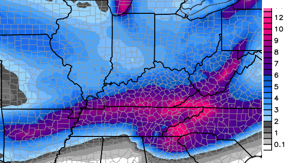 Again, that’s a week from now so take these maps with a grain of salt. It is good that the models are now showing a storm system that I started talking about days ago. It still doesn’t mean the storm is even real, but it’s a good sign there will be something for us to track.
The big difference I’m seeing with this potential storm and the others this winter… we have arctic air ahead of it and arctic air coming in behind it. We haven’t had either of those two with any of the other storm systems this winter and now we have both. We will keep an eye on it.
Enjoy your evening and take care.

Thanks Chris! No rest for the weary! Appreciate all you do. Now, enjoy the rest of the game! ;). GO BIG BLUE!
Thanks Chris, Go Cats!
I like the possibilities! Good to see Trey back. Go CATS!
The odds may finally be in our favor. Looking forward to a hopefully fun weekend of winter weather tracking. 🙂
Nice post! If anyone accuses of hype they are Agendites.
Go away, big meanie troll! 😉 😛
http://i.imgur.com/Ppgleoh.jpg
So i might be able to dust off my snowshoes?! Stoked! I remain “skeptically hopeful” that there will actually be real snow accumulation on my lawn. I will be watching your posts, CB, very closely…….
Arctic air in front and arctic air behind means dry in between.
Yep, but still better than ice:)
Get ready for the North trend as some of the late afternoon models are already moving that way with mix or rain for most of us. With no blocking, positive NAO and AO any strengthening storm will cut right into the heart of the cold and thru Ohio on its way to the lakes (that would be hard to watch). We better hope this storm remains weak and or the cold high pressure is strong to force it South.
As always, professional. Hopeful for THURSDAY snow day and maybe next week…Somerset needs snow!!!!!!
The weather this week will be nowhere near as Nasty as Willie Cauley Stein and Karl Anthony Towns.
It is good that the models are now showing a storm system that I started talking about days ago.
LOL! Model porn! anybody believing 8+ inch snows from Northern Georgia to SE Kentucky please balance on your head until next Thursday 🙂 Nice to look at though !