Good Wednesday, everyone. We have some nasty winter weather rolling our way in the coming days and this is likely the beginning of a harsh period. Arctic cold, dangerous wind chills and increasing snow chances highlight the pattern I’m talking about.
The first front arrives this evening into tonight. Out ahead of it, temps will spike into the 40s with a mix of sun and clouds with winds picking up. Those winds will really increase overnight into Thursday as much colder air swings in. Readings drop into the upper teens and low 20s with single digit wind chills early Thursday.
Snow showers and snow squalls will be common across central and eastern Kentucky and those could cause some travel issues.
 With gusty winds, any snow that’s out there will be blowing around.
Temps by Friday morning will range from the high single digits to the low teens. Wind chills may dip into the negative range for a time.
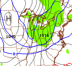
The next arctic front slams in here on Valentines Day and the GFS is now much more enthusiastic with widespread snows…

With such cold air, things could be pretty darn snowy across the entire region. Gusty winds would again blow around whatever snow does fall. Temps crash all day long on Saturday with wind chills going below zero from late Saturday into Sunday.
Actual low temps may flirt with zero…
Those numbers are from the Canadian Model and I’m showing them because that model has performed very well with prior cold blasts.
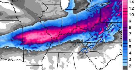
This leads us into early next week and into the timeframe I’ve been highlighting for a possible winter storm developing from the Midwest into the Ohio Valley. The models continue to point in that direction, but will change a bit from run to run. The most important thing to look at from this far out is that the models are still showing some kind of winter storm.
GFS
Canadian

Once again, the impact, if any, on our weather is a long way from being known. That said, the pattern does look ripe for some kind of winter storm to develop early next week. That would then be followed by additional shots of arctic cold.
This is a wicked looking pattern shaping up for much of the country over the next 2-3 weeks.
I will have updates later today. Take care.

Possible snow day in Fayette tomorrow??
I was just wondering the same thing. Guess it depends on how early and exactly where the snow showers set up.
I give Fayette a 10% chance of being out, with a 30% chance of delay.
Well that makes me very sad lol
I like that one model is a tad north with the heaviest band and the other is slightly south. One up the Ohio River and the other along the KY/TN border…that seems perfect at this point for Lex metro and surrounding county snow fans
Thanks for the update Chris. Going to stay optimistic and say all of Ky will get into the fun and games over the weekend and next week. if the cold air can dig to Florida over the weekend then we have a better shot of snow or Ice if the low strenghens. If it stays weak we could miss the snow to the south. Now wouldn’t that be a slap in the face.
Think Snow!
It will be nice to hopefully get more than a dusting. Huntington hadn’t even managed the dusting that a few others received. It looks like the GFS has began its movement North for next week storm.
Northward movement has already begun for the storm next week. This will end up being another Chicago snowstorm while KY gets rain and 50 degrees. Book it.
the most important thing on the model isn’t the storm but the north trend,as usual
It appears to already be doing that. The model average yesterday was right over Kentucky and now more north. Exact same trend as the previous events. Scary exact and ties into the models overstate outlooks.
Just a few days to find out. Looks like lots of cold and very little snow.
Yepper. By the weekend model runs the storm will be in Canada or at the very least, in the far north. We all know by now that is going to be the outcome. 😉
With nothing stopping it from going north this will go north
I guess there is an adjective worse than wicked and that would be evil. One worse than nasty? I don’t know. Sick? Rotten? So, if the temps are worse than predicted what should it be called? As for snow, I do hope our chances are pretty good. Anyone remember Johnny Mathis?
If little to no snow = Bad nasty
If with snow = Good nasty
If with ice = Nasty stuff
Not gonna happen gang, all the models are trending north once again. I said yesterday that this will be the infamous lake cutter, and I stand by this.
Again, with the models being at epic bad, why even bother posting them? The chance that it even remotely verifies is 10%.
And, I notice that Chris is backing off on the wicked snow squalls and showers for thursday.
Nothing has changed in his last 3 updates for Thursday all said temps teens to 20s and windchill in the single digits
Yep, CB notes the squalls. Seems no change and CB has pointed out the model outlooks are essentially not something to bank on.
I guess it could happen, but I have a hard time agreeing on the lakes cutter scenario, given temperatures are going to be near zero just a day or two beforehand?
I’m more worried about Ice than anything.
As CB pointed out, the difference should be cold air already in place for next week. This should help suppress the flow to a less northerly direction. In other words, Tennessee will get hit! 😉 🙂
That would put me closer to the action IF that was the case
At least the European is already moving next week’s heavy snow to our north. That way we won’t get depressed by a late shift to the north. It’s ruining our chances before we even have a chance to get upset.
People were upset last night when some of the models started shifting lol
Am a little worried about those gusty winds and wicked, nasty cold temps. Sometimes that can spell trouble for power lines out here in the country with so many tree limbs falling. Just some snow please. Do not want nasty, wicked cold and winds.
Sorry if it’s just strong cold winds, i usually wouldn’t use the word “nasty” to describe.
Would you All?
I would use Bitter, Gusty, Brutal, Strong, Cold wind chill…but not Nasty unless snow, ice or rain involved.
CB, THURSDAY MORNIN, MAYBE COATING HALF IN OF SNOW????
Sat. 1 in???
I like CB’s expression from the other day ‘stupid cold’ readings.