Good Wednesday afternoon, folks. Winter is getting ready to smack around the bluegrass state in the coming days with more lurking for next week. Our first blast of arctic air arrives tonight as a cold front slams in from the northwest.
This front will have a lot of wind with it with snow showers and squalls kicking in across central and eastern Kentucky early Thursday…
 This will be enough to put down light accumulations that can cause some slick travel. Gusty winds will blow around whatever snow we pick up. Temps will drop into the upper teens and low 20s.
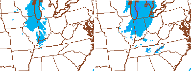
Lows by Friday will range from the high single digits to the low teens. There’s a touch of warm air advection (no it’s not going to be warm) and that can fire up some light snow or flurries. The simulated radar from the NAM shows some of this…
This is ahead of a powerful arctic front sweeping in here on Saturday. This front is looking more and more energetic the closer we get and that increases our snow chances. Check out the GFS…

If that plays out, accumulating snow and blowing snow would be around for Valentine’s Day as temps crash. I’ve seen similar setups produce some thunder.
Temps by Sunday morning may flirt with zero as wind chill numbers go well below zero. Monday morning may see single digits again as we turn our attention to a potential storm system.
The models continue to show this system very, very well. That’s all you can ask from 5 days out as it is way too early to even be talking about “trends”. Wait until a few days out before doing that.
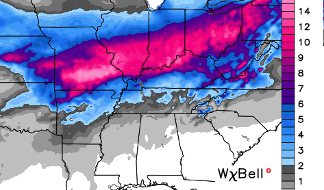
Here’s the GFS snowfall forecast…
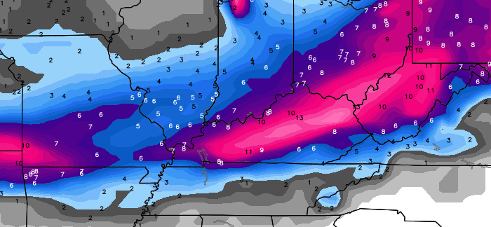
 The Canadian Snowfall forecast…
Let me stress to the absolute max to take those and any maps with a grain of salt from this far out. I’m just showing them to illustrate the point I’ve been making for the past several days. There is likely to be some kind of winter storm from the Midwest to the Ohio Valley. That’s about all I can tell you, right now. It’s too early to figure out what impact, if any, that possible system has on our weather here in Kentucky.
Regardless of the impact… another shot of arctic air follows for the middle and end of next week. If we can get some snow on the ground… record cold would be possible. IF.
I will have another update later today. Take care.

Possible snow day for schools around Ashland, KY tomorrow?
Nope
Bad timing for snow or you don’t think we will get any?
If it happens as forecasted some place won’t have school for several days
Still doing my Spring Weather dance.
I think the GFS is onto something because it keeps the heavier snows well north of the Lake Cumberland Area….seems par for the course even if it is 5 days out.
I agree. North is where all the snow has fallen and the GFS seems to be trending that more and more.
Nice name by the way.
regarding to potential storm next week.
I think we’ve learned our lesson a couple of weeks ago.
wait until the storm arrives on land.
And that is what CB is pretty much saying, so will be curious if the ‘agendites’ still stretch it.
If the cold comes in as forecasted, these next four days, then we may be singing ICE ICE BABY! Not like a storm is rolling across with little cold to work with.
I agree if it did warm enough to rain the surfaces will be frozen.
Thanks CB!
Snow, cold rain, sunny and 70 next week. I don’t care which. Just no ice, please.
Chris –
Wow! This is crazy and sort of has gone along my thinking of everyone saying bring spring because Dec/Jan was relatively quiet…..and I kept thinking about all the times we had no winter, even in NC, until as late as march when all blank broke loose……..
Even still, you can say for everyone to take those maps with a grain of salt all you want, but you know a lot of people will end up just looking at the pictures and thinking that’s what you’re forecasting……..
This
So, given the trend of this winter so far, break out the swimsuits for next week?
Hmmmm….my interpretation for Laurel County…rain, to ICE, to a bit of snow on top….messy messy! North of Lexington…nice and beautiful snow..enjoy!
The weather channel is calling for only rain in next weeks storm for Bowling Green, which will probably be true.
Thanks Chris…You are certainly correct…lets take these things one at a time! Looking forward to the next update. Have a great afternoon, all!
This system will not go too far northward, with the artic cold being around. We just need to watch out for freezing rain.
The Weather Channel is showing 39 with rain in Louisville for Tuesday. They are showing 30 with up to 5 inches of snow for Indianapolis.
Typical…
My goodness, European Model. Looks like the Canadian snowfall forecast… but more widespread across Kentucky.
OOOO Boi…. let’s hope it hovers over us for just a few days until it arrives! 😛
I really believe this will be THE ONE for this winter. Artic air in place before and after. But freezing rain still worries me about this system. A southern system will be bringing warm air, aloft, with it and cold air is hard to move out, at the ground level. Just where will the snow line set up is what we`ll need to watch for. I want an all snow event.
We just need it to come further south 😉
I think it has 8″ right on top of you to be honest. 🙂
Not enough 😀 lol
Bailey cant talk bout trends/// fact is its trending north last few days and in few more days it be a GREAT LAKES storm.. why beaty round the bush, TRUTH HURTS and facts r nothing see here as far as next week storm, be rain then coating snow on backside. I understand gotta keep readers hoolk, but just be CHRIS BAILEY the GREAT WXMAN that u r and give the facts as u know.
those facts r ever model run is shifting North/NW..
Ummmmm no there not the Euro shifted south today. Last night Euro run had the heaviest snow in central Indiana this afternoon Euro runs places the heaviest snow back in Kentucky. The model waffle effect is on till about Saturday.
The colder air should help. Key word “should” and presumes it stays cold and we do not hit a temp spike.
CB went out of his way NOT to hype and to the point of being subdued. Not sure what you are reading.
If you are referring to his posts up above, CB is obviously having fun IMO and not hyping.
Thanks Chris! Great update as usual.
Go Cats!
Did you not read where he said that this is DIFFERENT because there is arctic air BEFORE and AFTER so it will be difficult for it to go too far north………I’m my worried about it going to far south!
Doesn’t matter if artic air is here before and after. We have seen this Winter how easy the cold air is blown away by a southwest wind. I hope this is different but the trend is moving it toward Chicago and Detroit. My gut feeling is this will play out again, NAO is still positive that is not good for snow for us.
Jimbo, the Euro trended south today not north.
The average of the models seems key 🙂 Cherry picking models has not proven to be a very reliable strategy- especially this winter.
As Chris said there is no trend for this storm yet just waffles
That’s good news, I hope it continues.
I think it will make a northeast jog somewhere.
I hope it is past Kentucky before it decides to move north east.
according to my local met Brian goode we really will not have good info until late Friday or early Saturday.
Lake Cumberland needs snow, but even with these great maps, we are in the “tiny” category. sigh
After this storm system arrives, I would love to see a graphic showing each map’s (GFS, Canadian, NAM, etc) snowfall forecast starting 5 days out until the day of the storm.
Yes, that would be interesting.
NAM not in play 5 days out
Watch it trend south and the sweet spot becomes middle Tennessee and into the Smokies of East TN and western North Carolina.
Still, days away folks. And I think the usual suspects will get hit (Indiana, Ohio and up into the northeast)
Once again, the football is being placed on the tee by Lucy, and nearly everyone here is falling for the model madness.
Well Charlie, that could happen.
Western NC is where I’m from originally, and I always remember when snow was forecast, upstate SC (which was in the WLOS Asheville viewing area), would get a separate forecast because they weren’t in the mountains. Upstate SC never got as much as we did in western NC…..I often also remember them saying the northern mountains would get snow, which often left us out.
The weather here is SO much different than it is there it’s crazy.. Especially the overcast we have all the time. We didn’t have that there unless there was an actual storm over head or one moving in.
Thanks Chris for all you do!!! I am hoping for SNOW and not ice. I live on a mountain so to speak. You can travel it in snow but ice makes it impossible for us to go anywhere. The salt trucks have even slid into the ditch on either side of the road. I am a snow lover anyway!! Again, Thanks Chris!!!
SPRING LUVERS VS SNOW LUVERS yep our WXMAN is against us SNOW LUVERS, has turn my woman into a READY fur SPRING think too!!! BAA HUM BUG!!!!!
That’s okay. You will always have your goats to snuggle up to 😉
Little eye candy. I’d like one good thumping before spring. Still ain’t gonna kick that football till bout sunday
The models giveth, and the models taketh away.
Better get ready, there’s a train a coming and it’s called the Polar Express. Get your ticket and get on board.
Just don’t say that national media/met concocted term “vortex”.
A little of me dies each time CB notes it on his blog.
RAINdrops keep falling on my head! Please move along Winter, you failed.
Rodger has seen the latest GFS and it HAMMERS much of KY with heavy snow! Too bad it’s still days away and the models will change with every run. Rodger in Dodger!