Good Tuesday bloggers. I can’t think of a whole lot of words to describe just how perfect the weather on Monday was so I will settle on AWESOME! ![]() Today looks like yet another great weather day so get outside and enjoy it as we do have some weather changes coming that will take us into a wetter and MUCH cooler pattern.
Today looks like yet another great weather day so get outside and enjoy it as we do have some weather changes coming that will take us into a wetter and MUCH cooler pattern.
I know what you are thinking… can it get cooler than it has been during this so called summer? The answer is… yep!
As for today… highs will be in the low to mid 80s after we start the day with temps in the cool upper 50s to low 60s and a touch of valley fog. You can track today’s temps across Kentucky through the good folks at Kentucky Mesonet… 
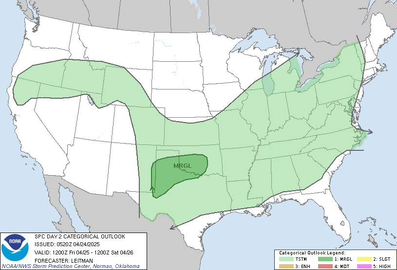
I mentioned a change coming and that will begin Wednesday with showers and thunderstorms increasing during the second half of the day. Some of those storms may be strong or severe and the Storm Prediction Center continues to place much of the area under a risk for severe weather…
How does the rest of the week look? The 5 day has the answers…
I did bump up the temps for Wednesday and Thursday as any sunshine will cause a nice jump in temps. Highs both days should be in the middle 80s with a shot to go higher if the rains hold off until later on each day. Locally heavy rains will be likely during this time and some of those showers and storms will likely hang around into Friday. Highs will come down with upper 70s to around 80 for Friday as that signals the start of another VERY cool period.
The weekend into early next week can get pretty darn cool with several days of 70s for highs an increasing possibility. I cannot rule out this period averaging as cool as the one we had a few weeks ago to start out July. As a matter of fact… the overnight lows will likely be much cooler than we had the last go around.
This has me dusting off the record books again. ![]()
Why so cold? The jet stream continues to be displaced very far to the south for this time of year and Canada has been as cold during the summer months as I can recall. As the jet dips… that chilly Canadian air filters south into the country. You can see that here…
GFS Upper Air Chart Saturday Morning
That is amazing to see in the middle of July!
I still cannot find anything that looks like a summer pattern over the next few weeks. The pattern says summer is overrated and I tend to agree! ![]() I already have some thoughts for the next few months that I will be sharing with you over the next week or so. So far… the summer forecast has been a winner.
I already have some thoughts for the next few months that I will be sharing with you over the next week or so. So far… the summer forecast has been a winner.
Have a great Tuesday and take care.
Select Page
Chris,
Where is your 5-day forescasted targeted? Is that for Lexington, Huntington, or somewhwere in between?
wow. I’m in Nassau Bahamas right now, and the Real Feel heat two days ago was 114, and 104 yesterday. I wish that stuff would filter a little further south so the mission teams can have some decent sleeping weather.
I am LOVING this cooler than normal summer. I moved here from FL to escape the heat. 70’s and 80’s are perfect for me! Keep it coming!
I agree! I love this weather and these temps.
Chris, your doing a great job! Thanks for the hard work. This great weather pattern we have had all summer, there is no great words to describe it.
The temps are great, but the ground has become very dry. 75% of my lawn is now brown, and my plants/trees wilted while we were on vacation. We need a good dose of rain here in Georgetown.
This is the best summer weather. I love it! Thanks for the update Chris.
Well, Chris, we have hit 88 degrees again today, here. It was a cool 57 this morning, but has warmed up considerably now.
I think this whole year has been an odd one weather wise. I have a feeling we might get our heat in August. YOur thoughts on this, please?
Hey did you ever find out why your Sunday post was sent out again yesterday afternoon? I just thought it was kind of odd….
Anyway, have a good rest of the day. Looks like the way you are talking, you might be a busy man tomorrow and Thursday!
Did anybody just see what I saw? The MLB allstar game on FOX started out great. Then they bring in Obama to throw out the first pitch. And FOX just CENSORS it. UNBEVIEIVABLE. I just wanted to see if a sitting president could get to home plate. I know this is not a political forum, but geeeeshh.
This is the first summer I have enjoyed in a decade. I LOVE the cooler temps and low to no humidity! I feel like a kid on vacation and I can play outside all day.
I agree with David, we could use a rain, but I’m not as dry as he speaks of.