Good Thursday, everyone. The long hours are catching up to me so this will be a rather short (for me) post. I promise to make it up to you with the updates later today. That’s once we thaw out from record breaking cold temperatures. Oh wait… you mean we aren’t going to thaw out today?
The headlines…
– Highs today will hang out in the single digits for many areas as wind chills stay below zero.
– Record cold will be with us again Friday morning. That’s when temperatures can really go crazy.
– I’m still trying to get a firm handle on how the weekend system plays out. It continues to look like a snow to wintry mix to rain then back to snow setup from late Friday through the weekend. Let’s wait and see how the models look later today into Friday. I know you want to know more… but that’s all my fried brain has at the moment.
– Another huge cold shot follows all this up into the middle of next week…

– That could deliver another shot of bitter cold temperatures. Below zero, again? Maybe so
– I’m seeing a growing signal for a storm system for late next week into the following weekend. It is showing up on the models to some degree…
I would love for spring to show me a sign that it’s ready to go… but I can’t find anything that remotely resembles spring into early March.
See you later today with better updates. Track today’s cold until we meet again…


Have a great day and take care.

really hoping to avoid ice here in SE KY
Really hoping to avoid -15 to -20 temps also.
Probably not
get some rest chris. let micah harris and jim caldwell help while you rest a little. this week has been rough for all your team.
i do not look forward to the cold temps tomorrow night and the weekend storm. not good situation any way you put it. also not looking forward to next weeks cold temps.
im bout ready to get in spring mode. im a winter person till the last possible second i can be winter, but im bout ready to get in spring mode.
So basically, CB or no other met has any idea on what’s going to happen this weekend.
nope.
On the positive side, if they thought it would be mainly ice they would be word clouding that word a lot more by now 🙂
Guessing 50% snow, 30% rain and 20% sleet/ice. That mix would be more rain the further south. The more plain rain the merrier 🙂
That’s a nasty mix on top of what we got, so hoping my plain rain ratio is too low.
I like the way you thinking Bubba. I totally agree.
Mets are thinking a lot of 34 degree rain and less frozen stuff. We seem to be on the cusp of pure awful, so hopefully the temps are above freezing as being forecast 🙂
Mets are now saying mainly real cold rain and less frozen stuff, but CB has not weighed in yet.
My husband just got home. Got two hrs sleep last night and it will be the same tonight. I understand long hours. Try to rest when you can. We all want updates, but updates are not as important as taking the time to rest when you need it. Take care of yourself.
I don’t think I could function at all on 2 hrs sleep. I don’t see how some of you people do it. I couldn’t.
This
Firefighters and us EMS workers are used to it.
God Bless you and all of our emergency responders! Your dedication is what keeps us safe especially in these frigid conditions.
I am honestly very fortunate to be off today and tomorrow, so I am missing the worst of the “cold calls”. It could be much worse.
3:30 am THURSDAY,1*@ blairs mills , morgan ,co, wet/cold weekend coming,keep up the good work CB!
Airport in Henderson reporting -11° F and -23° windchill @ 2:55 A.M. How low can it go?
Cold cold in north Morgan co -1*
-1.3 here in my part of Knott County.
Experiment success with car start this morning.
1) pack snow around the driveway a little higher than car hood to block air flow
2) cover engine with spun polyester blanket under the hood.
don’t use cotton, terrible cold insulation. I used a $4.88 one from wally world. Too cheap for wool. Barely cold to the touch when removed, it was put on after engine was cold actually. Surprising.
3) start like a champ despite coldest ever temp for this 13 yr old car @ -13.
Our ’98 Escort with none of that started right up. -7° Please let this weekend be the lesser of all evils! Too old for more ice!
-9 so far may squeeze out another degree before its over
-1 here in east tn with MINOR snow pack..this is cold air…lows gonna be in 30s all the way to Miami fL.
WINTER STORM WATCH….here in tn…3-6″ of snow exp. Here then sleet and freezing rain….
good luck with that,
Weekend Temps As Of Yesterday,Sat45/38,Sunday45/18
Temps Now For Weekend,Sat41/33,Sunday35/11
they keep lowering the temps for the weekend, all are saying 5-8 of heavy wet snow
Location?
Athens Ohio Near Ohio River
I have -23 on two different thermometers here on the banks of Boones Creek in Clark Co.
Thank you Chris for everthing you do.
-2 in Carrie of knott co this morning
THANK YOU for all you do to give us continuous, thorough updates. I am so glad I discovered your FB page all the way up here in Burlington, KY! Get some well-deserved rest! You’ve been busy!
Get your rest CB. Going to need it to get through the weekend mess. And what a mess it may be. Hopefully the cold wins out and we have all snow. Just don’t see how surface temps moderate up above 32 degrees. Freezing rain seems more likely than plain rain.
Thank you for all you do. Get some well-deserved rest and enjoy your day!
In the past most warm ups have temps higher than expected. With this cold, not sure how the southern surge will come into play. Any mets making a call on snow vs rain? Amounts?
Should we make another grocery run to prepare for the weekend??
I know you must be totally worn out, but you have done an outstanding job. Get some much needed rest and thanks for all you do!!!
Knoxville at 7 degrees with windchill of -6. Almost all major roads are clear; however, some subdivision and more rural roads still have some ice. Dealing with ongoing power outages due to ice buildup on trees but not as many as earlier in the week. Hoping for a weekend thaw but doesn’t look too promising.
If the air temps do get to 40 on Sat. what about objects near or on the ground? Because of snow pack wouldn’t any rain that fell just freeze on impact? Even if temps stay in upper 30s or 40s I can’t see much snow melting even in 12-24 hours. I hope I am wrong. Help.
I agree. That’s another debate if temps due get to 35-40 degrees considering the snowpack and how cold it is at the ground more than likely even with pure rain it will freeze up one world think. Maybe not to trees and powerlines. Its a unfamiliar setup that we just haven’t experience record cold huge snowpack. Start off as snow transition to sleet then freezing rain then rain on top of a huge snowpack. Im still not thinking the models are grasping the amount of cold and snowpack already in place. The mets are just not confident on how all this unfolds. If temps dont get above 32 there will be problems.
And if temps due get above freezing how long will it take for that to happen and how much above freezing do the temps go? In my opinion even if temps get to 35 degrees im not sure that 35 degrees makes a huge difference considering how cold the ground is with a huge snowpack. I guess you can make a case to have a temp of 35 degrees and still have freezing rain at ground level but trees and powerlines would be ok as weird as that might sound.
We are just a few degrees trend from a messy to a nasty bad weekend. Not seeing how south of us is calling heavy snow and we are mainly cold rain with marginal temps up to 10 degree lower.
Not adding up, but hope local mets are correct with current forecasts and CB does not lower the boom with an update.
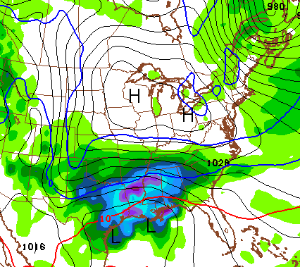
12z NAM coming in stays colder for longer major winter weather threat for central and eastern ky. I’d be willing to bet if trends continue CB will update to winter storm alert today.
Saw that and agree! 🙂
Rodger just saw the new NAM model and it’s further south, weaker and MORE snow/ice for much of Kentucky! As usual, Mr Bailey seeing these trends well before the models do. Strap in for the ride! Rodger in Dodger!
12z NAM looks to be trending colder for Saturday. Anybody else see this?
Yes. I think it’s finally picking up on the snow pack and cold air. Looks like the 12z wants to give central Ky. a heavy wet snow for a while and then at that, not wanting to warm up much above freezing. Midnight run of it will interesting tonight.
Does it look like the storm next weekend is going to be snow or another “wintry” mess?
We had a snow to rain event in Lex in 94 after the big snow. Had four or five inches of snow, then the rain came down onto the snow pack. Formed a crust of ice on top of the snow. It looked absolutely horrific, but was no big deal. You would just punch through the crust as you walked, and it actually made the roads better.
Yep, but there was more of a time gap for the event was warmer prior to it and above freezing continued. This event is going right against the super cold temps and another cold period starting on Monday.
Wish it were the same set up, but this has potential to be a problem due to the timing. Let’s root for a warm trend 🙂
its trending colder
12z NAM finally picking up on the snow pack and cold air. Looks very interesting. Maybe a heavy wet snow for central Ky?
If Chris goes by the 12z NAM, I would say he goes into threat mode today. Also, wouldn’t be surprise to see the WSW in Tenn. be moved up into Ky.
What does it look like for the louisville area?
Less precip. than the Lex. area, but still some snow. Model runs will change as we get closer. Midnight runs will tell a better story. I expect them to trend even colder. We’ll see.
I’m interested in WHY it is going to be so cold here, when the forecast for points north of us (Cleveland and Chicago) are only showing 0 or negative single digits. It just seems weird. Sorry, but I can’t find any explanations online.
Because the arctic air, aka polar vortex is center over Kentucky, not Cleveland.
Wake up Chris, this is getting interesting
Heavy wet snow not good…definitely a grocery trip before the weekend.
Your local grocer approves this message 🙂
Don’t have access to the models, how’s the NAM look for Rockcstle and Laurel counties?
Hoes it look for ne ky? I’m in louisiana enjoying the weather 🙂
Take every scenario and get ready. If nothing major happens this weekend no biggie…you’re ready for anything.
Which model is up next for us to look for trends? GFS?
Yep
12z NAM says uh-oh shows significant snow for north central ky trended much colder more snow more freezing rain. Just one run lets see if it continues
As CB says, we need to look at all the data as we get closer to the event. Most local mets should take this stance as well.
Looking for consistencies from each run.
You are right!
Our roads are still awful up on the ridge in greenup…my pops said we got almost 4 new inches of snow yesterday which would put us Over a foot…if we get heavy wet snow, the electric will go out
12z GFS in board with 12z NAM… looks ugly.
Is there a link to this? I would like to see the models. Thanks.
Gfs holds the cold for a while before dislodging the cold when the low moves over ky.snow, to a mix, then all rain, back to some snow on the back end. In other words a mess.
CB just tweeted and said the GFS has trended colder with the NAM.
What does the 12z runs of the NAM and GFS show for Highs in the Lexington area? Also, what is it showing precip wise?
12z gfs says wait NAM i think your on to something lol
Does this include the Louisville area, sorry if someone already answered this.
YES!
Yes it does
What do the new model runs look like for southern Kentucky, specifically Bowling Green? More snow or in a dangerous ice position?
I tried to tell you guys….
sigh….lol.
my initials are the same as Chris Bailey’s. This should qualify me as an insider. 😉
Sooooo NWS in Louisville do you need help picking your jaw up from the ground after looking at the new 12z runs?
Like!
haha….and yes, I believe that was mentioned yesterday, too.
They wen’t from 1-2″ of rain…to, starting out as some light snow, a brief mix, to all rain.
and now? hmmm….when will they stop believing the models 5 days out?
I don’t want to start a big debate, but the NWS guys work very hard and they deserve our respect.
We should be happy to have several different opinions on weather and always show respect to everyone’s opinion. We can agree or disagree, but show respect.
Think Snow!!!
I agree 110%.
I’m not saying anything that our very own weatherdude on this blog hasn’t said.
I think the NWS is GREAT during the spring and summer storm months. They know plenty more than I do.
Winter seems there are so many more factors involved in forecasting and they just don’t seem to break all those factors down. Instead, they tend to go with the warmer solution most times, because over the years, the trend has been that. You just have to learn how to adapt to the trend changing.
Vinny, nothing against the NWS in Louisville there actually one of the better government run outlets, hands down. However they jump the gun on this one. Im not saying the NWS is not right very well could be. There were and are to many factors that were unknown before coming out with a somewhat confident forecast 2 days ago.
I completely understand, but they have to put out a 7-day forecast, and they will always be conservative until there is majority model agreement.
We all like the snow maps, 540 line and so on, but there is Sooooo much more data, soundings, trends, anomalies, and on and on and on…
Very smart people look at it all, and give us THEIR opinions. Some hit, some miss, and so goes winter in KY
correct 🙂
Did you stay at a holiday inn last night?
I love reading your take on things and your close to me. You’re getting what I am.
Thanks for your input.
nope…the comfort of our home.
not a problem. It’s fun. I would never have learned as much about weather and how to read the computer models, without following Mr. Bailey over the past few years.
I agree with that 100%. In high school at Manual (back in the 80’s) I took a meterology course at UofL. John Belski was one of the teachers. I have followed him ever since. I used to call him Lord Belski. Over the past ten years KWC/Chris Bailey is my first stop every morning. CB is the king of winter weather although I still visit Belskis blog.
Can someone please post links to the 12z GFS and NAM? Thanks in advance.
Supposed to drive to Missouri on Sunday…not looking forward to trying to get out of KY. Any ideas if this system will still be impacting us?
Here is the new NAM
http://wxcaster4.com/nam/CONUS1_NAM212_SFC_ACCUM-SNOWFALL-KUCHERA_84HR.gif
CKY gets another hit? Wow, thanks CB
Could this have the “POTENTIAL” of being like the last system?
For those interested look at the “trend”
00z NAM-http://wxcaster4.com/nam/CONUS1_NAM212_SFC_ACCUM-SNOWFALL-KUCHERA_84HR.gif
06z NAM-http://wxcaster4.com/nam/CONUS1_MESO-NAM212_SFC_ACCUM-SNOWFALL-KUCHERA_84HR.gif
12z NAM-http://wxcaster4.com/nam/CONUS1_NAM212_SFC_ACCUM-SNOWFALL-KUCHERA_84HR.gif
I live in a flood prone area. As bad as I hate to say it, I hope we get anything besides rain. Just really can’t see that much of a warm up though, so maybe just a little rain wouldn’t be so bad. Hopefully, not enough for flooding.
agreed Knox is a flood prone area as well
but I would rather not have ice
Not very much moisture in the snow on the ground. I was a 15-1 ratio so most places received under a inch of precip. Flooding should not be and issue for most.
don’t tell that to WLKY lol
How does it look for southern Kentucky? Bowling Green area.
The 12z GFS has a lot more moisture than the NAM. Its a complete hodge podge of everything precip wise. Im not sure if the 12z GFS is over dueing all precip amounts or maybe it’s just now starting to figure all this out. 12z GFS looks to be coming out of anesthesia still groggy give it time but it’s coming.around.
the NWS got a very important detail correct.
there is alot of moisture involved with this system!
NWS has scheduled yet another conference call for 2:30. Boy, this is getting serious
Dag gum right its serious. Im fully expecting a heart felt apology from the NWS, stating that they did jump the gun and a conference call will work. Just kidding.
wouldn’t be surprised to see Winter Storm Watches being posted this afternoon or evening.
Ok, This started Sun night…..It’s not Thursday! I feel like this week has been a month long! LOL
Actually, it is Thursday…
Ok, why are my smily faces not showing up!!! 🙂
They are❄️❄️❄️❄️
I know it was a typo – not was supposed to read “now”
I kid you not….even after the new data, WLKY Noon weather just said a little snow Friday night, transitioning to all rain all day Saturday and Saturday night, with 1-3″ of rain and flooding potential.
WOW!!
How will they explain that forecast if the NWS issues WSW later today? goodness.
He mentioned nothing in the way of any snow or ice accumulation.
I stand corrected…it was WHAS-11.
Sorry about that WLKY. ugh….WHAS is the one who always uses old data and the warmest solution in every single forecast.
Where is CB?
He’s waiting for EURO to be released probably and getting ready for a Winter Storm Threat mode?
Kristin, I noticed your comment above about why it’s so much colder her this morning than areas to the north….
It’s snowpack and cold high pressure moving over our area……It’s weird but I’ve seen the US temp map and a lot of times it’s colder here than places like Rochester, NY, Pittsburg, when we have these bitter cold outbreaks. I think it’s the way the high pressure moves down or something. The national map always looks so similar during these outbreaks. It makes a beeline from the upper midwest southeast to our area from the northwest flow. Perhaps someone else could explain why it’s colder here now than most of New York state. Here’s the national temp map.
http://www.usairnet.com/weather/maps/current/current-temperature/
My opinion is that temps won’t rise as high as predicted. It snowed 16 inches since Monday and temps here struggle to rise. I think this will be an all snow event with another statewide 12+ inches.
New post!
I believe there is a WSW for southeastern KY according to NWS Jackson. Snow and freezing rain. UGLY!