Good evening, everyone. Record setting snows are giving way to record setting cold temperatures through Friday. I have no changes on how all this plays out and have been pretty straightforward on how dangerous all this is.
I’m still trying to figure out exactly how our weekend of weather plays out. Some thoughts:
– Snow develops across western Kentucky on Friday and lifts to the northeast across the rest of the state during the evening.
– Accumulating snows may be noted before we get sleet and freezing rain to begin to take over late Friday night and early Saturday. The first half of Saturday looks icy as temps struggle to get to the freezing mark.
– Rain may TRY to take over for a while later Saturday into Saturday night, but I suspect the models are still too warm with their forecasts. They are also likely too strong and too far north and west with the surface low during this time.
– We are already seeing some subtle changes in the GFS. That model brings snow and ice to rain, but is now showing a much flatter solution that allows for the cold to quickly return on Sunday…
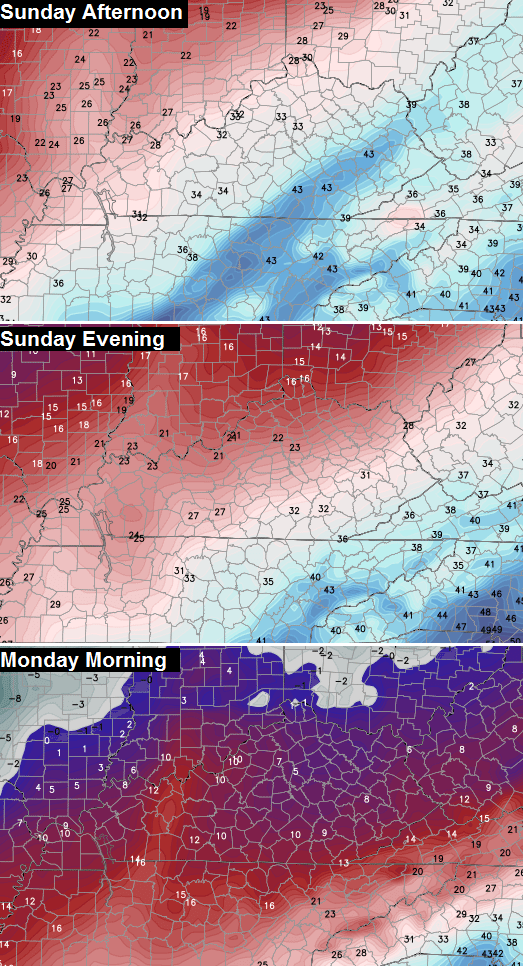
Is that the first signal that the model is seeing the expansive cold air and snow pack in place? I guess we will soon find out.
This same model run changes whatever is out there on Sunday to snow and puts down accumulations into Sunday evening…
There is a lot of “nasty” potentially lurking this weekend. Trust no model or “all rain” forecast, right now. I’m not saying I know exactly how it’s going to play out, but I’m also not one of the folks telling you there’s nothing to see here. 😉
A full update comes tonight. Take care.

What are the chances it might stay all snow with the weekend forecast? I mean I don’t like the white stuff either, but it sure beats ice/ freezing rain. 🙂
Thanks as always, Mr. B.
It is going to be very interesting to see the model trends tonight and tomorrow. The NWS is going to freak out if the artic air is in fact stronger and the low weaker to allow for a longer period of icing to take place on Sat. Their last discussion has us changing to plain rain by late Sat morning and continuing through Saturday night.
Thanks for keeping us aware of the potential that this system has CB!
I wished for this snow, for the last several years. Finally got the snow day I was hoping for on Monday (yes, my co-workers blame ME), but have since been dealing with the commute – a “downtown” Lexington one I might add – that has had its challenges, mainly the side street I call home. I’m here more than ANY social media site and anxiously wait for you updates! Enjoy reading the comments from those that follow and understand the details much more than I do. Thank you Chris! (and all you contributors!)
Thanks Chris. Will be checking back often as this weekend is a little scary.
Don’t envy forecasters this weekend.
Nice coverage from CB on the weekend so far! Very measured. Will be funny if it does trend colder cause he is sniffing it out and will be awesome he makes the call before one else.
I would rather have snow than ice any day but I guess we just have to take what we get and go on with it. The snow I have been crying for for the past 15 plus years I finally got and I am happy with it so the rest of the winter is just whatever I guess. 🙂 everyone stay safe out there the next few days and thanks CB ….
If it does trend colder, I wonder how much ice we would end up with. Anything over 0.25,” and trouble starts.
If it trends colder, we better really hope it is in the form of sleet and/or snow.
Ice would be devastating for anyone who didn’t transition.
1-2″ of moisture involved here.
I’m with you Kay, and I don’t live in Kentucky. I live in Virginia. We had 6.5″ of snow on Monday/Tuesday! Love Chris forecasts because usually what happens in Kentucky comes to Virginia. Although most of the time it never make it to central Virginia. I’m glad it did this time. Our local meteorologist is calling for sleet changing to rain on Sat. Very cold, record breaking temperatures for Thur, and Friday. Wow! I guess the persimmon seeds didn’t lie afterall. 🙂
Plain rain FTW!
Hope Mr. Torch wins this one. Really.
I only like the light “movie” snow we got. Heavy wet snow to me is the same as ice. Nasty stuff.
sadly, I don’t think blowtorch wins out, Bubba.
Hey Chris, can you update after each and every model run, or at least once per hr?
Thanks buddy, you’re awesome
Oh come on dude! Surely you are kidding/sarcasm?
Also, since you know where I live, could you stop by and shovel my drive? I blame YOU for this mess!
HAHA
Like
Winter Storm Watch for east TN for heavy ice and snow Friday through Monday. Somebody is sniffing out the power of arctic air and snowpack.
I expect met flares to be firing off some point tomorrow. One to two inches of whatever the result is on top of the current stuff seems bad whatever falls.
Rain or anything slightly liquid will percolate to the bottom and then create and ice layer…more fluff on top and it takes a considerable amount of warmer something to melt….and the freeze/thaw with added winter precip extends the process and mess. Sigh. But would not change one thing-it’s winter.
It is a shame that I have to come here to get a good accurate weather report. I don’t even live in the viewing area but close enough to see what is going to happen. Thank you Chris B!!!!!!!!!!!!!!!
We are very fortunate to have you have take the time out of your day and keep us posted using this media.
Now please bring spring
My gutters are pretty unhappy right now. Can’t imagine what ice/freezing rain would do to them on top of all that snow! I will be watching for your updates as always! Thanks for your hard work and dedication to keeping us prepared!
Thank you Chris for excellent job you do in keeping us informed of the weather. You truly are the greatest!!!!!
I seen it go from 10to 50 in a day last year with snow on the ground
so, -10 = 30?
and quite a bigger snowpack to boot. 😉
I have too…….But not this much snow and this much WIDESPREAD snow, all the way down to the border and these kinds of temps… Tisk Tisk….In a pattern like this, you don’t know what will happen until you’re probably now casting…….
Look at the model madness this winter until almost the day of the storm and the changes. It’s Wednesday night. Do we really want to trust what the models say for Fri-Sat-Sun, yet? I dunno.
I known Chris was spot on with this last storm but I’m thinkin the next ain’t gonna be nuthin but our usual cold rain. I’m just glad we got in a good one before old man winter leaves us. Bring on the spring weather and the shorty shorts. I’m over the baggy sweats ladies.
wrong….sorry. 🙂
Now I hope you mean wrong on the rain and not the shorty shorts. Unless you like the walmarts look of the sweat pants my lady has had on for going on 4 days now.
haha….this could go many ways.
I second the shorty shorts
I’ll take as much snow as Mother Nature will throw at us. I miss my upstate New York winters. Although I could do without all the senseless people driving in it. Thanks Chris! You are the best.
This might be one where the actual mix type is not known until within 24 hours.
Just saw models showing crazy amounts of precip in Ky. this weekend…but I cant tell if it was rain or snow or the I word ……
Not much snow. Mostly a mix and plain rain.
mainly rain after couple inches snow Friday nite. upper 40s Saturday.
In Georgia and parts of Tennessee maybe, but not seeing that high in much of Kentucky. Would be nice though to wash stuff away, unless in lower flood prone areas.
Hopefully CB has a more clear idea with his update.
Your forecast changes as much as one changes their clothes!
Please, I went through rain (trying to run through frozen gutters) on top of inches of snow and it was a nightmare. Snow on top of snow would be better. Well, I know I’ll be checking this blog often because I want to know as soon as possible what to expect. Thanks Chris for your expert forecasts and updates.
what does CB’s tweet about “flatter” looking system mean?? TIA
Means not as strong of system…low going south of ky and a colder solution
In terms, less rain 😉
If it goes south, does it take all the precip with it and we just end up with cold (which is better than ice) 😀 ?? Or are we getting some precip and that means snow/ice??
I wonder how much colder? And if it means the majority of the event could turn out with frozen precip? If so, hope it’s not a ton of freezing rain. We can handle snow and sleet. FreeIng rain is no joke.
Perhaps a lack of quality sleep has me paranoid, but his wording seems ominous in the tweet. I have seen that wording in relation to ice events a few times.
I am siding with lack of quality sleep 😉
Also can mean less variability in the mix type of precipitation.
That’s what I was thinking also!!
Very true bubba…you got a map of that? 🙂 I kid I kid
🙂
thanks for explaining flatter
CB great job, enjoy the updates and this is the only site i trust!
00z NAM is spitting out 2 to 3 inches of precipitation statewide. It’s saying about 0.25 of that would be frozen, and the rest would be plain rain with temps holding in the mid 30s north to mid 40s south. NAM has been trending warmer with each run. Remember, this is only one run from one model.
We might end up with the chocolate and peanut butter coming together and creating one NASTY Reese’s Cup. Seems no way this amount of cold air will surrender in a quick fashion.
I suggest we all buy war bonds supporting the warm side 🙂
I know, seems impossible. But it will be a tough battle though. Hopefully it will be mainly snow with no ice or a good ol’ Kentucky plain rain.
this rain talk is going to really backfire…I wish it would stop.
We are going to end up with a sheet of ice everywhere, otherwise!
No way we end up with mostly rain.
That’s what I’m thinking, but I don’t really hope for a colder solution unless we can get mainly snow, which seems like a far stretch without any ice involved. So, plain rain is the best way to go!
oh, I agree with you. This is going to be no fun at all.
What is a “flatter solution” ??
CB makes that vague statement without explaining much, other than “Why? Snow pack and arctic cold.” You would a-ssume he’s talking about a colder solution since he does mention how cold it’ll get plus the deep snow pack we have. But as Bubba mentioned, it could mean a less variability in the mix type of precipitation, just as the 00z NAM is showing. (Mainly rain)
Been in Kentucky for many, many years, and the one thing you never do, is under estimate the power of WAA. It will shock you once it gets rolling. We might see a brief period of Frozen crap, but a cold rain will win out (JMO)
When I say “we”, it’s strickly for Lex-metro
True true –
However, we’re so used to that because of the last 17 year pattern we’ve been in. I mean, when is the last time almost the entire state has seen this deep of a snowpack? It wasn’t 1998 for the entire state, so maybe 1978, Chris just said on his forecast……So yea, never underestimate the power of WAA, but also don’t underestimate the power of this crazy historical pattern either.
Exactly what i said several posts ago. Just like Cb says “Never underestimate the North West flow,” you should also never underestimate the power of WAA, especially in KY.
Ironically, it’s kinda the same thing; sometimes it works in your favor, sometimes it doesn’t
Flatter means the low goes more west to east than from south to north. If the low goes more east and less north then it means a colder solution for kentucky.
By re-reading CB’s tweet and thinking about it, “flatter” does mean more west to east. So to find out whether it’s colder or warmer solution you have to look at the origin of the low pressure. It is going to come from the Rockies, which is at a more northern latitude than KY. So I would guess that it’s a more warmer and northern solution. But what prevents me from thinking that is the arctic cold and snow pack that was mentioned. So basically, I have no clue. (I comment too much sometimes lol)
Nah, that’s what the blog is for, dicusion.
What exactly does “flatter” mean?
less boob
Besides that.
And I guess I should have read through the comments before I asked. Blonde moment.
Yeah, everyone has no clue.
I felt so dumb asking that question. I’m glad to know no one else has much of a clue either.
I almost asked on Twitter twice then chickened out & thought I’d ask here.
Anyone notice that monstrosity of a storm showing on the GFS next weekend. I know it’s far out but that bad boy with a slight NW trend would put us measuring snow with a yardstick. Tons of gulf moisture with cold high pressure to our north.
I’m glad you brought that up.
Next weekends storm has a chance to be the biggest one of the winter! 😉
Where do you look at future models at? Stupid question I’m sure.
Model data is mainly a paid for subscription with a provider. (Just like how there are different phones from different providers like Verizon or AT&T) Some providers for models are free but contain little data or sucky graphics. WeatherBell is the most popular paid for subscription. It is awesome and has by far the best graphics out there, and it’s used by most mets. The first picture in this post comes from WeatherBell and the second comes from a free website called wxcaster.com
Thanks!
Please bring rain. And not freezing rain or snow.
may they rain fall mainly on your plane 🙂
Biting at the bit till the next update! My husband is out in this mess trying to restore power to the people. Hopefully, we just get snow and no ice!! I don’t see how he, or anyone else, stands to work out in this!
I am going to go w/ what I thought a few months ago-a mid-Feb, Ice Storm along the mid-section of KY…-I live in Nelson Co-nope, not your usual forecast area, but I used to watch (and blog…now I am again!) Chris, and he was always pretty well spot-on w/ his forecasts w/o hyping anything, be it Winter/Spring/Summer/Fall. Always impressed me! 🙂 Even before the Winter Storm Watch came out, I was all over this…still think we’ll see more snow/ice than rain. Temps too cold, more arctic surging in, snow on the ground….but that’s just me…