Good afternoon, gang. I hope you’ve enjoyed the “mild” 30s out there today… another arctic front slams in here this evening and delivers bitterly cold temperatures. As a matter of fact, record cold is likely on several occasions this week as wind chills plummet to dangerously cold levels.
Some snow showers and flurries may kick in this evening as the front arrives. By morning, single digits will be showing up for many with a few below zero. Wind chills will be even colder.
Tuesday morning lows may shatter records across our region…

Those wind chill numbers are brutal!!
Another arctic front arrives with a light snow chance on Wednesday. Temps again head toward the single digits by Thursday morning on gusty winds from the northwest. That will again knock wind chills below zero.
Friday morning temps are brutal… again…
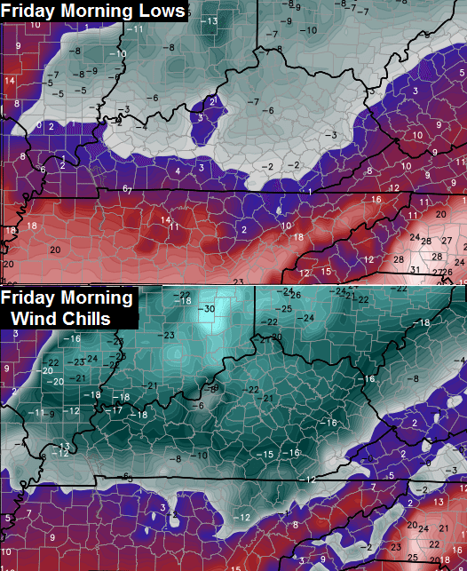
These numbers may be the coldest air so late in the season to ever hit Kentucky. Think about that one for a second! Those same numbers will continue to skew our monthly departures deeper into record numbers. February 2015 may go down as the coldest on record for many cities and possibly the state.
Legendary!
Track the rest of your Sunday in weather…


Enjoy the rest of your day and take care.

Any accumulating snow this week??
No thank you.
surprised CB didn’t atleast throw out the midweek possibility….or as something to watch …maybe its not anything to watch after all 😉
If it were, he have mentioned it.
As Rolocoaster would say, nothing to see here folks, move along…
Think spring!
I would say after this most recent event he needs a break before mentioning more snow storms. 🙂
Your just a sore sport because we actually got one. Keep your football!
If it is going to be that cold there will be no snowstorms, precipitation only shows up with the blow torch southwest wind.
So the 12 to 16 inches we got at 11/12 degrees was all just a dream?
Who got?
I had 14 in Lancaster
Less than half that here warm air caused sleet which cut into our totals and I think that’s the point that Jimbo wanted to make. Not everybody got a foot of snow and not everybody got less than a foot of snow
I never got close to a foot where I live. I also didn’t see any flakes out of yesterdays slopfest. Although I was under a warning for 4-8 inches of snow which turned out to be over an inch of rain.
Mid-week system would probably be talked about if we just hadn’t went through what we did. Probably won’t spend a lot of time talking up a small snow. I’m ready for some warmer weather, I’ve had my snow fix for the year and would like for spring to arrive when it’s supposed to. Doesn’t look like that will happen though.
Are the models still pointing towards a warm-up starting next week or has that been blown out of the water?
Is that storm west of us worth watching? It has a lot of precip with it.
I’m not sure…nobody has said a word about any snow for any of Kentucky.
Yet, the leading edge of this band is almost to Paducah.
I know there weren’t any advisories posted for southern Missouri, but they are getting snow now.
Actually, CB mentions it in his post.
“Some showers and flurries may kick in this evening as the front arrives”
Thank spring!
Yes, as the Arctic front arrives…I did see that.
I was answering about the snow coming from the southern system
The leading edge of that moisture will probably break up as it heads into Kentucky.
Maybe. Kentucky used to get a few decent snows each winter, with ’94 being a history maker, but in recent years the 8″ or more storms have become more rare. I would rather have a couple of 8+” storms each winter than a bunch of dusting and <2". Especially upsetting are the dry cold spells broken up by the warm rainy days.
My feelings exactly. I hate those nuisance snows and dry cold waves. But that is pretty much all we can expect around here. Last week was a rarity.
Well, before 98, this was more common (what we had this winter) at least more common relatively speaking (going 17 years without a huge snow like we just almost all got). It seems it at least happened every 3 years or so. Thanks to these last 17 years, I think Lexington’s average dropped when they started going from 1980 forward for averages, not counting pre-1980, Lexington’s average annual snow was about 18 inches. That changed to 13 inches post 1980, yet the last 3 years have been well above that. So it makes you wonder if we are going back into the cycle 1998 and before? Maybe – maybe not.
Cycles are real 🙂
not much reaching the ground on northern ide this precip sheild
Shoveled more snow in the last week than the rest of my life combined. True story.
A friend just posted on FB there is a storm coming this upcoming weekend. Wonder what that is all about?
I know there is nothing I can do but complain, but I’m ready for this to be over. in ready for pop ups and infield flys.
Popups and infield fly balls? Quintessential Reds baseball. Go Dodgers! 😛
Lol…Little League…but yeah your right.
Jist wanted drop by and let everyone know that I found my kitty today. Shes ok.. was hungry but ok. god protected her during last weeks storm and dangerous cold weather.
Happy to hear you found her!!! 🙂
That is great news! Glad she is safe and sound.
Wait? I must have missed the post! You lost your cat during this horrible weather? I would have FREAKED out worrying sick. Glad you got your cat back……I think their instincts help them out a lot…..
Tell kitty she has to stay inside for the rest of this winter. Glad she’s home safe.
Good news! 🙂
Yay!! Glad she’s safe.
So glad you found her! Our cat disappeared for three days this summer and I was worried sick. So glad she’s safe and sound! 🙂
Thank you everyone. She was as happy to see me as I was to see her. Glad God was watching over her.
The radar looks like we have more cap moving toward ky.
how come no one is commenting on whats in Nashville and Memphis? It looks like precip is headed this way??
Is Louisville radioactive? j/k 😉 By the looks of it, it is a random anomaly based on those maps.
My local station mentioned the late week storm. That’s never happens.